Did you know that you could be reimbursed by FEMA for some of the costs incurred as a result of a natural disaster? The agency has a program in place that can help those affected by storms, fires, and other events. In order to be eligible for reimbursement, however, you will need to complete and submit FEMA Form 81 87A. This article will provide an overview of the form and instructions on how to complete it.
| Question | Answer |
|---|---|
| Form Name | Fema Form 81 87A |
| Form Length | 2 pages |
| Fillable? | No |
| Fillable fields | 0 |
| Avg. time to fill out | 30 sec |
| Other names | elevation form, fema fillable elevation certificate 2020, fema form 90 127, fema forms no No Download Needed needed |
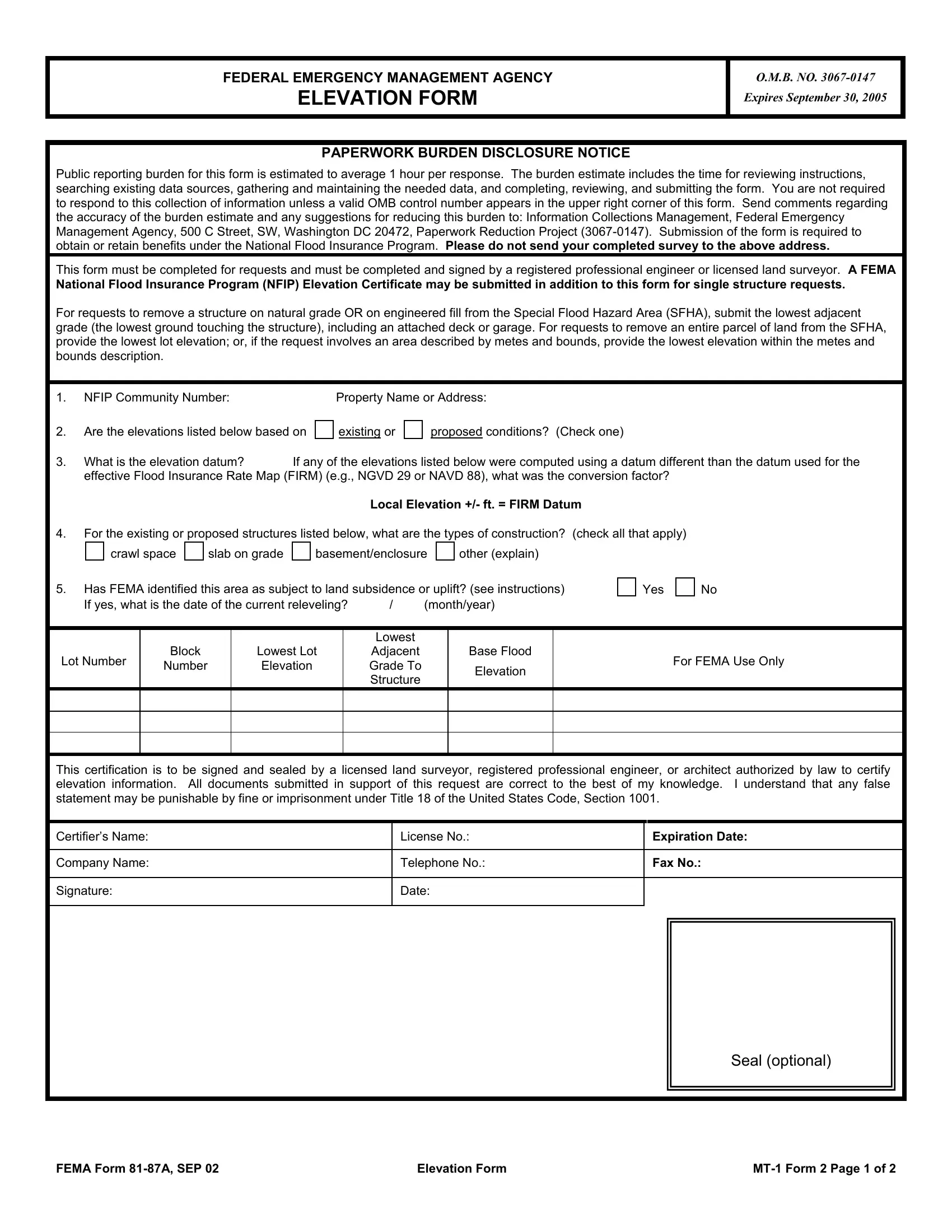
FEDERAL EMERGENCY MANAGEMENT AGENCY
ELEVATION FORM
O.M.B. NO.
Expires September 30, 2005
PAPERWORK BURDEN DISCLOSURE NOTICE
Public reporting burden for this form is estimated to average 1 hour per response. The burden estimate includes the time for reviewing instructions, searching existing data sources, gathering and maintaining the needed data, and completing, reviewing, and submitting the form. You are not required to respond to this collection of information unless a valid OMB control number appears in the upper right corner of this form. Send comments regarding the accuracy of the burden estimate and any suggestions for reducing this burden to: Information Collections Management, Federal Emergency Management Agency, 500 C Street, SW, Washington DC 20472, Paperwork Reduction Project
This form must be completed for requests and must be completed and signed by a registered professional engineer or licensed land surveyor. A FEMA
National Flood Insurance Program (NFIP) Elevation Certificate may be submitted in addition to this form for single structure requests.
For requests to remove a structure on natural grade OR on engineered fill from the Special Flood Hazard Area (SFHA), submit the lowest adjacent grade (the lowest ground touching the structure), including an attached deck or garage. For requests to remove an entire parcel of land from the SFHA, provide the lowest lot elevation; or, if the request involves an area described by metes and bounds, provide the lowest elevation within the metes and bounds description.
1.NFIP Community Number:
2.Are the elevations listed below based on
Property Name or Address:
existing or |
|
proposed conditions? (Check one) |
3. What is the elevation datum? If any of the elevations listed below were computed using a datum different than the datum used for the effective Flood Insurance Rate Map (FIRM) (e.g., NGVD 29 or NAVD 88), what was the conversion factor?
Local Elevation +/- ft. = FIRM Datum
4.For the existing or proposed structures listed below, what are the types of construction? (check all that apply)
crawl space
slab on grade
basement/enclosure
other (explain)
5.Has FEMA identified this area as subject to land subsidence or uplift? (see instructions)
If yes, what is the date of the current releveling? |
/ |
(month/year) |
Yes
No
Lot Number
Block
Number
Lowest Lot
Elevation
Lowest
Adjacent
Grade To
Structure
Base Flood
Elevation
For FEMA Use Only
This certification is to be signed and sealed by a licensed land surveyor, registered professional engineer, or architect authorized by law to certify elevation information. All documents submitted in support of this request are correct to the best of my knowledge. I understand that any false statement may be punishable by fine or imprisonment under Title 18 of the United States Code, Section 1001.
Certifier’s Name:
Company Name:
License No.: |
Expiration Date: |
Telephone No.: |
Fax No.: |
Signature:
Date:
Seal (optional)
FEMA Form |
Elevation Form |
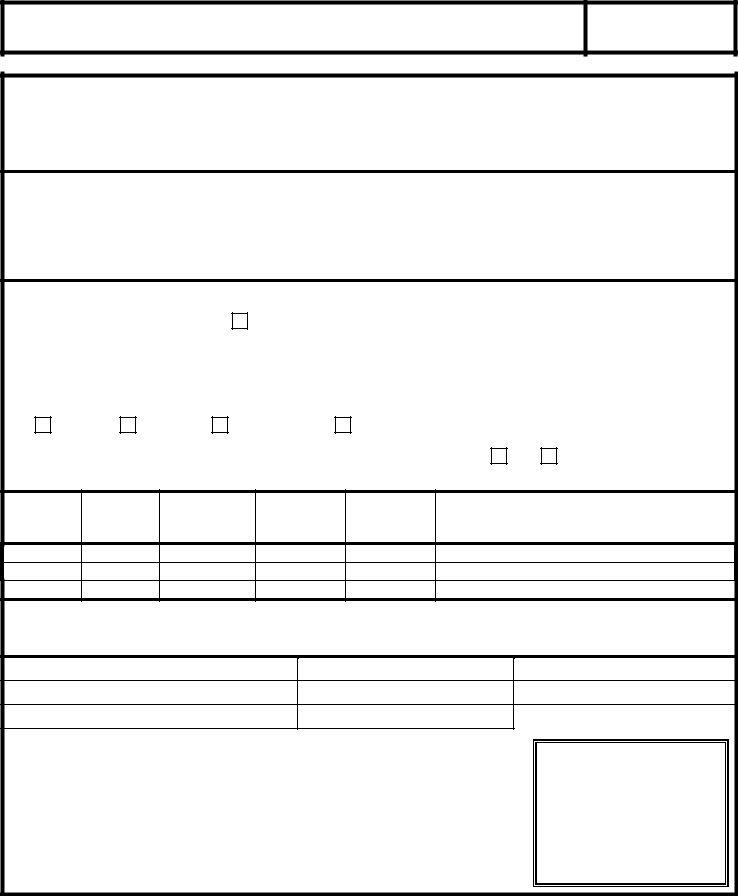
Continued from Page 1.
|
Block |
Lowest Lot |
Lowest |
Base Flood |
|
|
Lot Number |
Adjacent Grade |
For FEMA Use Only |
||||
Number |
Elevation |
Elevation |
||||
|
To Structure |
|
||||
|
|
|
|
|
||
|
|
|
|
|
|
|
|
|
|
|
|
|
|
|
|
|
|
|
|
|
|
|
|
|
|
|
|
|
|
|
|
|
|
|
|
|
|
|
|
|
|
|
|
|
|
|
|
|
|
|
|
|
|
|
|
|
|
|
|
|
|
|
|
|
|
|
|
|
|
|
|
|
|
|
|
|
|
|
|
|
|
|
|
|
|
|
|
|
|
|
|
|
|
|
|
|
|
|
|
|
|
|
|
|
|
|
|
|
|
|
|
|
|
|
|
|
|
|
|
|
|
|
|
|
|
|
|
|
|
|
|
|
|
|
|
|
|
|
|
|
|
|
|
|
|
|
|
|
|
|
|
|
|
|
|
|
|
|
|
|
|
|
|
|
|
|
|
|
|
|
|
|
|
|
|
|
|
|
|
|
|
|
|
|
|
|
|
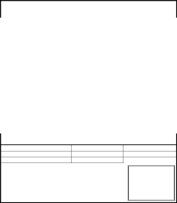
This certification is to be signed and sealed by a licensed land surveyor, registered professional engineer, or architect authorized by law to certify elevation information. All documents submitted in support of this request are correct to the best of my knowledge. I understand that any false statement may be punishable by fine or imprisonment under Title 18 of the United States Code, Section 1001.
Certifier’s Name:
License No.:
Expiration Date:
Company Name:
Telephone No.:
Fax No.:
Signature:
Date:
Seal (optional)
FEMA Form |
Elevation Form |