Navigating the terrain of U.S. federal forms can sometimes resemble an intricate dance of precision and due diligence, particularly when it comes to forms associated with military operations. Among these, the 3823 form emerges as a critical document, encapsulating the airborne units' assumption of responsibility for personnel injury and equipment damage during operations in designated drop zones (DZ). This comprehensive document, readily accessible for download or as a web-optimized version, allows for a meticulous assessment and survey of drop zones, detailing aspects such as the DZ's name, country, state, and precise geographical coordinates. It further delves into the survey approval or disapproval data, including the surveyor's details and the decision-making authority's name and contact information. With its sections on coordinating activities, DZ dimensions, axis data, and ground point elevation, the form serves as a pivotal tool in pre-operation planning and safety assurance. It accords specific attention to the coordination between various agencies and units, underlining the importance of a Memorandum of Understanding concerning land use and range control. In essence, the 3823 form plays an indispensable role in safeguarding personnel and equipment by rigorously defining and reviewing every parameter of drop zones, thus exemplifying the military's commitment to operational excellence and risk management.
| Question | Answer |
|---|---|
| Form Name | 3823 Form |
| Form Length | 2 pages |
| Fillable? | No |
| Fillable fields | 0 |
| Avg. time to fill out | 30 sec |
| Other names | dz disapproval distances online, af form 3823 drop zone survey, 3823 form, air force form 3823 |
This is a
Download the original, full version:
Convert any form into fillable, savable:
www.fillable.com
Learn how to use fillable, savable forms:
Demos: www.fillable.com/demos.html
Examples: www.fillable.com/examples.html
Browse/search 10's of 1000's of U.S. federal forms converted into fillable, savable:
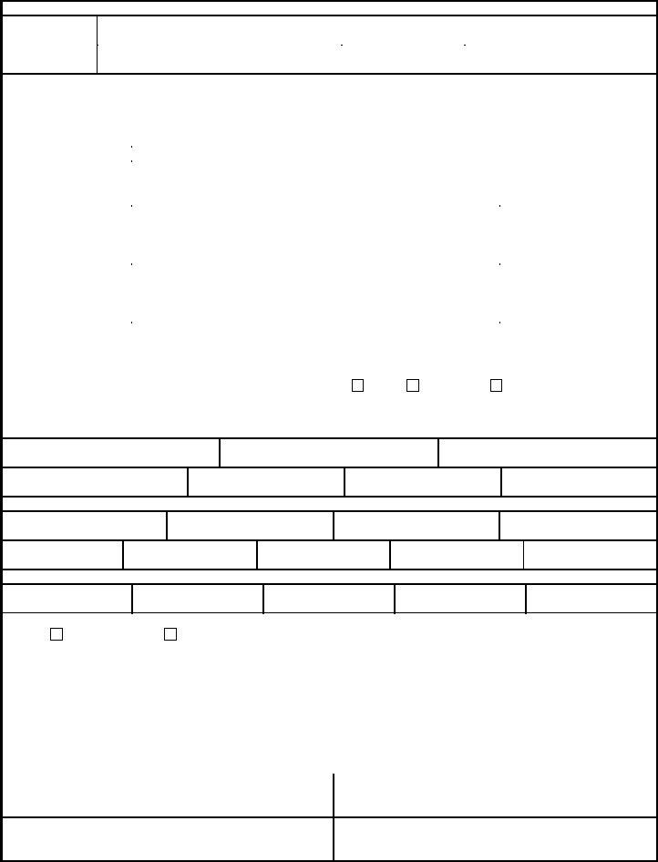
AIRBORNE UNIT ASSUMES RESPONSIBILITY FOR PERSONNEL INJURY AND EQUIPMENT DAMAGE ON DZ
DROP ZONE
SURVEY
1A. DZ NAME |
1B. ZAR INDEX NO. |
2A. COUNTRY |
2B. STATE |
|
|
|
|
3. MAP SERIES/SHEET NUMBER/ EDITION/ DATE OF MAP
4. |
|
|
SURVEY APPROVAL/DISAPPROVAL DATA |
|
|
|
|
|
|
|
|
|
|
|||||||||
4A1. DATE SURVEYED |
4A2. TYPED NAME AND GRADE OF SURVEYOR |
4A3. PHONE NUMBER (DSN) |
4A4. UNIT |
|
|
|
||||||||||||||||
|
|
|
|
|
|
|
|
|
|
|
|
|
|
|
|
|
|
|
|
|
|
|
4B. DROP ZONE |
FOR |
|
CDS/CRL/CRS |
PER |
|
HE |
|
|
MFF |
|
SATB |
|
|
CRRC |
|
HSLLADS |
HVCDS |
|||||
|
|
|
|
|
|
|
|
|
||||||||||||||
APPROVAL/DISAPPROVAL |
|
|
|
|
|
|
|
|
|
|
|
|
|
|
|
|
|
|
|
|
|
|
|
|
|
|
|
|
|
|
|
|
|
|
|
|
|
|
|
|
|
|
|
|
|
A = APPROVED |
DAY |
|
|
|
|
|
|
|
|
|
|
|
|
|
|
|
|
|
|
|
|
|
D = DISAPPROVED |
|
|
|
|
|
|
|
|
|
|
|
|
|
|
|
|
|
|
|
|
|
|
NIGHT |
|
|
|
|
|
|
|
|
|
|
|
|
|
|
|
|
|
|
|
|
||
|
|
|
|
|
|
|
|
|
|
|
|
|
|
|
|
|
||||||
4C. DATE APPROVED |
NAME, GRADE AND SERVICE OF APPROVAL AUTHORITY |
PHONE NUMBER (DSN) |
|
|
SIGNATURE |
|
||||||||||||||||
FOR |
|
|
|
|
|
|
|
|
|
|
|
|
|
|
|
|
|
|
|
|
|
|
|
|
|
|
|
|
|
|
|
|
|
|
|
|
|
|
|
|
|
|
|
|
|
|
UNIT AND LOCATION |
|
|
|
|
|
|
|
|
|
|
|
|
|
|
|
|
|
|
|||
|
|
|
|
|
|
|
|
|
|
|
|
|
|
|
|
|
|
|||||
4D. DATE SAFETY OF |
NAME AND GRADE OF REVIEWING OFFICER |
|
|
PHONE NUMBER (DSN) |
|
|
SIGNATURE |
|
||||||||||||||
FLIGHT REVIEW APPROVED |
|
|
|
|
|
|
|
|
|
|
|
|
|
|
|
|
|
|
|
|
|
|
|
|
|
|
|
|
|
|
|
|
|
|
|
|
|
|
|
|
|
|
|
|
|
|
UNIT AND LOCATION |
|
|
|
|
|
|
|
|
|
|
|
|
|
|
|
|
|
|
|||
|
|
|
|
|
|
|
|
|
|
|
|
|
|
|
|
|
|
|||||
4E. DATE OF MAJCOM |
NAME AND GRADE OF APPROVING AUTHORITY |
|
|
PHONE NUMBER (DSN) |
|
|
SIGNATURE |
|
||||||||||||||
APPROVAL |
|
|
|
|
|
|
|
|
|
|
|
|
|
|
|
|
|
|
|
|
|
|
|
|
|
|
|
|
|
|
|
|
|
|
|
|
|
|
|
|
|
|
|
|
|
|
UNIT AND LOCATION |
|
|
|
|
|
|
|
|
|
|
|
|
|
|
|
|
|
|
|||
|
|
|
|
|
|
|
|
|
|
|
|
|
|
|
|
|
|
|
|
|||
5. |
|
|
|
COORDINATING ACTIVITIES |
|
|
|
|
|
|
|
|
|
|
||||||||
A. DZ CONTROLLING AGENCY OR UNIT |
|
|
B. MEMORANDUM OF UNDERSTANDING/LAND USE |
|
|
|
|
C. PHONE NUMBER (DSN) |
||||||||||||||
|
|
|
|
|
YES |
|
|
NO |
|
|
ATTACHED |
|
|
|
|
|
|
|
||||
|
|
|
|
|
|
|
|
|
|
|
|
|
|
|
|
|||||||
|
|
|
|
|
|
|
|
|
|
|
|
|
|
|
|
|
|
|
|
|
|
|
|
|
|
|
|
|
|
|
|
|
|
|
|
|
|
|
|
|
|
|
|
|
|
D. RANGE CONTROL |
|
|
|
|
|
|
|
|
|
|
|
|
|
|
|
|
|
|
|
E. PHONE NUMBER (DSN) |
||
|
|
|
|
|
|
|
|
|
|
|
|
|
|
|
|
|
|
|
||||
6. |
|
DZ DIMENSIONS (YDS/MTRS) (FOR CIRCULAR DZ, ENTER RADIUS ONLY) |
|
|
|
|
|
|
|
|||||||||||||
A. LENGTH
B. WIDTH
C. RADIUS
POINT OF IMPACT DISTANCES FROM DZ
LEADING EDGE
D. CDS PI
E. PE PI
F. HE PI
7. |
DZ AXIS DATA (OPTIONAL FOR CIRCULAR DZ) |
A. MAGNETIC
B. GRID (MGRS)
C. TRUE
D. SOURCE/DATE OF VARIATION DATA
8.GROUND POINT ELEVATION
A. CDS PI
B. HE PI
C. PE PI
D. HIGHEST
9. |
DZ COORDINATES |
A. SPHEROID
B. DATUM
C. GRID ZONE
D. EASTING
E. NORTHING
F. GPS DERIVED COORDINATES |
|
|
G. POINT OF ORIGIN |
|
||||||
|
|
|
|
|
|
|
|
|
|
|
YES |
|
|
|
NO |
|
|
|
|
|
|
|
|
|
|
|
|
|
|
|
|
|
|
|
|
|
|
|
|
||||
H. POINT |
|
MGRS COORDINATES |
|
WGS84 LATITUDE |
WGS84 LONGITUDE |
|||||
|
|
|
|
|
|
|
|
|
||
DZ |
|
|
|
|
|
|
|
|
||
CENTERPOIN |
|
|
|
|
|
|
|
|
||
|
|
|
|
|
|
|
|
|
||
CDS PI |
|
|
|
|
|
|
|
|
||
|
|
|
|
|
|
|
|
|
||
PE PI |
|
|
|
|
|
|
|
|
||
|
|
|
|
|
|
|
|
|
||
HE PI |
|
|
|
|
|
|
|
|
||
|
|
|
|
|
|
|
|
|
||
I. |
|
|
|
|
DZ CORNERS MGRS COORDINATES |
|
||||
LEFT LEADING EDGE |
|
|
|
|
|
RIGHT LEADING EDGE |
|
|||
LEFT TRAILING EDGE
RIGHT TRAILING EDGE
AF IMT 3823, 20021001, V2
PREVIOUS EDITIONS ARE OBSOLETE.