Fema Form Mt 1 PDF Details

Fema Form Mt 1 is a mandatory form that all businesses must complete in order to be registered with FEMA. The form can be completed online or by mail, and it's important to submit it as soon as possible to ensure you are eligible for disaster relief funds if needed. This form asks for specific information about your business, including its name, address, and contact info. Completing Fema Form Mt 1 is the first step in establishing your business' relationship with FEMA.

QuestionAnswer
Form NameFema Form Mt 1
Form Length6 pages
Fillable?No
Fillable fields0
Avg. time to fill out1 min 30 sec
Other namesform mt 1 form, form mt 1, fema form mt ez, fema elevation form mt 1

Form Preview Example

DEPARTMENT OF HOMELAND SECURITY - FEDERAL EMERGENCY MANAGEMENT AGENCY

PROPERTY INFORMATION FORM

O.M.B. NO. 1660-0015

Expires February 28, 2014

PAPERWORK BURDEN DISCLOSURE NOTICE

Public reporting burden for this data collection is estimated to average 1.63 hours per response. The burden estimate includes the time for reviewing instructions, searching existing data sources, gathering and maintaining the needed data, and completing and submitting the form. This collection is required to obtain or retain benefits. You are not required to respond to this collection of information unless a valid OMB control number is displayed on this form. Send comments regarding the accuracy of the burden estimate and any suggestions for reducing this burden to: Information Collections Management, Department of Homeland Security, Federal Emergency Management Agency, 1800 South Bell Street, Arlington, VA 20598-3005, Paperwork Reduction Project (1660-0015). NOTE: Do not send your completed form to this address.

This form may be completed by the property owner, property owner’s agent, licensed land surveyor, or registered professional engineer to support a request for a Letter of Map Amendment (LOMA), Conditional Letter of Map Amendment (CLOMA), Letter of Map Revision Based on Fill (LOMR-F), or Conditional Letter of Map Revision Based on Fill (CLOMR-F) for existing or proposed, single or multiple lots/structures. In order to process your request, all information on this form must be completed in its entirety, unless stated as optional. Incomplete submissions will result in processing delays. Please check the item below that describes your request:

LOMA

CLOMA

LOMR-F

CLOMR-F

A letter from DHS-FEMA stating that an existing structure or parcel of land that has not been elevated by fill (natural grade) would not be inundated by the base flood.

A letter from DHS-FEMA stating that a proposed structure that is not to be elevated by fill (natural grade) would not be inundated by the base flood if built as proposed.

A letter from DHS-FEMA stating that an existing structure or parcel of land that has been elevated by fill would not be inundated by the base flood.

A letter from DHS-FEMA stating that a parcel of land or proposed structure that will be elevated by fill would not be inundated by the base flood if fill is placed on the parcel as proposed or the structure is built as proposed.

Fill is defined as material from any source (including the subject property) placed that raises the ground to or above the Base Flood Elevation (BFE). The common construction practice of removing unsuitable existing material (topsoil) and backfilling with select structural material is not considered the placement of fill if the practice does not alter the existing (natural grade) elevation, which is at or above the BFE. Fill that is placed before the date of the first National Flood Insurance

Program (NFIP) map showing the area in a Special Flood Hazard Area (SFHA) is considered natural grade.

Has fill been placed on your property to raise ground that was previously below the BFE?

Will fill be placed on your property to raise ground that is below the BFE?

Yes

No

If yes, when was fill placed?


mm/dd/yyyy

Yes*

No

If yes, when will fill be placed?


mm/dd/yyyy

*If yes, Endangered Species Act (ESA) compliance must be documented to FEMA prior to issuance of the CLOMR-F determination (please refer page 4 to the MT-1 instructions).

1.Street Address of the Property (if request is for multiple structures or units, please attach additional sheet referencing each address and enter street names below):

2.Legal description of Property (Lot, Block, Subdivision or abbreviated description from the Deed):

3.Are you requesting that a flood zone determination be completed for (check one):

Structures on the property? What are the dates of construction? _______________ (MM/YYYY)

A portion of land within the bounds of the property? (A certified metes and bounds description and map of the area to be removed, certified by a licensed land surveyor or registered professional engineer, are required. For the preferred format of metes and bounds descriptions, please refer to the MT-1 Form 1 Instructions.)

The entire legally recorded property?

4.Is this request for a (check one):

Single structure

Single lot

Multiple structures (How many structures are involved in your request? List the number: _______)

Multiple lots (How many lots are involved in your request? List the number: _______)

DHS - FEMA Form 086-0-26, FEB 11

Property Information Form

MT-1 Form 1 Page 1 of 2

In addition to this form (MT-1 Form 1), please complete the checklist below. ALL requests must include one copy of the following:

Copy of the effective FIRM panel on which the structure and/or property location has been accurately plotted (property inadvertently located in the NFIP regulatory floodway will require Section B of MT-1 Form 3)

Copy of the Subdivision Plat Map for the property (with recordation data and stamp of the Recorder’s Office)

OR

Copy of the Property Deed (with recordation data and stamp of the Recorder’s Office), accompanied by a tax assessor’s map or other certified map showing the surveyed location of the property relative to local streets and watercourses. The map should include at least one street intersection that is shown on the FIRM panel.

Form 2 Elevation Form. If the request is to remove the structure, and an Elevation Certificate has already been completed for this property, it may be submitted in lieu of Form 2. If the request is to remove the entire legally recorded property, or a portion thereof, the lowest lot elevation must be provided on Form 2.

Please include a map scale and North arrow on all maps submitted.

For LOMR-Fs and CLOMR-Fs, the following must be submitted in addition to the items listed above:

Form 3 Community Acknowledgment Form

For CLOMR-Fs, the following must be submitted in addition to the items listed above:

Documented ESA compliance, which may include a copy of an Incidental Take Permit, an Incidental Take Statement, a “not likely to adversely affect”

determination from the National Marine Fisheries Service (NMFS) or the U.S. Fish and Wildlife Service (USFWS), or an official letter from NMFS or USFWS concurring that the project has “No Effect” on proposed or listed species or designated critical habitat/ Please refer to the MT-1 instructions for additional

information.

Please do not submit original documents. Please retain a copy of all submitted documents for your records.

DHS-FEMA encourages the submission of all required data in a digital format (e.g. scanned documents and images on Compact Disc [CD]). Digital submissions help to further DHS-FEM!’s Digital Vision and also may facilitate the processing of your request.

Incomplete submissions will result in processing delays. For additional information regarding this form, including where to obtain the supporting documents listed above, please refer to the MT-1 Form Instructions located at http://www.fema.gov/plan/prevent/fhm/dl_mt-1.shtm.

Processing Fee (see instructions for appropriate mailing address; or visit http://www.fema.gov/fhm/frm_fees.shtm for the most current fee schedule)

Revised fee schedules are published periodically, but no more than once annually, as noted in the Federal Register. Please note: single/multiple lot(s)/structure(s) LOMAs are fee exempt. The current review and processing fees are listed below:

Check the fee that applies to your request:

$325 (single lot/structure LOMR-F following a CLOMR-F)

$425 (single lot/structure LOMR-F)

$500 (single lot/structure CLOMA or CLOMR-F)

$700 (multiple lot/structure LOMR-F following a CLOMR-F, or multiple lot/structure CLOMA)

$800 (multiple lot/structure LOMR-F or CLOMR-F)

Please submit the Payment Information Form for remittance of applicable fees. Please make your check or money order payable to:

National Flood Insurance Program.

All documents submitted in support of this request are correct to the best of my knowledge. I understand that any false statement may be punishable by fine or imprisonment under Title 18 of the United States Code, Section 1001.

!pplicant’s Name (required).

Mailing Address (required):

E-Mail Address (optional):

By checking here you may receive

correspondence electronically at the email address provided):

Date (required)

Company (if applicable):

Daytime Telephone No. (required):

Fax No. (optional):

___________________________________________________________

Signature of Applicant (required)

DHS - FEMA Form 086-0-26, FEB 11

Property Information Form

MT-1 Form 1 Page 2 of 2

DEPARTMENT OF HOMELAND SECURITY - FEDERAL EMERGENCY MANAGEMENT AGENCY

ELEVATION FORM

O.M.B. NO. 1660-0015

Expires February 28, 2014

PAPERWORK BURDEN DISCLOSURE NOTICE

Public reporting burden for this data collection is estimated to average 1.25 hours per response. The burden estimate includes the time for reviewing instructions, searching existing data sources, gathering and maintaining the needed data, and completing and submitting the form. This collection is required to obtain or retain benefits. You are not required to respond to this collection of information unless a valid OMB control number is displayed on this form. Send comments regarding the accuracy of the burden estimate and any suggestions for reducing this burden to: Information Collections Management, Department of Homeland Security, Federal Emergency Management Agency, 1800 South Bell Street, Arlington, VA 20598-3005, Paperwork Reduction Project (1660-0015). NOTE: Do not send your completed

form to this address.

This form must be completed for requests and must be completed and signed by a registered professional engineer or licensed land surveyor. A DHS - FEMA National

Flood Insurance Program (NFIP) Elevation Certificate may be submitted in lieu of this form for single structure requests.

For requests to remove a structure on natural grade OR on engineered fill from the Special Flood Hazard Area (SFHA), submit the lowest adjacent grade (the lowest ground touching the structure), including an attached deck or garage. For requests to remove an entire parcel of land from the SFHA, provide the lowest lot elevation; or, if the request involves an area described by metes and bounds, provide the lowest elevation within the metes and bounds description. All measurements are to be rounded to nearest tenth of a foot. In order to process your request, all information on this form must be completed in its entirety. Incomplete submissions will

result in processing delays.

1. NFIP Community Number:

Property Name or Address:

2.Are the elevations listed below based on

existing or

proposed conditions? (Check one)

3.For the existing or proposed structures listed below, what are the types of construction? (check all that apply)

crawl space

slab on grade

basement/enclosure

other (explain)

4.Has DHS - FEMA identified this area as subject to land subsidence or uplift? (see instructions)

If yes, what is the date of the current re-leveling?

/

(month/year)

Yes

No

5. What is the elevation datum? NGVD 29

NAVD 88

Other (explain)

If any of the elevations listed below were computed using a datum different than the datum used for the effective Flood Insurance Rate Map (FIRM) (e.g., NGVD 29 or NAVD 88), what was the conversion factor?

Local Elevation +/- ft. = FIRM Datum

6.Please provide the Latitude and Longitude of the most upstream edge of the structure (in decimal degrees to the nearest fifth decimal place):

Indicate Datum:

WGS84

NAD83

NAD27 Lat.

.

Long.

.

Please provide the Latitude and Longitude of the most upstream edge of the property (in decimal degrees to the nearest fifth decimal place):

Indicate Datum:

WGS84

NAD83

NAD27 Lat.

.

Long.

.

Address

Lot Number

Block

Number

Lowest Lot Elevation*

Lowest

Adjacent

Grade To

Structure

Base Flood

Elevation

BFE Source

This certification is to be signed and sealed by a licensed land surveyor, registered professional engineer, or architect authorized by law to certify elevation information. All documents submitted in support of this request are correct to the best of my knowledge. I understand that any false statement may be punishable by fine or imprisonment under Title 18 of the United States Code, Section 1001.

ertifier’s Name.

License No.:

Expiration Date:


Company Name:

Telephone No.:


Email:

Fax No.

Signature:

Date:

* For requests involving a portion of property, include the lowest ground elevation within

the metes and bounds description.Seal (optional) Please note: If the Lowest Adjacent Grade to Structure is the only elevation provided, a determination

will be issued for the structure only.

DHS - FEMA Form 086-0-26A, FEB 11

Elevation Form

MT-1 Form 2 Page 1 of 2

Continued from Page 1.

Address

Lot Number

Block Number

Lowest Lot Elevation*

Lowest Adjacent

Grade To

Structure

Base Flood

Elevation

BFE Source

This certification is to be signed and sealed by a licensed land surveyor, registered professional engineer, or architect authorized by law to certify elevation information. All documents submitted in support of this request are correct to the best of my knowledge. I understand that any false statement may be punishable by fine or imprisonment under Title 18 of the United States Code, Section 1001.

ertifier’s Name.

License No.:

Expiration Date:

Company Name:

Telephone No.:

Email:

Fax No.

Signature:

Date:

* For requests involving a portion of property, include the lowest ground elevation within

the metes and bounds description.Seal (optional) Please note: If the Lowest Adjacent Grade to Structure is the only elevation provided, a

determination will be issued for the structure only.

DHS - FEMA Form 086-0-26A, FEB 11

Elevation Form

MT-1 Form 2 Page 2 of 2

DEPARTMENT OF HOMELAND SECURITY - FEDERAL EMERGENCY MANAGEMENT AGENCY

COMMUNITY ACKNOWLEDGMENT FORM

O.M.B. NO. 1660-0015

Expires February 28, 2014

PAPERWORK BURDEN DISCLOSURE NOTICE

Public reporting burden for this data collection is estimated to average 1.38 hours per response. The burden estimate includes the time for reviewing instructions, searching existing data sources, gathering and maintaining the needed data, and completing and submitting the form. This collection is required to obtain or retain benefits. You are not required to respond to this collection of information unless a valid OMB control number is displayed on this form. Send comments regarding the accuracy of the burden estimate and any suggestions for reducing this burden to: Information Collections Management, Department of Homeland Security, Federal Emergency Management Agency, 1800 South Bell Street, Arlington, VA 20598-3005, Paperwork Reduction Project (1660-0015). NOTE: Do not send your completed form to this address.

This form must be completed for requests involving the existing or proposed placement of fill (complete Section A) OR to provide acknowledgment of this request to remove a property from the SFHA which was previously located within the regulatory floodway (complete Section B).

This form must be completed and signed by the official responsible for floodplain management in the community. The six digit NFIP community number and the subject property address must appear in the spaces provided below. Incomplete submissions will result in processing delays. Please refer to the MT-1 instructions for additional information about this form.

Community Number: ____________________

Property Name or Address: ____________________________________________

A. REQUESTS INVOLVING THE PLACEMENT OF FILL

As the community official responsible for floodplain management, I hereby acknowledge that we have received and reviewed this Letter of Map Revision Based on Fill (LOMR-F) or Conditional LOMR-F request. Based upon the community's review, we find the completed or proposed project meets or is designed to meet all of the community floodplain management requirements, including the requirement that no fill be placed in the regulatory floodway, and that all necessary Federal, State, and local permits have been, or in the case of a Conditional LOMR-F, will be obtained. For Conditional LOMR-F requests, the applicant has or will document Endangered Species Act (ESA) compliance to FEMA prior to issuance of the

Conditional LOMR-F determination. For LOMR-F requests, I acknowledge that compliance with Sections 9 and 10 of the ESA has been achieved independently of FEM!’s process/ Section 9 of the ES! prohibits anyone from “taking” or harming an endangered species/ If an action might harm

an endangered species, a permit is required from U.S. Fish and Wildlife Service or National Marine Fisheries Service under Section 10 of the ESA. For actions authorized, funded, or being carried out by Federal or State agencies, documentation from the agency showing its compliance with Section 7(a)(2) of the ESA will be submitted. In addition, we have determined that the land and any existing or proposed structures to be removed from the SFHA are or will be reasonably safe from flooding as defined in 44CFR 65.2(c), and that we have available upon request by DHS-FEMA, all analyses and documentation used to make this determination. For LOMR-F requests, we understand that this request is being forwarded to DHS- FEMA for a possible map revision.

Community Comments:

ommunity Official’s Name and Title. (Please Print or Type)

Telephone No.:


Community Name:

ommunity Official’s Signature. (required)

Date:


B. PROPERTY LOCATED WITHIN THE REGULATORY FLOODWAY

As the community official responsible for floodplain management, I hereby acknowledge that we have received and reviewed this request for a LOMA. We understand that this request is being forwarded to DHS-FEMA to determine if this property has been inadvertently included in the regulatory floodway. We acknowledge that no fill on this property has been or will be placed within the designated regulatory floodway. We find that the completed or proposed project meets or is designed to meet all of the community floodplain management requirements.

Community Comments:

ommunity Official’s Name and Title. (Please Print or Type)

Telephone No.:


Community Name:

ommunity Official’s Signature (required).

Date:


DHS - FEMA Form 086-0-26B, FEB 11

Community Acknowledgment Form

MT-1 Form 3 Page 1 of 1

FEDERAL EMERGENCY MANAGEMENT AGENCY

PAYMENT INFORMATION FORM

Community Name:

Project Identifier:

THIS FORM MUST BE MAILED, ALONG WITH THE APPROPRIATE FEE, TO THE ADDRESS BELOW OR FAXED TO THE FAX NUMBER BELOW.

Please make check or money order payable to the National Flood Insurance Program.

Type of Request:

LOMC Clearinghouse

MT-1 application

847 South Pickett Street

MT-2 application

Alexandria, VA 22304-4605


Attn.: LOMC Manager


FEMA Project Library


EDR application


847 South Pickett Street


Alexandria, VA 22304-4605


FAX (703) 212-4090


Request No. (if known):

_______________


Check No.:

_______________


Amount:

INITIAL FEE*

FINAL FEE

FEE BALANCE**

MASTER CARD

VISA

CHECK

MONEY ORDER

*Note: Check only for EDR and/or Alluvial Fan requests (as appropriate).

**Note: Check only if submitting a corrected fee for an ongoing request.

COMPLETE THIS SECTION ONLY IF PAYING BY CREDIT CARD

CARD NUMBER

EXP. DATE

1 2 3 4

5 6 7 8

9 10 11 12

13 14 15 16

Month

Year


_________________________________________________________________


Date


Signature


NAME (AS IT APPEARS ON CARD):

(please print or type)

ADDRESS: (for your credit card receipt-please print or type)

DAYTIME PHONE:

FEMA Form 81-107

Payment Information Form

How to Edit Fema Form Mt 1 Online for Free

With the help of the online editor for PDFs by FormsPal, you're able to complete or change fema mt 1 form 3 page 5 here and now. To have our editor on the forefront of practicality, we strive to put into operation user-driven capabilities and improvements regularly. We are routinely looking for feedback - play a pivotal part in remolding the way you work with PDF docs. For anyone who is seeking to get going, here's what you will need to do:

Step 1: Just hit the "Get Form Button" at the top of this site to open our pdf editing tool. Here you'll find everything that is required to fill out your document.

Step 2: With the help of our online PDF editing tool, it is possible to do more than merely complete forms. Edit away and make your docs seem perfect with custom text incorporated, or tweak the file's original content to perfection - all that comes with an ability to add stunning images and sign it off.

This document needs some specific details; in order to ensure correctness, don't hesitate to take note of the subsequent tips:

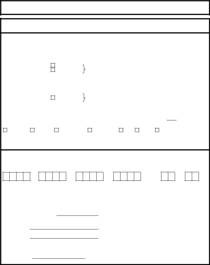
1. First of all, once filling in the fema mt 1 form 3 page 5, start with the part that features the next blanks:

fema mt 1 completion process detailed (step 1)

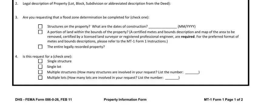
2. After this segment is done, it is time to include the essential details in Legal description of Property Lot, Are you requesting that a flood, Structures on the property What, A portion of land within the, The entire legally recorded, Is this request for a check one, Single lot, Multiple structures How many, Multiple lots How many lots are, DHS FEMA Form FEB, Property Information Form, and MT Form Page of in order to move on further.

Multiple structures How many, DHS  FEMA Form  FEB, and Are you requesting that a flood of fema mt 1

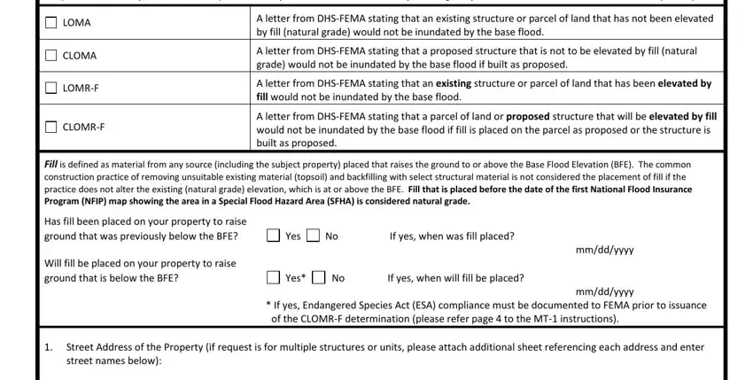
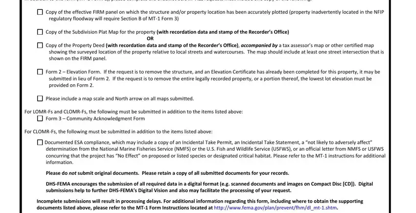
3. This third section is usually relatively uncomplicated, In addition to this form MT Form, Copy of the effective FIRM panel, regulatory floodway will require, Copy of the Subdivision Plat Map, Copy of the Property Deed with, Form Elevation Form If the, Please include a map scale and, For LOMRFs and CLOMRFs the, Form Community Acknowledgment, For CLOMRFs the following must be, Documented ESA compliance which, Please do not submit original, DHSFEMA encourages the submission, and Incomplete submissions will result - all of these blanks needs to be completed here.

Stage no. 3 for filling out fema mt 1

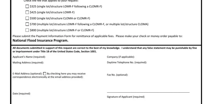
4. The next part needs your information in the subsequent parts: Check the fee that applies to your, single lotstructure LOMRF, single lotstructure LOMRF, single lotstructure CLOMA or, multiple lotstructure LOMRF, multiple lotstructure LOMRF or, Please submit the Payment, All documents submitted in support, pplicants Name required, Mailing Address required, EMail Address optional, By checking here you may receive, Date required, Company if applicable, and Daytime Telephone No required. Make sure that you enter all requested info to move onward.

fema mt 1 completion process explained (stage 4)

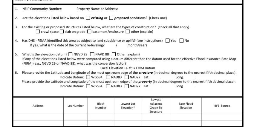
5. The document must be finalized by filling in this area. Here there can be found an extensive list of blanks that need specific information for your form submission to be accomplished: For requests to remove a structure, Property Name or Address, NFIP Community Number, Are the elevations listed below, existing or, proposed conditions Check one, For the existing or proposed, crawl space, basementenclosure, other explain, slab on grade, Has DHS FEMA identified this, If yes what is the date of the, Other explain, and monthyear.

Completing section 5 in fema mt 1

Many people generally make mistakes when filling in For requests to remove a structure in this part. Don't forget to review everything you enter here.

Step 3: Proofread the details you've inserted in the blank fields and click on the "Done" button. Try a 7-day free trial subscription at FormsPal and gain immediate access to fema mt 1 form 3 page 5 - which you can then work with as you wish inside your personal cabinet. With FormsPal, you're able to fill out forms without stressing about database breaches or entries being distributed. Our protected software makes sure that your private data is kept safe.