Name ____________________________ Period ______ Date ________________
Topographic Map Reading Worksheet
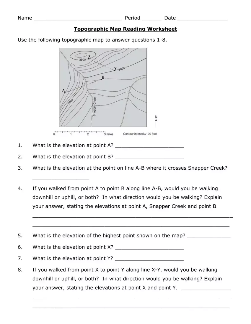
Use the following topographic map to answer questions 1-8.
1.What is the elevation at point A? ______________________
2.What is the elevation at point B? ______________________
3.What is the elevation at the point on line A-B where it crosses Snapper Creek?
__________________
4.If you walked from point A to point B along line A-B, would you be walking downhill or uphill, or both? In what direction would you be walking? Explain your answer, stating the elevations at point A, Snapper Creek and point B.
________________________________________________________________
_______________________________________________________________
5.What is the elevation of the highest point shown on the map? ______________
6.What is the elevation at point X? ______________________
7.What is the elevation at point Y? ______________________
8.If you walked from point X to point Y along line X-Y, would you be walking downhill or uphill, or both? In what direction would you be walking? Explain your answer, stating the elevations at point X and point Y. ________________
_______________________________________________________________
_______________________________________________________________
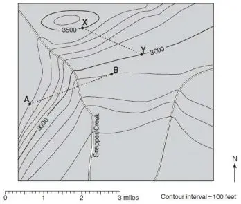
Use the following topographic map from Palo Duro Canyon State Park in west Texas to answer questions 9 - 33.
•C |
|
|
|
|
|
|
|
G• |
|
|
|
|
|
Prairie |
|
|
|
|
|
|
|
|
|
Dog |
|
|
|
1000 |
|
|
|
|
|
|
|
|
|
|
|
|
|
|
Town |
|
900 |
|
•B |
|
|
|
|
|
Fork |
|
|
|
|
|
|
|
|
•A |
|
|
|
|
|
|
|
|
Red |
|
|
|
|
|
|
|
|
|
|
|
|
|
|
|
Goodnight Peak |
River |
|
|
|
|
|
|
|
|
|
|
|
|
|
|
|
|
•F |
|
|
|
1000 |
|
|
|
|
|
|
|
|
|
|
•J |
900 |
950 |
•L |
|
|
1000 |
Brushy Butte |
•E |
|
|
|
|
|
|
|
|
|
|
|
|
|
|
|
950 |
|
|
|
|
|
|
|
|
900 |
•K |
|
|
|
|
|
|
|
|
|
N |
|
|
|
|
H• |
|
|
|
|
|
|
|
900 |
|
•D |
|
|
|
|
|
|
|
|
|
|
|
|
|
Contour Interval = 10 meters
 1.0 km
9.What is the elevation of Goodnight Peak? ___________________________
10.What is the elevation of Brushy Butte? __________________________
11.What is the elevation of point A? ________________________
12.What is the elevation of point B? ________________________
13.If you walked along the creek from point A to point B, what would be the total change in elevation? __________________________ In what direction would you be walking? ______________________
14.What is the elevation of point C? ________________________
15.What is the elevation of point D? ______________________
16.What is the elevation of point E? ______________________
17.What is the elevation of point F? ______________________
18.What is the elevation of point G? ______________________
19.What is the elevation of point H? ______________________
20.What is the elevation of point J? ______________________
21.If you walked along the creek from point H to point J, what would be the total change in elevation? __________________________ In what direction would you be walking? ______________________
22.What is the lowest labeled point on the map? ___________________
23.What is the highest labeled point on the map? ___________________
24.In what direction is the river at the center of the map flowing? ____________
25.Put a small star on the map where the slope is the steepest.
26.Put a small triangle on the map where the slope is the flattest.
27.Is point K in a valley or a ridge? _____________________
28.Is point L in a valley or a ridge? _____________________
29.What is the distance from point A to point F, to the nearest tenth of a kilometer?
__________________
30.What is the distance from point H to point D, to the nearest tenth of a kilometer? __________________
31.What is the distance from point B to point E, to the nearest tenth of a kilometer? __________________
32.What is the distance from Goodnight Peak to point L, to the nearest tenth of a kilometer? __________________
33.If you could travel in time and visit the park shown on the map 100,000 years in the future, what changes do you think will have taken place to the elevations of Goodnight Peak and Brushy Butte? Explain your answer. __________________
________________________________________________________________
________________________________________________________________
________________________________________________________________