

FEMA Form FF-206-FY-22-152 at a glance
What it is: The National Flood Insurance Program Elevation Certificate is an important administrative tool of the NFIP.
Who signs: In Section D, the certification is to be signed and sealed by a land surveyor, engineer, or architect authorized by state law to certify elevation information.
The Elevation Certificate can be used to provide elevation information necessary to ensure compliance with community floodplain management ordinances, to inform the proper insurance premium, and to support a request for a LOMA, CLOMA, LOMR-F, or CLOMR-F.
The Elevation Certificate is used to document floodplain management compliance for Post-Flood Insurance Rate Map (FIRM) buildings, which are buildings constructed after publication of the FIRM, located in flood Zones A1-A30, AE, AH, AO, A (with Base Flood Elevation (BFE)), VE, V1-V30, V (with BFE), AR, AR/A, AR/AE, AR/A1-A30, AR/AH, AR/AO, and A99.
It may also be used to provide elevation information for Pre-FIRM buildings or buildings in any flood zone.
What to bring and attach to FEMA Form FF-206-FY-22-152
You must follow the instructions on instruction pages 1-11. Copy all pages of this Elevation Certificate and all attachments for (1) community official, (2) insurance agent/company, and (3) building owner.
Attach at least two and when possible four clear color photographs (one for each side) of the building (see Form pages 7 and 8).
A filled-in FEMA Form FF-206-FY-22-152 example: an owner fills in Sections A and B for a house
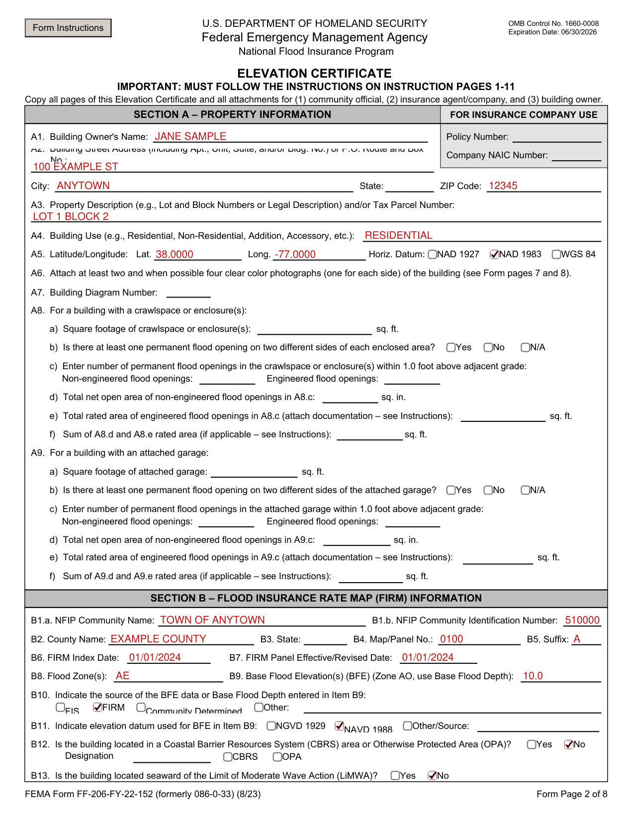
How to fill out FEMA Form FF-206-FY-22-152, box by box
A1 to A4, Building Owner's Name, Building Street Address, Property Description and Building Use
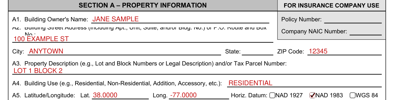
In A1, enter the Building Owner's Name; in A2, the Building Street Address (including Apt., Unit, Suite, and/or Bldg. No.) or P.O. Route and Box No., City, State and ZIP Code; in A3, the Property Description (e.g., Lot and Block Numbers or Legal Description) and/or Tax Parcel Number; in A4, the Building Use (e.g., Residential, Non-Residential, Addition, Accessory, etc.).
A5 to A7, Latitude/Longitude, Datum and Building Diagram Number

In A5, enter the Latitude/Longitude: Lat. and Long., and check the Horiz. Datum: NAD 1927, NAD 1983 or WGS 84.
Enter the Building Diagram Number.
A8 and A9, a building with a crawlspace, enclosure(s) or an attached garage
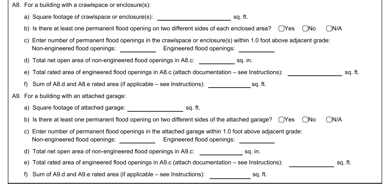
For a building with a crawlspace or enclosure(s), enter the Square footage of crawlspace or enclosure(s) in sq. ft. and check No or Yes (or N/A): Is there at least one permanent flood opening on two different sides of each enclosed area?
For a building with an attached garage, enter the Square footage of attached garage in sq. ft. and check Yes, No or N/A for: Is there at least one permanent flood opening on two different sides of the attached garage?
B1 to B9, Flood Insurance Rate Map (FIRM) Information

In B1.a, enter the NFIP Community Name and in B1.b the NFIP Community Identification Number; then enter the County Name, State, Map/Panel No., Suffix, FIRM Index Date, FIRM Panel Effective/Revised Date, Flood Zone(s), and the Base Flood Elevation(s) (BFE) (Zone AO, use Base Flood Depth).
B10 to B13, the source and datum of the BFE, CBRS or OPA, and LiMWA

Indicate the source of the BFE data or Base Flood Depth entered in Item B9: FIS, FIRM, Community Determined or Other.
Indicate elevation datum used for BFE in Item B9: NGVD 1929, NAVD 1988 or Other/Source.
Check Yes or No: Is the building located in a Coastal Barrier Resources System (CBRS) area or Otherwise Protected Area (OPA)? Designation: CBRS or OPA. Check Yes or No: Is the building located seaward of the Limit of Moderate Wave Action (LiMWA)?
C1, Building elevations are based on
In C1, check the Building elevations are based on: Construction Drawings*, Building Under Construction* or Finished Construction; *a new Elevation Certificate will be required when construction of the building is complete.
C2, Benchmark, Vertical Datum and conversion factor
For Zones A1-A30, AE, AH, AO, A (with BFE), VE, V1-V30, V (with BFE), AR, AR/A, AR/AE, AR/A1-A30, AR/AH, AR/AO, and A99, complete Items C2.a-h according to the Building Diagram specified in Item A7. In Puerto Rico only, enter meters.
Enter the Benchmark Utilized. Indicate elevation datum used for the elevations in items a) through h): NGVD 1929, NAVD 1988 or Other. Datum used for building elevations must be the same as that used for the BFE.
Conversion factor used? Check Yes or No. If Yes, describe the source of the conversion factor in the Section D Comments area.
C2.a to C2.h, the measurements used
Check the measurement used, feet or meters, for: a) Top of bottom floor (including basement, crawlspace, or enclosure floor); b) Top of the next higher floor (see Instructions); c) Bottom of the lowest horizontal structural member (see Instructions); d) Attached garage (top of slab).
Check feet or meters for: e) Lowest elevation of Machinery and Equipment (M&E) servicing the building (describe type of M&E and location in Section D Comments area); f) Lowest Adjacent Grade (LAG) next to building: Natural or Finished; g) Highest Adjacent Grade (HAG) next to building: Natural or Finished; h) Finished LAG at lowest elevation of attached deck or stairs, including structural support.
Section D, the certification
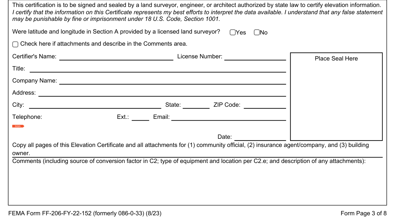
The certifier certifies the information on this Certificate represents the certifier's best efforts to interpret the data available.
Any false statement may be punishable by fine or imprisonment under 18 U.S. Code, Section 1001.
Check Yes or No: Were latitude and longitude in Section A provided by a licensed land surveyor? Check here if attachments and describe in the Comments area.
Enter the Certifier's Name, License Number, Title, Company Name, Address, City, State, ZIP Code, Ext., Email and Telephone, place the seal at Place Seal Here and sign at SIGN.
In Comments, include the source of conversion factor in C2; type of equipment and location per C2.e; and description of any attachments.
Section E, Building Measurement Information for Zone AO, Zone AR/AO and Zone A (without BFE)
For Zones AO, AR/AO, and A (without BFE), complete Items E1-E5. For Items E1-E4, use natural grade, if available.
Section G, Community Information, local official
In Section G, the local official who is authorized by law or ordinance to administer the community's floodplain management ordinance can complete Section A, B, C, E, G, or H of this Elevation Certificate.
Section H, Building's First Floor Height Information
In Section H, the property owner, owner's authorized representative, or local floodplain management official may complete Section H for all flood zones to determine the building's first floor height for insurance purposes. Sections A, B, and I must also be completed.
Building Photographs
Identify all photographs with the date taken and "Front View," "Rear View," "Right Side View," or "Left Side View." Photographs must show the foundation. When flood openings are present, include at least one close-up photograph of representative flood openings or vents, as indicated in Sections A8 and A9.
Building Photographs, Continuation Page
Insert the third and fourth photographs.
More rules for FEMA Form FF-206-FY-22-152
A completed Elevation Certificate does not expire, unless there is a physical change to the building that invalidates information in Section A Items A8 or A9, Section C, Section E, or Section H.
A LOMA, CLOMA, LOMR-F, or CLOMR-F request
LOMA, CLOMA, LOMR-F, or CLOMR-F request
The Elevation Certificate may be used to support a LOMA, CLOMA, LOMR-F, or CLOMR-F request. Lowest Adjacent Grade (LAG) elevations certified by a land surveyor, engineer, or architect, as authorized by state law, will be required if the certificate is used to support a LOMA, CLOMA, LOMR-F, or CLOMR-F request.
Submit a LOMA, CLOMA, LOMR-F, or CLOMR-F request with either a completed FEMA MT-EZ or the MT-1 application package, whichever is appropriate.
Common questions about FEMA Form FF-206-FY-22-152
When is this form not the right one?
This certificate is used only to certify building elevations. A separate certificate is required for floodproofing.
Sources
[1] FEMA Form FF-206-FY-22-152 (8/23), National Flood Insurance Program Elevation Certificate, Federal Emergency Management Agency (the Official source link on this page).
