Understanding the Federal Energy Regulatory Commission's (FERC) Form 80 is essential for stakeholders involved in licensed hydropower development and the management of recreational amenities within project boundaries. This comprehensive report form serves as a crucial tool for collecting data on the availability and usage of recreational facilities at hydropower projects licensed under the Federal Power Act. By requiring licensees to submit detailed information, including the types of recreation amenities offered, their operating costs and revenues, and the amount of public use, FERC ensures that these resources contribute positively to the surrounding communities. The form, which must be filed periodically, outlines specific instructions for different scenarios, including initial filings for both unconstructed and existing projects. It emphasizes the importance of providing accurate, complete data, highlighting its relevance in the planning and management of recreational facilities within hydropower project boundaries. Moreover, the FERC Form 80 includes a section dedicated to inventorying publicly available amenities, demanding a close examination of user fees, FERC approved amenities, and their capacity utilization to gauge overall use levels. This meticulous approach to data collection and reporting underscores the broader goal of balancing energy production with recreational opportunities, fostering a harmonious coexistence that benefits both the environment and the public.
| Question | Answer |
|---|---|
| Form Name | Ferc Form 80 |
| Form Length | 3 pages |
| Fillable? | No |
| Fillable fields | 0 |
| Avg. time to fill out | 45 sec |
| Other names | form 80 pdffiller, fillable form80, form 80 australia online, washington |

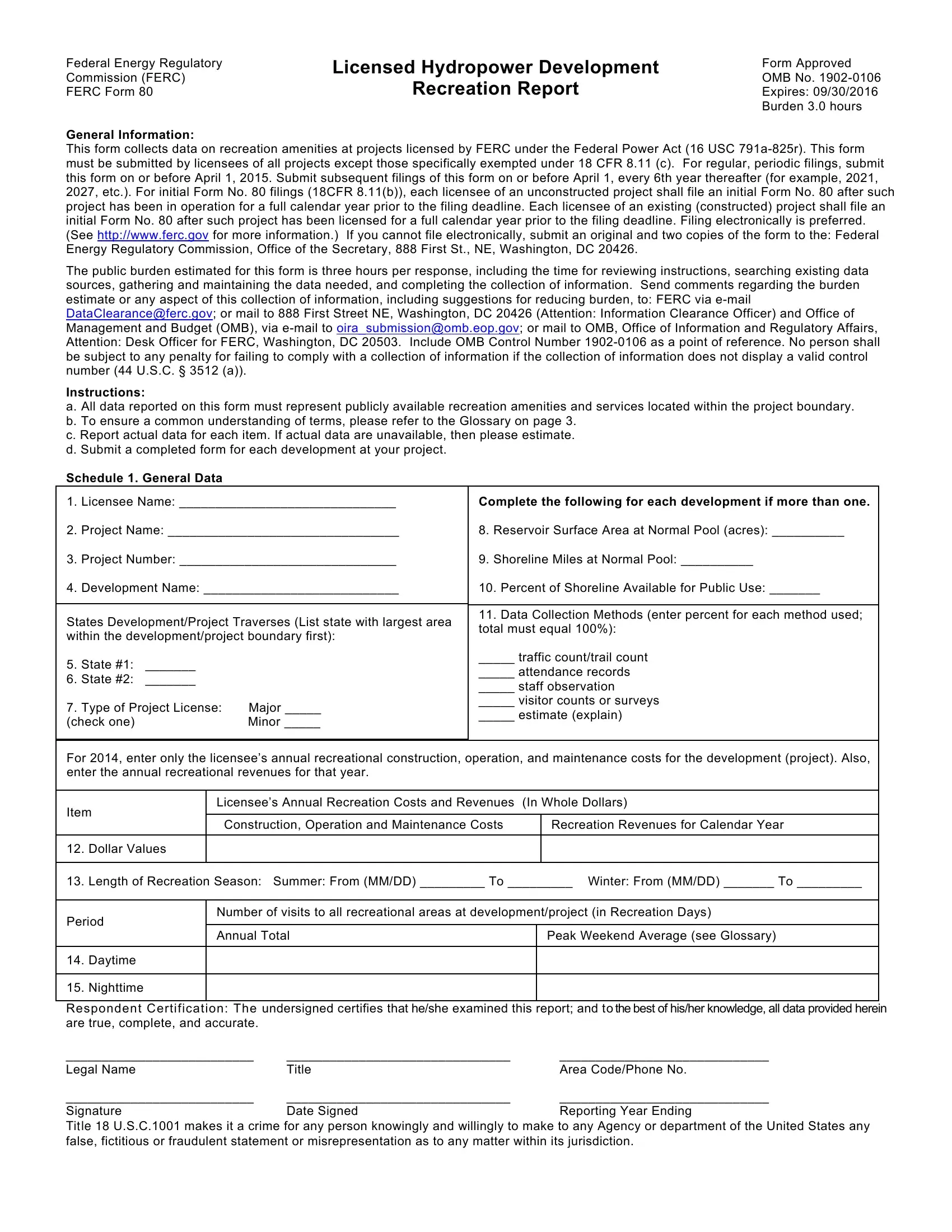
Federal Energy Regulatory
Commission (FERC)
FERC Form 80
Licensed Hydropower Development
Recreation Report
Form Approved OMB No.
General Information:
This form collects data on recreation amenities at projects licensed by FERC under the Federal Power Act (16 USC
The public burden estimated for this form is three hours per response, including the time for reviewing instructions, searching existing data sources, gathering and maintaining the data needed, and completing the collection of information. Send comments regarding the burden estimate or any aspect of this collection of information, including suggestions for reducing burden, to: FERC via
Instructions:
a. All data reported on this form must represent publicly available recreation amenities and services located within the project boundary. b. To ensure a common understanding of terms, please refer to the Glossary on page 3.
c. Report actual data for each item. If actual data are unavailable, then please estimate. d. Submit a completed form for each development at your project.
Schedule 1. General Data
1. |
Licensee Name: ______________________________ |
Complete the following for each development if more than one. |
|||
2. |
Project Name: ________________________________ |
8. Reservoir Surface Area at Normal Pool (acres): __________ |
|||
3. |
Project Number: ______________________________ |
9. Shoreline Miles at Normal Pool: __________ |
|||
4. |
Development Name: ___________________________ |
10. Percent of Shoreline Available for Public Use: _______ |
|||
|
|
|
|
|
|
States Development/Project Traverses (List state with largest area |
11. Data Collection Methods (enter percent for each method used; |
||||
total must equal 100%): |
|||||
within the development/project boundary first): |
|||||
|
|||||
5. |
State #1: |
_______ |
|
_____ traffic count/trail count |
|
|
_____ attendance records |
||||
6. |
State #2: |
_______ |
|
||
|
_____ staff observation |
||||
|
|
|
|
||
7. |
Type of Project License: |
Major _____ |
_____ visitor counts or surveys |
||
_____ estimate (explain) |
|||||
(check one) |
|
Minor _____ |
|||
|
|
||||
|
|
|
|
|
|
For 2014, enter only the licensee’s annual recreational construction, operation, and maintenance costs for the development (project). Also, enter the annual recreational revenues for that year.
Item |
Licensee’s Annual Recreation Costs and Revenues |
(In Whole Dollars) |
|||
|
|
|
|
||
|
|
Construction, Operation and Maintenance Costs |
|
|
Recreation Revenues for Calendar Year |
|
|
|
|
|
|
12. |
Dollar Values |
|
|
|
|
|
|
|
|
|
|
13. |
Length of Recreation Season: Summer: From (MM/DD) _________ To _________ Winter: From (MM/DD) _______ To _________ |
||||
|
|
|
|
||
Period |
Number of visits to all recreational areas at development/project (in Recreation Days) |
||||
|
|
|
|
||
|
|
Annual Total |
|
|
Peak Weekend Average (see Glossary) |
|
|
|
|
|
|
14. |
Daytime |
|
|
|
|
|
|
|
|
|
|
15. |
Nighttime |
|
|
|
|
|
|
|
|
|
|
Respondent Certification: The undersigned certifies that he/she examined this report; and to the best of his/her knowledge, all data provided herein are true, complete, and accurate.
__________________________ |
_______________________________ |
_____________________________ |
Legal Name |
Title |
Area Code/Phone No. |
__________________________ |
_______________________________ |
_____________________________ |
Signature |
Date Signed |
Reporting Year Ending |
TIT LE 18 U.S.C.1001 makes it a crime for any person knowingly and willingly to make to any Agency or department of the United States any false, fictitious or fraudulent statement or misrepresentation as to any matter within its jurisdiction.
Federal Energy Regulatory
Commission FERC
FERC Form 8
Licensed (ydropower Development Recreation Report
Page of
|
|
|
|
|
|
|
|
|
|
|
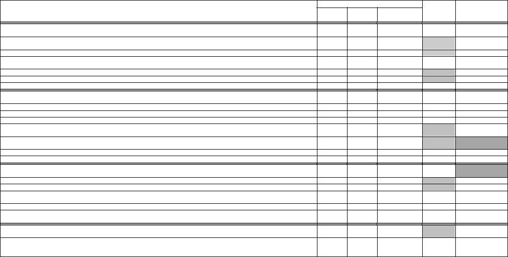
Schedule 2. Inventory of Publicly Available Recreation Amenities Within the Project Boundary |
|
||||||||||||
. Enter data for each Recreation Amenity Type a . For User Free b |
and User Fee c enter the number of publicly available recreation amenities, located within the project boundary, regardless of provider. For FERC |
|||||||||||||||||||||||
Approved |
d enter the number of amenities identified under User Free |
b and User Fee c for which the licensee has an ongoing responsibility for funding or maintenance see Glossary for further detail . For Capacity |
||||||||||||||||||||||
Utilization f , of the total publicly available amenities b + c , compare the average non‐peak weekend use see Glossary |
for each recreation amenity type during the recreation season, with the highest use, reported on |
|||||||||||||||||||||||
Schedule |
|
, )tem |
|
with the total combined capacity of each amenity type and enter a percentage that indicates their overall level of use. For example, if all public boat launches are used to half capacity during the non‐ |
||||||||||||||||||||
peak weekend days, enter % should use exceed capacity for an amenity type, enter the appropriate percentage above |
. |
Number of Recreation Amenities |
Total |
Capacity |
||||||||||||||||||||
|
|
|
|
|
|
|
|
|
|
|
|
|
|
|
|
|
|
|
||||||
|
|
|
|
|
|
|
|
|
|
|
|
|
|
|
|
Recreation Amenity Type (a) |
|
User |
User |
FERC |
Utilization (%) |
|||
|
|
|
|
|
|
|
|
|
|
|
|
|
|
|
|
|
|
|
||||||
Boat Launch Ar as. )mproved areas having one or more boat launch lanes enter number in column e and are usually marked with |
Free (b) |
Fee (c) |
Approved (d) |
Units (e) |
(f) |
|||||||||||||||||||
|
|
|
|
|
|
|
|
|
|
|
|
|
|
|
|
|
|
|
||||||
signs, have hardened surfaces, and typically have adjacent parking. |
|
|
Lanes |
|||||||||||||||||||||
|
|
|
|
|
|
|||||||||||||||||||
|
|
Facilities with more than |
slips on project waters, which include one or more of the following: docking, fueling, repair and |
|
|
|
|
|
|
|||||||||||||||
storage of boats; boat/equipment rental; or sell bait/food see Glossary FERC approved . |
|
|
|
|
|
|
|
|||||||||||||||||
Ma inas. |
|
|
|
|
|
|
|
|
|
|
Put‐ins/Take‐outs specifically designated for whitewater access. |
|
|
|
|
N/A |
|
|
||||||
Portag . |
Sites designed for launching and taking out canoes/kayaks and the improved, designated, and maintained trails connecting |
|
|
|
|
|
||||||||||||||||||
such sites |
|
|
|
|
N/A |
Feet |
|
|||||||||||||||||
|
enter length of trail in column e . |
|
|
|
|
|
|
|||||||||||||||||
Whitewater Boati . |
|
|
|
|
|
|
|
|
|
|
|
|
||||||||||||
Swim Areas. |
|
|
|
|
|
Platforms, walkways, or similar structures to facilitate below dam fishing. |
|
|
|
|
N/A |
|
|
|||||||||||
Tailwater Fishing. |
Platforms, walkways, or similar structures to facilitate fishing in the reservoir pool or feeder streams. |
|
|
|
|
Acres |
|
|||||||||||||||||
Trails. |
|
|
|
|
Sites providing swimming facilities bath houses, designated swim areas, parking and sanitation facilities . |
|
|
|
|
|
||||||||||||||
Reservoir Fishing. |
|
|
|
|
|
|
|
|
|
|
|
|
N/A |
|
|
|||||||||
|
Narrow tracks used for non‐automobile recreation travel which are mapped and designated for specific use s such as hiking, |
|
|
|
Miles |
|
||||||||||||||||||
biking, horseback riding, snowmobiling, or XC skiing excludes portages, paths or accessible routes; See Glossary . |
|
|
|
|
|
|||||||||||||||||||
Picnic Areas. |
|
|
|
|
|
|
|
|
Playground equipment, game courts/fields, golf/disc golf courses, jogging tracks, etc. |
|
|
|
|
Acres |
|
|||||||||
|
|
|
|
|
|
Locations containing one or more picnic sites each of which may include tables, grills, trash cans, and parking . |
|
|
|
Sites |
|
|||||||||||||
Active Recreation Ar as. |
|
|
|
|
|
|
|
|
Acres |
|
||||||||||||||
Visitor Centers. |
|
Sites established to view scenery, wildlife, cultural resources, project features, or landscapes. |
|
|
|
|
|
|||||||||||||||||
|
|
|
|
|
|
|
|
|
Buildings where the public can gather information about the development/project, its operation, nearby historic, |
|
|
|
|
|
|
|||||||||
natural, cultural, recreational resources, and other items of interest. |
|
|
|
|
|
|
|
|
||||||||||||||||
Overlooks/Vistas. |
|
|
|
Signage/Kiosks/Billboards which provide information about the development/project, its operation, nearby |
|
|
|
|
|
|
||||||||||||||
|
|
|
|
|
|
|
|
|
|
|
|
|
|
|
|
|
|
|
||||||
historic, natural, cultural, recreational resources, and other items of interest. |
|
|
|
|
Acres |
|
||||||||||||||||||
Winter Areas. |
|
Lands open to the general public for hunting. |
|
|
|
|
|
|
||||||||||||||||
Interpretive Displays. |
|
|
|
|
|
|
|
|
|
N/A |
|
N/A |
||||||||||||
C mpgrounds.Locations providing opportunities for skiing, sledding, curling, ice skating, or other winter activities. |
|
|
|
|
Acres |
|||||||||||||||||||
Hunting Areas. |
(ardened areas developed to cluster campers may include sites for tents, trailers, recreational vehicles [RV], yurts, |
|
|
|
N/A |
|
||||||||||||||||||
|
|
|
|
|
|
|
|
|
|
|
Acres |
N/A |
||||||||||||
cabins, or a combination, but excludes group camps . |
|
|
|
|
|
|||||||||||||||||||
|
|
|
|
Sites for tents, trailers, recreational vehicles [RV], yurts, cabins, or a combination of temporary uses. |
|
|
|
|
|
|
||||||||||||||
Campsites. |
|
|
Permanent, all‐weather, buildings rented for short‐term use, by the public, for recreational purposes. |
|
|
|
|
|
|
|||||||||||||||
|
|
|
|
|
|
|
Areas equipped to accommodate large groups of campers that are open to the general public may be operated by |
|
|
|
Sites |
|
||||||||||||
public, private, or non‐profit organizations . |
|
|
|
|
|
|
||||||||||||||||||
Cottage Sites. |
|
|
|
|
|
|
|
|
|
Places visitors are allowed to camp outside of a developed campground enter number of sites in clmn. e . |
|
|
|
N/A |
|
|
||||||||
Group Camps. |
|
|
|
|
|
|
|
|
|
|
|
|
|
|
|
N/A |
|
|
||||||
Inform l Use Areas. |
Well used locations which typically do not include amenities, but require operation and maintenance and/or |
|
|
|
Sites |
|
||||||||||||||||||
public safety responsibilities |
|
|
|
|
|
|
|
|
|
|||||||||||||||
Dispersed Cam |
|
ing Ar as. |
|
|
|
|
|
|
|
|
|
|
||||||||||||
Other. |
|
|
|
|
|
|
Well‐used sites not accounted for elsewhere on this form for visitors entering project lands or waters, without |
|
|
|
N/A |
|
|
|||||||||||
|
|
|
|
|
|
|
|
|
|
|
|
|
|
|
may have limited development such as parking, restrooms, signage . |
|
|
|
|
|
|
|||
trespassing, for recreational purposes |
|
|
|
|
|
|
|
|||||||||||||||||
|
Amenities that do not fit in the categories identified above. Please specify if more than one, separate by commas : |
|
|
|
|
|
|
|
||||||||||||||||
Access Points. |
|
|
|
|
|
|
|
|
|
|
|
|
|
|
|
|
|
|
||||||
Federal Energy Regulatory
Commission (FERC)
FERC Form 80
Licensed Hydropower Development
Recreation Report
Glossary of FERC Form 80 Terms
Page 3 of 3
Data Collection Methods. (Schedule 1, Item 11) – If a percentage is entered for the estimate alternative, please provide an explanation of the methods used (if submitted on a separate piece of paper, please include licensee name, project number, and development name)
Development. The portion of a project which includes:
(a)a reservoir; or
(b)a generating station and its
Exemption from Filing. Exemption from the filing of this form granted upon Commission approval of an application by a licensee pursuant to the provisions of 18 CFR 8.11(c).
General Public. Those persons who do not have special privileges to use the shoreline for recreational purposes, such as waterfront property ownership,
Licensee. Any person, state, or municipality licensed under the provisions of Section 4 of the Federal Power Act, and any assignee or successor in interest. For the purposes of this form, the terms licensee, owner, and respondent are interchangeable except where:
(a)the owner or licensee is a subsidiary of a parent company which has been or is required to file this form; or
(b)there is more than one owner or licensee, of whom only one is responsible for filing this form. Enter the name of the entity that is responsible for filing this report in Schedule 1, Item 2.1.
Major License. A license for a project of more than 1,500 kilowatts installed capacity.
Minor License. A license for a project of 1,500 kilowatts or less installed capacity.
Number of Recreation Amenities. Quantifies the availability of natural or
User Free (Schedule 2, column b) - Those amenities within the development/project that are free to the public;
User Fee (Schedule 2, column c) - Those amenities within the development/project where the licensee/facility operator charges a fee;
FERC Approved (Schedule 2, column d) – Those amenities within the development/project required by the Commission in a license or license amendment document, including an approved recreation plan or report. Recreation amenities that are within the project boundary, but were approved by the licensee through the standard land use article or by the Commission through an application for
Peak Use Weekend. Weekends when recreational use is at its peak for the season (typically Memorial Day, July 4th & Labor Day). On these weekends, recreational use may exceed the capacity of the area to handle such use. Include use for all three days in the holiday weekends when calculating Peak Weekend Average for items 14 & 15 on Schedule 1.
Recreation Day. Each visit by a person to a development (as defined above) for recreational purposes during any portion of a
Revenues. Income generated from recreation amenities at a given project/development during the previous calendar year. Includes fees for access or use of area.
Total Units (Schedule 2, column e) – Provide the total length, or area, or number that is appropriate for each amenity type using the metric provided.
Trails. Narrow tracks used for