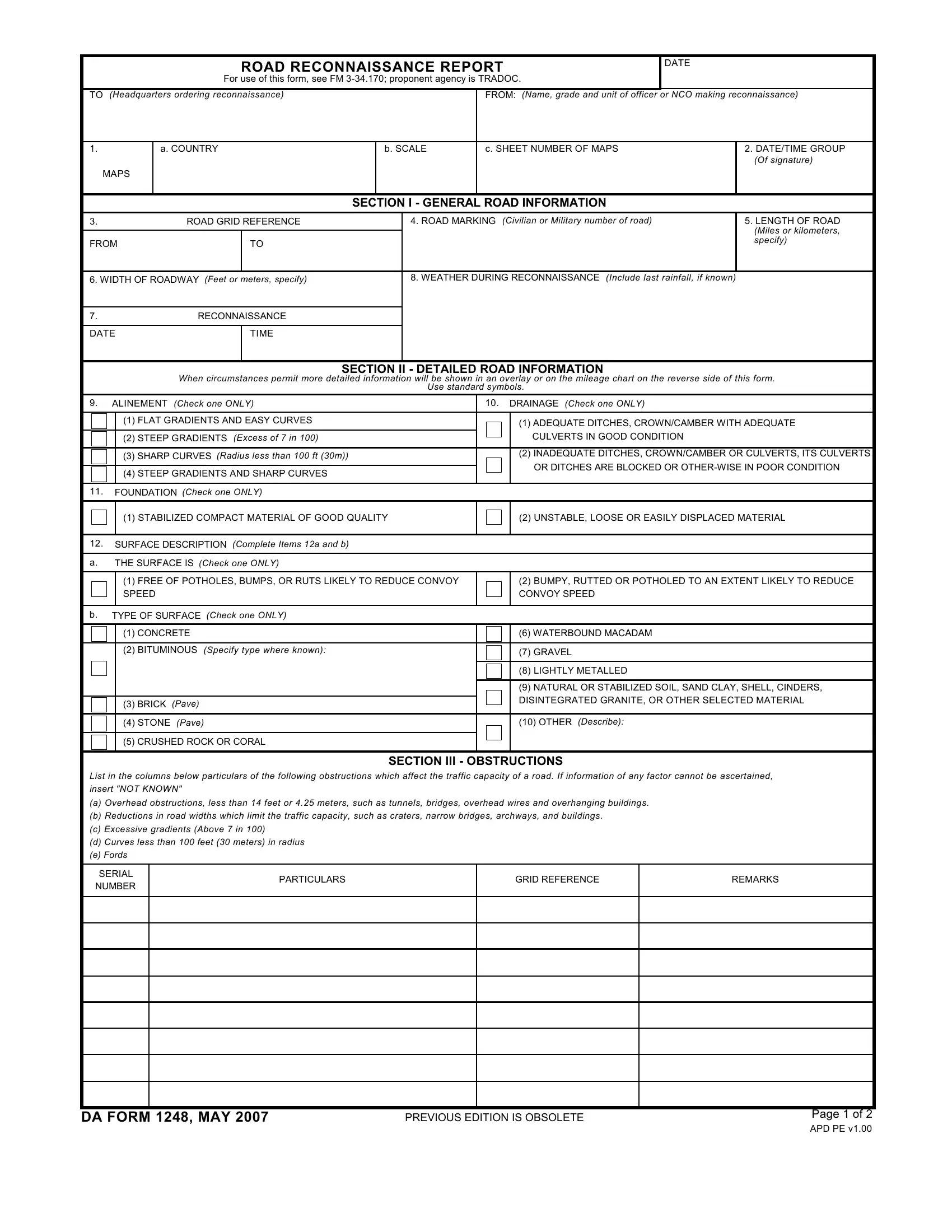
The DA Form 1248, also known as the Road Reconnaissance Report, is a comprehensive document used by the military to review and record the condition and details of roadways. This form plays a crucial role in the planning and execution of military operations, especially when it comes to understanding the logistical aspects of troop movements and the transportation of materials. It is structured to capture a wide range of information, from general road data including country, map references, and road markings, to more detailed assessments such as road width, length, surface conditions, and potential obstructions that could impede movement. Furthermore, the DA Form 1248 provides sections for recording weather conditions during reconnaissance, road alignment, drainage, and the foundation of the road, all of which could significantly impact military operations. This form, governed by the Training and Doctrine Command (TRADOC) and outlined in FM 3-34.170, is essential for military planners in assessing road capacities, determining logistic paths, and identifying any potential challenges that could arise due to the road conditions. By thoroughly completing this form, military units can ensure they are better prepared for navigating through varying terrains and optimizing their operational strategies.
| Question | Answer |
|---|---|
| Form Name | Da Form 1248 |
| Form Length | 2 pages |
| Fillable? | No |
| Fillable fields | 0 |
| Avg. time to fill out | 30 sec |
| Other names | da 1248 online, reconnaissance report online, reconnaissance report sample, da 1248 |
ROAD RECONNAISSANCE REPORT
For use of this form, see FM
DATE
TO (Headquarters ordering reconnaissance) |
|
|
|
FROM: (Name, grade and unit of officer or NCO making reconnaissance) |
|||
|
|
|
|
|
|
|
|
1. |
a. COUNTRY |
|
b. SCALE |
c. SHEET NUMBER OF MAPS |
2. DATE/TIME GROUP |
||
|
|
|
|
|
|
|
(Of signature) |
MAPS |
|
|
|
|
|
|
|
|
|
|
|
|
|
|
|
|
|
|
SECTION I - GENERAL ROAD INFORMATION |
|
|||
|
|
|
|
|
|
|
|
3. |
ROAD GRID REFERENCE |
|
|
4. ROAD MARKING (Civilian or Military number of road) |
5. LENGTH OF ROAD |
||
|
|
|
|
|
|
|
(Miles or kilometers, |
|
|
|
|
|
|
|
|
FROM |
|
TO |
|
|
|
|
specify) |
|
|
|
|
|
|
||
|
|
|
|
|
|
|
|
6. WIDTH OF ROADWAY (Feet or meters, specify) |
|
|
8. WEATHER DURING RECONNAISSANCE (Include last rainfall, if known) |
|
|||
7.RECONNAISSANCE
DATE |
TIME |
|
|
|
|
|
SECTION II - DETAILED ROAD INFORMATION |
|||
|
When circumstances permit more detailed information will be shown in an overlay or on the mileage chart on the reverse side of this form. |
|||
|
|
Use standard symbols. |
||
|
|
|
|
|
9. ALINEMENT (Check one ONLY) |
|
10. DRAINAGE (Check one ONLY) |
||
|
|
|
|
|
|
(1) FLAT GRADIENTS AND EASY CURVES |
|
|
(1) ADEQUATE DITCHES, CROWN/CAMBER WITH ADEQUATE |
|
|
|
|
|
|
(2) STEEP GRADIENTS (Excess of 7 in 100) |
|
|
CULVERTS IN GOOD CONDITION |
|
|
|
|
|
|
(3) SHARP CURVES (Radius less than 100 ft (30m)) |
|
|
(2) INADEQUATE DITCHES, CROWN/CAMBER OR CULVERTS, ITS CULVERTS |
|
|
|
|
|
|
|
|
|
OR DITCHES ARE BLOCKED OR |
|
(4) STEEP GRADIENTS AND SHARP CURVES |
|
||
|
|
|
|
|
|
|
|
|
|
11. FOUNDATION (Check one ONLY) |
|
|
|
|
|
|
|
|
|
|
(1) STABILIZED COMPACT MATERIAL OF GOOD QUALITY |
|
|
(2) UNSTABLE, LOOSE OR EASILY DISPLACED MATERIAL |
|
|
|
|
|
12.SURFACE DESCRIPTION (Complete Items 12a and b)
a. |
|
THE SURFACE IS (Check one ONLY) |
|
|
|
|
|
|
|
|
|
(1) FREE OF POTHOLES, BUMPS, OR RUTS LIKELY TO REDUCE CONVOY |
|
(2) BUMPY, RUTTED OR POTHOLED TO AN EXTENT LIKELY TO REDUCE |
|
|
SPEED |
|
CONVOY SPEED |
|
|
|
|
|
b. |
TYPE OF SURFACE (Check one ONLY) |
|
||
|
|
|
|
|
|
|
(1) CONCRETE |
|
(6) WATERBOUND MACADAM |
|
|
|
|
|
|
|
(2) BITUMINOUS (Specify type where known): |
|
(7) GRAVEL |
|
|
|
|
|
|
|
|
|
(8) LIGHTLY METALLED |
|
|
|
|
|
|
|
|
|
(9) NATURAL OR STABILIZED SOIL, SAND CLAY, SHELL, CINDERS, |
|
|
|
|
DISINTEGRATED GRANITE, OR OTHER SELECTED MATERIAL |
|
|
(3) BRICK (Pave) |
|
|
|
|
|
|
|
|
|
|
|
|
|
|
(4) STONE (Pave) |
|
(10) OTHER (Describe): |
|
|
|
|
|
|
|
(5) CRUSHED ROCK OR CORAL |
|
|
|
|
|
|
|
SECTION III - OBSTRUCTIONS
List in the columns below particulars of the following obstructions which affect the traffic capacity of a road. If information of any factor cannot be ascertained, insert "NOT KNOWN"
(a)Overhead obstructions, less than 14 feet or 4.25 meters, such as tunnels, bridges, overhead wires and overhanging buildings.
(b)Reductions in road widths which limit the traffic capacity, such as craters, narrow bridges, archways, and buildings.
(c)Excessive gradients (Above 7 in 100)
(d)Curves less than 100 feet (30 meters) in radius
(e)Fords
SERIAL NUMBER
PARTICULARS
GRID REFERENCE
REMARKS
DA FORM 1248, MAY 2007 |
PREVIOUS EDITION IS OBSOLETE |
Page 1 of 2 |
APD PE v1.00
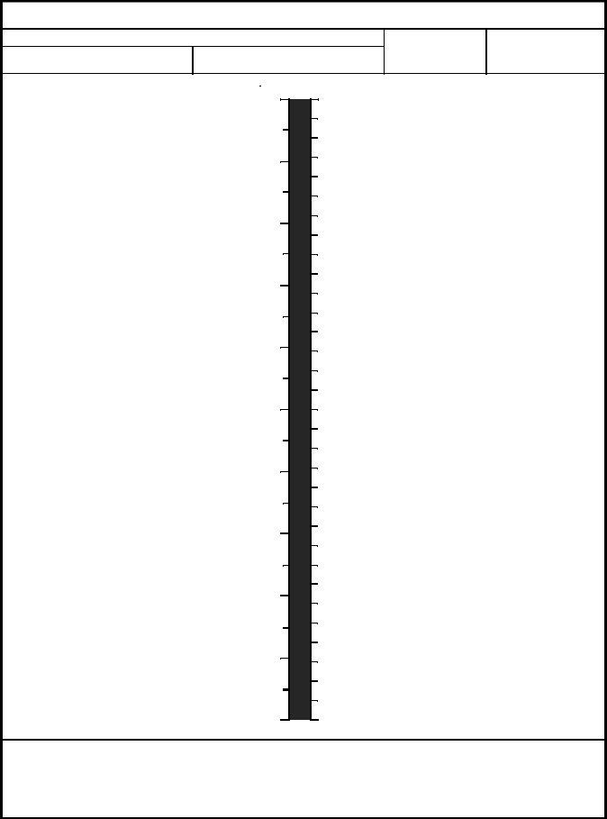
SECTION IV - MILEAGE CHART
ROUTE
FROM |
TO |
SCALE
DATE
ROAD INFORMATION |
|
|
DISTANCE |
|
ROAD INFORMATION |
|||
|
|
|
|
|
|
|
|
|
MILES |
10 |
|
|
|
|
KILOMETERS |
||
9
8
7
6
5
4
3
2
1
0
REMARKS
REVERSE OF DA FORM 1248, MAY 2007 |
Page 2 of 2 |
|
APD PE v1.00