Fema Form 086 0 33 PDF Details

Anyone who has worked with FEMA knows that they require a lot of paperwork. In order to apply for any type of assistance, you must fill out Form 086-0-33. This form is used to collect information about the nature and extent of your losses. Filling out this form correctly is critical, as it will help FEMA determine what type of assistance you qualify for. In this blog post, we will provide an overview of Form 086-0-33, so that you can make sure you are completing it correctly. We will also discuss some tips for making the application process easier.

QuestionAnswer
Form NameFema Form 086 0 33
Form Length15 pages
Fillable?No
Fillable fields0
Avg. time to fill out3 min 45 sec
Other namesA9, AO, Rico, C2

Form Preview Example

NATIONAL FLOOD INSURANCE PROGRAM

ElEvation CErtifiCatE

AND

INSTRUCTIONS

2012 EDITION

National Flood Insurance Program

ElEvAtion CErtiFiCAtE

Paperwork reduction Act notice

Public reporting burden for this data collection is estimated to average 3.75 hours per response. The burden estimate includes the time for reviewing instructions, searching existing data sources, gathering and maintaining the data needed, and completing and submitting this form. You are not required to respond to this collection of information unless a valid control number

is displaon this form. comments regarding the accurac of the burden estimate and ansuggestions for reducing the

burden to mation tment of , ederal

,

lington, PaperworPro

notE: Do not send your completed

form to this address.


Privacy Act Statement

Authority: Title

Principal Purpose(s): This information is being collected for the primarpurpose of estimating the rispremium rates necessarto provide lood insurance for new or substantiallved structures in designated

routine Use(s): The information on this form mabe disclosed as generallpermitted under 5 § 55of the Privacof as amended. This includes using this information as necessarand authoribthe routine uses published in

– Program iles or 73 ed. . 777

– Program of of 7ed. . 7

ebruar written consent, b or as required bw.

Disclosure: The disclosure of information on this form is voluntarhowever, failure to provide the information requested maresult in the inabilitto obtain lood insurance through the Program or the applicant mabe subto higher premium

rates for lood insurance. mation will onlmitted bw.

Purpose of the Elevation Certiicate

The vation tiicate is an important administrative tool of the Program is to be used to

provide elevation information necessarto ensure compliance with communitloodplain management ordinances, to determine the proper insurance premium rate, and to support a request for a of or of vision based on

ill

The vation tiicate is required in order to properlrate Postbuildings, which are buildings constructed after publication of the located in lood insurance

and . The vation tiicate is not required for Prebuildings unless the building is being rated under the optional Postules.

part of the agreement for malood insurance available in a communit, the requires the communitto adopt loodplain management regulations that specifminimum requirements for reducing lood losses. such requirement is for the communitto obtain the elevation of the lowest loor basementof all new and substantiallimproved buildings, and maintain a record of such information. The vation tiicate provides a wafor a communitto document compliance with the communits loodplain management ordinance.

of this certiicate does not provide a waiver of the lood insurance purchase requirement. a or from the ederal can amend the and remove the ederal mandate for a lending institution to require the

purchase of lood insurance. ever, the lending institution has the option of requiring lood insurance even if a has been issued bThe vation tiicate mabe used to support a or request. est loor and lowest ad

grade elevations certiied ba surveor engineer will be required if the certiicate is used to support a or request. leted whichever is appropriate.

This certiicate is used onlto certifbuilding elevations. separate certiicate is required for loodprooing. the, non residential buildings can be loodproofed up to or above the vation loodproofed building is a building that

has been designed and constructed to be watertight impermeable to loodwaters below the of

residential buildings is not permitted under the unless has granted the communitan exception for residential loodproofed basements. The communitmust adopt standards for design and construction of loodproofed basements before will grant a basement exception. or both loodproofed nonbuildings and residential loodproofed basements in communities that have been granted an exception b a loodprooing certiicate is required.

guidance can be found in Publication vation tiicate, available on ’s website at http.fema.govw

FEMA Form 086-0-33 (REVISED 7/12)

F-053

FEDERAL EMERGENCY MANAGEMENT AGENCY

ElEvAtion CErtiFiCAtE

U.S. DEPARTMENT OF HOMELAND SECURITY


National Flood Insurance Program

iMPortAnt: ollow the instructions on pages

o.

xpiration ateul, 5

SECtion A – ProPErtY inForMAtion

s

Polic

and...

Properts, Tax Parcel , etc.

., , etc.

tiicate is being used to obtain lood insurance.

or a building with a crawlspace or enclosure a wlspace or enclosure

bmanent lood openings in the crawlspace or enclosureve ad

c Total net area of lood openings in


d ngineered lood openings

Yes

.

sq ft

sq in

o

or a building with an attached garage


a

sq ft

bmanent lood openings in the attached garage within ve ad

c Total net area of lood openings in


sq in

d ngineered lood openings

Yes

o

SECtion B – FlooD inSUrAnCE rAtE MAP (FirM) inForMAtion

anelanel

vised

vation

, use base lood depth

vation

mined

vation datum used for rier

P

Yes

o

SECtion C – BUilDinG ElEvAtion inForMAtion (SUrvEY rEQUirED)

vations are based on

uction wings

uction

w vation tiicate will be required when construction of the building is complete.

vations –

.


h below according to the building diagram speciied in to , enter meters.


ertical

vation datum used for the elevations in items a.


vations must be the same as that used for the


a Top of bottom loor

crawlspace, or enclosure loor


.

b Top of the next higher loor


.


c


.

d


.

e


.

f


.

g


.

h


.

structural support


inished uction

feet

meters

feet

meters

feet

meters

feet

meters

feet

meters

feet

meters

feet

meters

feet

meters

SECtion D – SUrvEYor, EnGinEEr, or ArCHitECt CErtiFiCAtion

This certiication is to be signed and sealed bve, engineer, or architect authoriw to certifvation

information. I certify that the information on this Certificate represents my best efforts to interpret the data available. I understand that any false statement may be punishable by fine or imprisonment under 18 U.S. Code, Section 1001.

vided on bacm.

ere latitude and longitude in vided b


licensed land surve

Yes

o

tiier’s

P

Title

Telephone

orm

(REVISED 7/12)

verse side for continuation.

vious editions.

ElEvAtion CErtiFiCAtE, page 2

iMPortAnt: in these spaces, copy the corresponding information from Section A.


and...

Polic

SECtion D – SUrvEYor, EnGinEEr, or ArCHitECt CErtiFiCAtion (ContinUED)

vation tiicate for , and .

SECtion E – BUilDinG ElEvAtion inForMAtion (SUrvEY not rEQUirED) For ZonE Ao AnD ZonE A (WitHoUt BFE)

or complete tiicate is intended to support a complete or use natural grade, if available. to , enter meters.

Provide elevation information for the following and checvation is above or below the highest ad grade est ad

aop of bottom loor

crawlspace, or enclosure


.

bop of bottom loor

crawlspace, or enclosure


.

or manent lood openings provided in uctions

feet

meters

feet

meters

above or above or

below the below the

the next higher loor vation


.


feet

meters

Top of platform of machinervicing the building is


.


feet

meters


.


feet

meters

vailable, is the top of the bottom loor elevated in accordance with the communits loodplain management


ordinance

Yes

tifmation in


above or

above or

above or

below the

below the

below the

SECtion F – ProPErtY oWnEr (or oWnEr’S rEPrESEntAtivE) CErtiFiCAtion

The properts authori and and rect to the best of m

Properts s

Telephone

SECtion G – CoMMUnitY inForMAtion (oPtionAl)

The local oficial who is authoriw or ordinance to administer the communits loodplain management ordinance can complete and vation tiicate. . to , enter meters.

The information in ection as taen from other documentation that has be

en signed and sealed bicensed surveor, engineer, or architect

who is authoried baw to certiflevation information. ndicate th

e source and date of the elevation data in the omments area below.

.


The following information tems –s provided for communitl

oodplain management purposes.

Permit

ermit

tiicate

This permit has been issued for

vation of asest loor

s design lood elevation

w uction

vement

.


feet

meters

.


feet

meters

.


feet

meters

s

Title

Telephone

orm

(REVISED 7/12)

vious editions.

ElEvAtion CErtiFiCAtE, page 3

BUilDinG PHotoGrAPHS


uctions for

iMPortAnt: in these spaces, copy the corresponding information from Section A.

and...

Polic

using the vation tiicate to obtain lood insurance, afix at least building photographs below according to the instructions for all photographs with date taen“ront iew” and “ iew”and, if required, “ iew” and “

iew.” applicable, photographs must show the foundation with representative examples of the lood openings or vents, as indicated in it on this page, use the age.

orm

(REVISED 7/12)

vious editions.

ElEvAtion CErtiFiCAtE, page 4

BUilDinG PHotoGrAPHS


age

iMPortAnt: in these spaces, copy the corresponding information from Section A.

and...

Polic

submitting more photographs than will it on the preceding page, afix the additional photographs below. all photographs with date taen“ront iew” and “iew”and, if required, “iew” and “iew.” applicable, photographs must

show the foundation with representative examples of the lood openings or vents, as indicated in

orm

(REVISED 7/12)

vious editions.

U.S. DEPARTMENT OF HOMELAND SECURITY FEDERAL EMERGENCY MANAGEMENT AGENCY

National Flood Insurance Program

instructions for Completing

the Elevation Certificate

o.

xpiration ateul, 5

The Elevation Certificate is to be completed by a land surveyor, engineer, or architect who is authorized by law to certify elevation information when elevation information is required for Zones A1–A30, AE, AH, A (with BFE), VE, V1–V30, V (with BFE), AR, AR/A, AR/AE, AR/A1–A30, AR/AH, or AR/AO. Community officials who are authorized by law or ordinance to provide floodplain management information may also complete this form. For Zones AO and A (without BFE), a community official, a property owner, or an owner’s representative may provide information on this certificate, unless the elevations are intended for use in supporting a request for a LOMA or LOMR-F. Certified elevations must be included if the purpose of completing the Elevation Certificate is to obtain a LOMA or LOMR-F.

The property owner, the owner’s representative, or local official who is authorized by law to administer the community floodplain ordinance can complete Section A and Section B. The partially completed form can then be given to the land surveyor, engineer, or architect to complete Section C. The land surveyor, engineer, or architect should verify the information provided by the property owner or owner’s representative to ensure that this certificate is complete.

In Puerto Rico only, elevations for building information and flood hazard information may be entered in meters.

SECtion A – ProPErtY inForMAtion

items a1–a4. This section identifies the building, its location, and its owner. Enter the name(s) of the building owner(s), the building’s complete street address, and the lot and block numbers. If the building’s address is different from the owner’s address, enter the address of the building being certified. If the address is a rural route or a Post Office box number, enter the lot and block numbers, the tax parcel number, the legal description, or an abbreviated location description based on distance and direction from a fixed point of reference. For the purposes of this certificate, “building” means both a building and a manufactured (mobile) home.

A map may be attached to this certificate to show the location of the building on the property. A tax map, FIRM, or detailed community map is appropriate. If no map is available, provide a sketch of the property location, and the location of the building on the property. Include appropriate landmarks such as nearby roads, intersections, and bodies of water. For building use, indicate whether the building is residential, non-residential, an addition to an existing residential or non-residential building, an accessory building (e.g., garage), or other type of structure. Use the Comments area of the appropriate section if needed, or attach additional comments.

item a5. Provide latitude and longitude coordinates for the center of the front of the building. Use either decimal degrees (e.g., 39.5043°, -110.7585°) or degrees, minutes, seconds (e.g., 39° 30' 15.5", -110° 45' 30.7") format. If decimal degrees are used, provide coordinates to at least 4 decimal places or better. When using degrees, minutes, seconds, provide seconds to at least 1 decimal place or better. The latitude and longitude coordinates must be accurate within 66 feet. When the latitude and longitude are provided by a surveyor, check the “Yes” box in Section D and indicate the method used to determine the latitude and longitude in the Comments area of Section D. If the Elevation Certificate is being certified by other than a licensed surveyor, engineer, or architect, this information is not required. Provide the type of datum used to obtain the latitude and longitude. FEMA prefers the use of NAD 1983.

item a6. If the Elevation Certificate is being used to obtain flood insurance through the NFIP, the certifier must provide at least 2 photographs showing the front and rear of the building taken within 90 days from the date of certification. The photographs must be taken with views confirming the building description and diagram number provided in Section A. To the extent possible, these photographs should show the entire building including foundation. If the building has split-level or multi-level areas, provide at least 2 additional photographs showing side views of the building. In addition, when applicable, provide a photograph of the foundation showing a representative example of the flood openings or vents. All photographs must be in color and measure at least 3" × 3". Digital photographs are acceptable.

item a7. Select the diagram on pages 7–9 that best represents the building. Then enter the diagram number and use the diagram to identify and determine the appropriate elevations requested in Items C2.a–h. If you are unsure of the correct diagram, select the diagram that most closely resembles the building being certified.

item a8.a Provide the square footage of the crawlspace or enclosure(s) below the lowest elevated floor of an elevated building with or without permanent flood openings. Take the measurement from the outside of the crawlspace or enclosure(s). Examples of elevated buildings constructed with crawlspace and enclosure(s) are shown in Diagrams 6–9 on pages 8–9. Diagram 2, 4, or 9 should be used for a building constructed with a crawlspace floor that is below the exterior grade on all sides.

P levation ertificate nstructions – Page

items a8.b–d Enter in Item A8.b the number of permanent flood openings in the crawlspace or enclosure(s) that are no higher than 1.0 foot above the higher of the exterior or interior grade or floor immediately below the opening. (A permanent flood opening is a flood vent or other opening that allows the free passage of water automatically in both directions without human intervention.) If the interior grade elevation is used, note this in the Comments area of Section D. Estimate the total net area of all such permanent flood openings in square inches, excluding any bars, louvers, or other covers of the permanent flood openings, and enter the total in Item A8.c. If the net area cannot be reasonably estimated, provide the size of the flood openings without consideration of any covers and indicate in the Comments area the type of cover that exists in the flood openings. Indicate in Item A8.d whether the flood openings are engineered. If applicable, attach a copy of the Individual Engineered Flood Openings Certification or an Evaluation Report issued by the International Code Council Evaluation Service (ICC ES), if you have it. If the crawlspace or enclosure(s) have no permanent flood openings, or if the openings are not within 1.0 foot above adjacent grade, enter “0” (zero) in Items A8.b–c.

item a9.a Provide the square footage of the attached garage with or without permanent flood openings. Take the measurement from the outside of the garage.

items a9.b–d Enter in Item A9.b the number of permanent flood openings in the attached garage that are no higher than 1.0 foot above the higher of the exterior or interior grade or floor immediately below the opening. (A permanent flood opening is a flood vent or other opening that allows the free passage of water automatically in both directions without human intervention.) If the interior grade elevation is used, note this in the Comments area of Section D. This includes any openings that are in the garage door that are no higher than 1.0 foot above the adjacent grade. Estimate the total net area of all such permanent flood openings in square inches and enter the total in Item A9.c. If the net area cannot be reasonably estimated, provide the size of the flood openings without consideration of any covers and indicate in the Comments area the type of cover that exists in the flood openings. Indicate in Item A9.d whether the flood openings are engineered. If applicable, attach a copy of the Individual Engineered Flood Openings Certification or an Evaluation Report issued by the International Code Council Evaluation Service (ICC ES), if you have it. If the garage has no permanent flood openings, or if the openings are not within 1.0 foot above adjacent grade, enter “0” (zero) in Items A9.b–c.

SECtion B – FlooD inSUrAnCE rAtE MAP (FirM) inForMAtion

Complete the Elevation Certificate on the basis of the FIRM in effect at the time of the certification.

The information for Section B is obtained by reviewing the FIRM panel that includes the building’s location. Information about the current FIRM is available from the Federal Emergency Management Agency (FEMA) by calling 1-800-358-9616. If a Letter of Map Amendment (LOMA) or Letter of Map Revision (LOMR-F) has been issued by FEMA, please provide the letter date and case number in the Comments area of Section D or Section G, as appropriate.

For a building in an area that has been annexed by one community but is shown on another community’s FIRM, enter the community name and 6-digit number of the annexing community in Item B1, the name of the county or new county, if necessary, in Item B2, and the FIRM index date for the annexing community in Item B6. Enter information from the actual FIRM panel that shows the building location, even if it is the FIRM for the previous jurisdiction, in Items B4, B5, B7, B8, and B9.

If the map in effect at the time of the building’s construction was other than the current FIRM, and you have the past map information pertaining to the building, provide the information in the Comments area of Section D.

item B1. NFIP Community Name & Community Number. Enter the complete name of the community in which the building is located and the associated 6-digit community number. For a newly incorporated community, use the name and 6-digit number of the new community. Under the NFIP, a “community” is any State or area or political subdivision thereof, or any Indian tribe or authorized native organization, that has authority to adopt and enforce floodplain management regulations for the areas within its jurisdiction. To determine the current community number, see the NFIP Community Status Book, available on FEMA’s web site at http://www.fema.gov/fema/csb.shtm, or call 1-800-358-9616.

item B2. County Name. Enter the name of the county or counties in which the community is located. For an unincorporated area of a county, enter “unincorporated area.” For an independent city, enter “independent city.”

item B3. State. Enter the 2-letter state abbreviation (for example, VA, TX, CA).

items B4–B5. Map/Panel Number and Suffix. Enter the 10-character “Map Number” or “Community Panel Number” shown on the FIRM where the building or manufactured (mobile) home is located. For maps in a county-wide format, the sixth character of the “Map Number” is the letter “C” followed by a 4-digit map number. For maps not in a county-wide format, enter the “Community Panel Number” shown on the FIRM.

P levation ertificate nstructions – Page

item B6. FIRM Index Date. Enter the effective date or the map revised date shown on the FIRM Index.

item B7. FIRM Panel Effective/Revised Date. Enter the map effective date or the map revised date shown on the FIRM panel. This will be the latest of all dates shown on the map. The current FIRM panel effective date can be determined by calling 1-800-358-9616.

item B8. Flood Zone(s). Enter the flood zone, or flood zones, in which the building is located. All flood zones containing the letter “A” or “V” are considered Special Flood Hazard Areas. The flood zones are A, AE, A1–A30, V, VE, V1–V30, AH, AO, AR, AR/A, AR/AE, AR/A1–A30, AR/AH, and AR/AO. Each flood zone is defined in the legend of the FIRM panel on which it appears.

item B9. Base Flood Elevation(s). Using the appropriate Flood Insurance Study (FIS) Profile, Floodway Data Table, or FIRM panel, locate the property and enter the BFE (or base flood depth) of the building site. If the building is located in more than 1 flood zone in Item B8, list all appropriate BFEs in Item B9. BFEs are shown on a FIRM or FIS Profile for Zones A1–A30, AE, AH, V1–V30, VE, AR, AR/A, AR/AE, AR/A1–A30, AR/AH, and AR/AO; flood depth numbers are shown for Zone AO. Use the AR BFE if the building is located in any of Zones AR/A, AR/AE, AR/A1 A30, AR/AH, or AR/AO. In A or V zones where BFEs are not provided on the FIRM, BFEs may be available from another source. For example, the community may have established BFEs or obtained BFE data from other sources for the building site. For subdivisions and other developments of more than 50 lots or 5 acres, establishment of BFEs is required by the community’s floodplain management ordinance. If a BFE is obtained from another source, enter the BFE in Item B9. In an A Zone where BFEs are not available, complete Section E and enter N/A for Section B, Item B9. Enter the BFE to the nearest tenth of a foot (nearest tenth of a meter, in Puerto Rico).

item B10. Indicate the source of the BFE that you entered in Item B9. If the BFE is from a source other than FIS Profile, FIRM, or community, describe the source of the BFE.

item B11. Indicate the elevation datum to which the elevations on the applicable FIRM are referenced as shown on the map legend. The vertical datum is shown in the Map Legend and/or the Notes to Users on the FIRM.

item B12. Indicate whether the building is located in a Coastal Barrier Resources System (CBRS) area or Otherwise Protected Area (OPA). (OPAs are portions of coastal barriers that are owned by Federal, State, or local governments or by certain non- profit organizations and used primarily for natural resources protection.) Federal flood insurance is prohibited in designated CBRS areas or OPAs for buildings or manufactured (mobile) homes built or substantially improved after the date of the CBRS or OPA designation. For the first CBRS designations, that date is October 1, 1983. Information about CBRS areas and OPAs may be obtained on the FEMA web site at http://www.fema.gov/business/nfip/cbrs/cbrs.shtm.

SECtion C – BUilDinG ElEvAtion inForMAtion (SUrvEY rEQUirED)

Complete Section C if the building is located in any of Zones A1–A30, AE, AH, A (with BFE), VE, V1–V30, V (with BFE), AR, AR/A, AR/AE, AR/A1–A30, AR/AH, or AR/AO, or if this certificate is being used to support a request for a LOMA or LOMR-F. If the building is located in Zone AO or Zone A (without BFE), complete Section E instead. To ensure that all required elevations are obtained, it may be necessary to enter the building (for instance, if the building has a basement or sunken living room, split-level construction, or machinery and equipment).

Surveyors may not be able to gain access to some crawlspaces to shoot the elevation of the crawlspace floor. If access to the crawlspace is limited or cannot be gained, follow one of these procedures.

Use a yardstick or tape measure to measure the height from the floor of the crawlspace to the “next higher floor,” and then subtract the crawlspace height from the elevation of the “next higher floor.” If there is no access to the crawlspace, use the exterior grade next to the structure to measure the height of the crawlspace to the “next higher floor.”

Contact the local floodplain administrator of the community in which the building is located. The community may have documentation of the elevation of the crawlspace floor as part of the permit issued for the building.

If the property owner has documentation or knows the height of the crawlspace floor to the next higher floor, try to verify this by looking inside the crawlspace through any openings or vents.

In all 3 cases, provide the elevation in the Comments area of Section D on the back of the form and a brief description of how the elevation was obtained.

P levation ertificate nstructions – Page 3

item C1. Indicate whether the elevations to be entered in this section are based on construction drawings, a building under construction, or finished construction. For either of the first 2 choices, a post-construction Elevation Certificate will be required when construction is complete. If the building is under construction, include only those elevations that can be surveyed in Items C2.a–h. Use the Comments area of Section D to provide elevations obtained from the construction plans or drawings. Select “Finished Construction” only when all machinery and/or equipment such as furnaces, hot water heaters, heat pumps, air conditioners, and elevators and their associated equipment have been installed and the grading around the building is completed.

item C2. A field survey is required for Items C2.a–h. Most control networks will assign a unique identifier for each benchmark. For example, the National Geodetic Survey uses the Permanent Identifier (PID). For the benchmark utilized, provide the PID or other unique identifier assigned by the maintainer of the benchmark. For GPS survey, indicate the benchmark used for the base station, the Continuously Operating Reference Stations (CORS) sites used for an On-line Positioning User Service (OPUS) solution (also attach the OPUS report), or the name of the Real Time Network used.

Also provide the vertical datum for the benchmark elevation. All elevations for the certificate, including the elevations for Items C2.a–h, must use the same datum on which the BFE is based. Show the conversion from the field survey datum used if it differs from the datum used for the BFE entered in Item B9 and indicate the conversion software used. Show the datum conversion, if applicable, in the Comments area of Section D.

For property experiencing ground subsidence, the most recent reference mark elevations must be used for determining building elevations. However, when subsidence is involved, the BFE should not be adjusted. Enter elevations in Items C2.a–h to the nearest tenth of a foot (nearest tenth of a meter, in Puerto Rico).

items C2.a–d Enter the building elevations (excluding the attached garage) indicated by the selected building diagram (Item A7) in Items C2.a–c. If there is an attached garage, enter the elevation for top of attached garage slab in Item C2.d. (Because elevation for top of attached garage slab is self-explanatory, attached garages are not illustrated in the diagrams.) If the building is located in a V zone on the FIRM, complete Item C2.c. If the flood zone cannot be determined, enter elevations for all of Items C2.a–h. For buildings in A zones, elevations a, b, d, and e should be measured at the top of the floor. For buildings in V zones, elevation c must be measured at the bottom of the lowest horizontal structural member of the floor (see drawing below). For buildings


BUILDING ON


SLAB


A ZONES

V ZONES

C2.A


BASE FLOOD

ELEVATIONC2.C

ADJACENT

GRADE

BUILDING WITH

BUILDING ON PILES,

BASEMENT

PIERS, OR COLUMNS

C2.A A ZONES

V ZONES

A ZONES


C2.A


C2.C

BASE FLOOD


ELEVATION


elevated on a crawlspace, Diagrams 8 and 9, enter the elevation of the top of the crawlspace floor in Item C2.a, whether or not the crawlspace has permanent flood openings (flood vents). If any item does not apply to the building, enter “N/A” for not applicable.

item C2.e Enter the lowest platform elevation of at least 1 of the following machinery and equipment items: elevators and their associated equipment, furnaces, hot water heaters, heat pumps, and air conditioners in an attached garage or enclosure or on an open utility platform that provides utility services for the building. Note that elevations for these specific machinery and equipment items are required in order to rate the building for flood insurance. Local floodplain management officials are required to ensure that all machinery and equipment servicing the building are protected from flooding. Thus, local officials may require that elevation information for all machinery and equipment, including ductwork, be documented on the Elevation Certificate. If the machinery and/or equipment is mounted to a wall, pile, etc., enter the platform elevation of the machinery and/

P levation ertificate nstructions – Page

or equipment. Indicate machinery/equipment type and its general location, e.g., on floor inside garage or on platform affixed to exterior wall, in the Comments area of Section D or Section G, as appropriate. If this item does not apply to the building, enter “N/A” for not applicable.

items C2.f–g Enter the elevation of the ground, sidewalk, or patio slab immediately next to the building. For Zone AO, use the natural grade elevation, if available. This measurement must be to the nearest tenth of a foot (nearest tenth of a meter, in Puerto Rico) if this certificate is being used to support a request for a LOMA or LOMR-F.

item C2.h Enter the lowest grade elevation at the deck support or stairs. For Zone AO, use the natural grade elevation, if available. This measurement must be to the nearest tenth of a foot (nearest tenth of a meter, in Puerto Rico) if this certificate is being used to support a request for a LOMA or LOMR-F.

SECtion D – SUrvEYor, EnGinEEr, or ArCHitECt CErtiFiCAtion

Complete as indicated. This section of the Elevation Certificate may be signed by only a land surveyor, engineer, or architect who is authorized by law to certify elevation information. Place your license number, your seal (as allowed by the State licensing board), your signature, and the date in the box in Section D. You are certifying that the information on this certificate represents your best efforts to interpret the data available and that you understand that any false statement may be punishable by fine or imprisonment under 18 U.S. Code, Section 1001. Use the Comments area of Section D, on the back of the certificate, to provide datum, elevation, openings, or other relevant information not specified on the front.

SECtion E – BUilDinG ElEvAtion inForMAtion (SUrvEY not rEQUirED)

For ZonE Ao AnD ZonE A (WitHoUt BFE)

Complete Section E if the building is located in Zone AO or Zone A (without BFE). Otherwise, complete Section C instead. Explain in the Section F Comments area if the measurement provided under Items E1–E4 is based on the “natural grade.”

items E1.a and b Enter in Item E1.a the height to the nearest tenth of a foot (tenth of a meter in Puerto Rico) of the top of the bottom floor (as indicated in the applicable diagram) above or below the highest adjacent grade (HAG). Enter in Item E1.b the height to the nearest tenth of a foot (tenth of a meter in Puerto Rico) of the top of the bottom floor (as indicated in the applicable diagram) above or below the lowest adjacent grade (LAG). For buildings in Zone AO, the community’s floodplain management ordinance requires the lowest floor of the building be elevated above the highest adjacent grade at least as high as the depth number on the FIRM. Buildings in Zone A (without BFE) may qualify for a lower insurance rate if an engineered BFE is developed at the site.

item E2. For Building Diagrams 6–9 with permanent flood openings (see pages 8–9), enter the height to the nearest tenth of a foot (tenth of a meter in Puerto Rico) of the next higher floor or elevated floor (as indicated in the applicable diagram) above or below the highest adjacent grade (HAG).

item E3. Enter the height to the nearest tenth of a foot (tenth of a meter in Puerto Rico), in relation to the highest adjacent grade next to the building, for the top of attached garage slab. (Because elevation for top of attached garage slab is self-explanatory, attached garages are not illustrated in the diagrams.) If this item does not apply to the building, enter “N/A” for not applicable.

item E4. Enter the height to the nearest tenth of a foot (tenth of a meter in Puerto Rico), in relation to the highest adjacent grade next to the building, of the platform elevation that supports the machinery and/or equipment servicing the building. Indicate machinery/equipment type in the Comments area of Section F. If this item does not apply to the building, enter “N/A” for not applicable.

item E5. For those communities where this base flood depth is not available, the community will need to determine whether the top of the bottom floor is elevated in accordance with the community’s floodplain management ordinance.

SECtion F – ProPErtY oWnEr (or oWnEr’S rEPrESEntAtivE) CErtiFiCAtion

Complete as indicated. This section is provided for certification of measurements taken by a property owner or property owner’s representative when responding to Sections A, B, and E. The address entered in this section must be the actual mailing address of the property owner or property owner’s representative who provided the information on the certificate.

P levation ertificate nstructions – Page 5

SECtion G – CoMMUnitY inForMAtion (oPtionAl)

Complete as indicated. The community official who is authorized by law or ordinance to administer the community’s floodplain management ordinance can complete Sections A, B, C (or E), and G of this Elevation Certificate. Section C may be filled in by the local official as provided in the instructions below for Item G1. If the authorized community official completes Sections C, E, or G, complete the appropriate item(s) and sign this section.

Check item G1 if Section C is completed with elevation data from other documentation, including elevations obtained from the Community Rating System Elevation Software, that has been signed and sealed by a licensed surveyor, engineer, or architect who is authorized by law to certify elevation information. Indicate the source of the elevation data and the date obtained in the Comments area of Section G. If you are both a community official and a licensed land surveyor, engineer, or architect authorized by law to certify elevation information, and you performed the actual survey for a building in Zones A1–A30, AE, AH, A (with BFE), VE, V1–V30, V (with BFE), AR, AR/A, AR/A1–A30, AR/AE, AR/AH, or AR/AO, you must also complete Section D.

Check item G2 if information is entered in Section E by the community for a building in Zone A (without a FEMA-issued or community-issued BFE) or Zone AO.

Check item G3 if the information in Items G4–G10 has been completed for community floodplain management purposes to document the as-built lowest floor elevation of the building. Section C of the Elevation Certificate records the elevation of various building components but does not determine the lowest floor of the building or whether the building, as constructed, complies with the community’s floodplain management ordinance. This must be done by the community. Items G4–G10 provide a way to document these determinations.

item G4. Permit Number. Enter the permit number or other identifier to key the Elevation Certificate to the permit issued for the building.

item G5. Date Permit Issued. Enter the date the permit was issued for the building.

item G6. Date Certificate of Compliance/Occupancy Issued. Enter the date that the Certificate of Compliance or Occupancy or similar written official documentation of as-built lowest floor elevation was issued by the community as evidence that all work authorized by the floodplain development permit has been completed in accordance with the community’s floodplain management laws or ordinances.

item G7. New Construction or Substantial Improvement. Check the applicable box. “Substantial Improvement” means any reconstruction, rehabilitation, addition, or other improvement of a building, the cost of which equals or exceeds 50 percent of the market value of the building before the start of construction of the improvement. The term includes buildings that have incurred substantial damage, regardless of the actual repair work performed.

item G8. As-built lowest floor elevation. Enter the elevation of the lowest floor (including basement) when the construction of the building is completed and a final inspection has been made to confirm that the building is built in accordance with the permit, the approved plans, and the community’s floodplain management laws or ordinances. Indicate the elevation datum used.

item G9. BFE. Using the appropriate FIRM panel, FIS Profile, or other data source, locate the property and enter the BFE (or base flood depth) of the building site. Indicate the elevation datum used.

item G10. Community’s design flood elevation. Enter the elevation (including freeboard above the BFE) to which the community requires the lowest floor to be elevated. Indicate the elevation datum used.

Enter your name, title, and telephone number, and the name of the community. Sign and enter the date in the appropriate blanks.

P levation ertificate nstructions – Page

Building Diagrams

The following diagrams illustrate various types of buildings. Compare the features of the building being certified with the features shown in the diagrams and select the diagram most applicable. Enter the diagram number in Item A7, the square footage of crawlspace or enclosure(s) and the area of flood openings in square inches in Items A8.a–c, the square footage of attached garage and the area of flood openings in square inches in Items A9.a–c, and the elevations in Items C2.a–h.

In A zones, the floor elevation is taken at the top finished surface of the floor indicated; in V zones, the floor elevation is taken at the bottom of the lowest horizontal structural member (see drawing in instructions for Section C).

DiAGrAM 1A

All slab-on-grade single- and multiple-loor buildings (other than split-level) and high-rise buildings, either detached or row type (e.g., townhouses); with or without attached garage.

Distinguishing Feature – The bottom floor is at or above ground level grade on at least side.

C2.b

C2.a

NEXT HIGHER

FLOOR


DiAGrAM 1B

All raised-slab-on-grade or slab-on-stem-wall-with-ill single- and multiple-loor buildings (other than split- level), either detached or row type (e.g., townhouses); with or without attached garage.

Distinguishing Feature – The bottom floor is at or above ground level grade on at least side.

C2.b

C2.a

NEXT HIGHER

FLOOR


GRADE

BOTTOM FLOOR

BOTTOM FLOOR

GRADE

C2.f–h

(determined by

existing grade)

(determined by C2.f–h existing grade)

DiAGrAM 2

All single- and multiple-loor buildings with basement (other than split-level) and high-rise buildings

with basement, either detached or row type (e.g., townhouses); with or without attached garage.

Distinguishing Feature – The bottom floor basement or underground garage is below ground level grade o n all sides.

C2.a

C2.b

NEXT HIGHER

FLOOR

GRADE

BOTTOM FLOOR

BASEMENT

C2.f–h

(determined by

existing grade)

*A floor that is below ground level (grade) on all sides is considered a basement even if the floor is used for living purposes, or as an office, garage, workshop, etc.

P levation ertificate nstructions – Page 7

DiAGrAM 3

All split-level buildings that are slab-on-grade, either detached or row type (e.g., townhouses); with or without attached garage.

Distinguishing Feature – The bottom floor excluding garage is at or above ground level grade on at least side.

C2.a

C2.b

HIGHER

FLOORS

NEXT HIGHER

GRADE BOTTOMFLOOR

FLOOR

(determined by C2.f–h existing grade)

DiAGrAM 5

All buildings elevated on piers, posts, piles, columns, or parallel shear walls. no obstructions below the elevated loor.

Distinguishing Feature – or all ones, the area below the elevated floor is open, with no obstruction to flow of floodwaters open lattice wor andor insect screening is permi ssible.

C2.b

NEXT HIGHER

FLOOR

C2.a

ELEVATED

FLOOR

GRADE

C2.f–h

(determined by


existing grade)

C2.c (For V zones only)

DiAGrAM 4

All split-level buildings (other than slab-on-grade), either detached or row type (e.g., townhouses); with or without attached garage.

Distinguishing Feature – The bottom floor basement or underground garage is below ground level grade o n all sides.

C2.a

C2.b


HIGHER


FLOORS


GRADE

NEXT HIGHER


BOTTOM FLOOR

FLOOR

(BASEMENT)


(determined by C2.f–h existing grade)

DiAGrAM 6

All buildings elevated on piers, posts, piles, columns, or parallel shear walls with full or partial enclosure below the elevated floor.

Distinguishing Feature – or all ones, the area below the elevated floor is enclosed, either partiall or ful l. n ones, the partiall or full enclosed area below the elev ated floor is with or without openings present in the walls of the enclosure. ndicate information about enclosure sie and openi ngs in ection

– Propert nformation.

NEXT HIGHER

C2.aFLOOR

C2.aFLOORC2.b

ELEVATED

ELEVATED

FLOOR

FLOOR

A8.a–c

GRADE

GRADE

ENCLOSURE Determine enclosure size &

openings, if any.

C2.f-h

(determined by

C2.c


C2.f–h

existing grade)

(For V zones only)


floor that is below ground level grade on al l sides is considered a basement even if the floor is used for living purposes, or as an office, garage, worshop, etc.

n “opening” is a permanent opening that allows

for the free passage of water automaticall in bot h directions without human intervention.

nder the P, a minimum of openings is required


for enclosures or crawlspaces. The openings shall provide a total net area of not less

than square inch for ever square foot of area en closed, excluding an bars, louvers, or other covers of the opening. lternativel, an

ndividual ngineered lood penings ertification


or an valuation eport issued b the nternational

ode ouncil valuation ervice

must be submitted to document that the design o

f the openings will allow for the automatic equali ation of hdrostatic flood forces on

exterior walls. window, a door, or a garage door is not considered an opening openings ma be instal led in doors. penings shall be on at least sides of the enclosed area. f a building h as more than enclosed area, each area must have o penings to allow floodwater to directl enter. The bottom of the openings must be no higher than foot above the higher of the exterior or i nterior grade or floor immediatel below

the opening. or more guidance on openings, see

P Technical ulletin

P levation ertificate nstructions – Page

DiAGrAM 7

All buildings elevated on full-story foundation walls with a partially or fully enclosed area below the elevated loor. this includes walkout levels, where at least 1 side is at or above grade. the principal use of this building is located in the elevated loors of the building.

Distinguishing Feature – or all ones, the area below the elevated floor is enclosed, either partiall or ful l. n ones, the

partiall or full enclosed area below the elevated floor is with or

without openings present in the walls of the encl

osure. ndicate

information about enclosure sie and openings in e

ction –

Propert nformation.


C2.a


C2.b

NEXT HIGHER


FLOOR


GRADE


C2.f

WALKOUT LEVEL

C2.g


(ENCLOSURE)


DiAGrAM 8

All buildings elevated on a crawlspace with the loor of the crawlspace at or above grade on at least 1 side, with or without an attached garage.

Distinguishing Feature – or all ones, the area below the first floor is enclosed b solid or partial perimeter wal ls. n all ones, the crawlspace is with or without openings presen t in the walls of the crawlspace. ndicate information about craw lspace sie and openings in ection – Propert nformation.

C2.a

C2.b

GRADE

NEXT HIGHER


FLOOR

C2.f

C2.g


CRAWLSPACE

A8.b–c

A8.a A8.b–c

A8.b–cA8.a

OPENINGS**OPENING**

OPENINGS**

DiAGrAM 9

All buildings (other than split-level) elevated on a sub-grade crawlspace, with or without attached garage.

Distinguishing Feature – The bottom crawlspace floor is below ground level grade on all sides. f the distanc e from the crawlspace floor to the top of the next higher floor is more than 5 feet, or the crawlspace floor is more than feet b elow the grade on all sides, use iagram .


C2.a

C2.b


NEXT HIGHER


GRADE

FLOOR


C2.g


C2.f


SUBGRADE CRAWLSPACE


A8.b-c

A8.a


OPENINGS*


floor that is below ground level grade on al

l sides is considered a basement even if the floor is used for living purposes, or as an office,

garage, worshop, etc.


n “opening” is a permanent opening that allows


for the free passage of water automaticall in bot h directions without human intervention.

nder the P, a minimum of openings is required

for enclosures or crawlspaces. The openings shall provide a total net area of not less

than square inch for ever square foot of area en

closed, excluding an bars, louvers, or other covers

of the opening. lternativel, an

ndividual ngineered lood penings ertification


or an valuation eport issued b the nternational

ode ouncil valuation ervice

must be submitted to document that the design o f the openings will allow for the automatic equali ation of hdrostatic flood forces on

exterior walls. window, a door, or a garage door

is not considered an opening openings ma be instal

led in doors. penings shall be on at

least sides of the enclosed area. f a building h

as more than enclosed area, each area must have o penings to allow floodwater to directl

enter. The bottom of the openings must be no higher than foot above the higher of the exterior or i

nterior grade or floor immediatel below

the opening. or more guidance on openings, see

P Technical ulletin


P levation ertificate nstructions – Page

How to Edit Fema Form 086 0 33 Online for Free

Working with PDF forms online is actually a piece of cake with this PDF editor. You can fill out AO here painlessly. To retain our editor on the cutting edge of convenience, we aim to put into action user-oriented features and improvements regularly. We are routinely looking for suggestions - assist us with remolding how you work with PDF forms. If you're seeking to begin, this is what it will require:

Step 1: Hit the "Get Form" button above on this page to open our PDF editor.

Step 2: After you access the online editor, you will notice the form prepared to be filled out. Other than filling in different blanks, you can also perform some other things with the Document, that is adding any words, modifying the initial text, adding illustrations or photos, placing your signature to the PDF, and much more.

In order to fill out this form, ensure you provide the required details in every blank:

1. While completing the AO, be certain to include all of the needed blanks within the associated form section. This will help to expedite the process, making it possible for your information to be processed swiftly and appropriately.

Part no. 1 of filling out A1A30

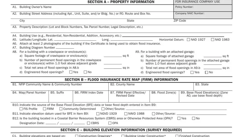
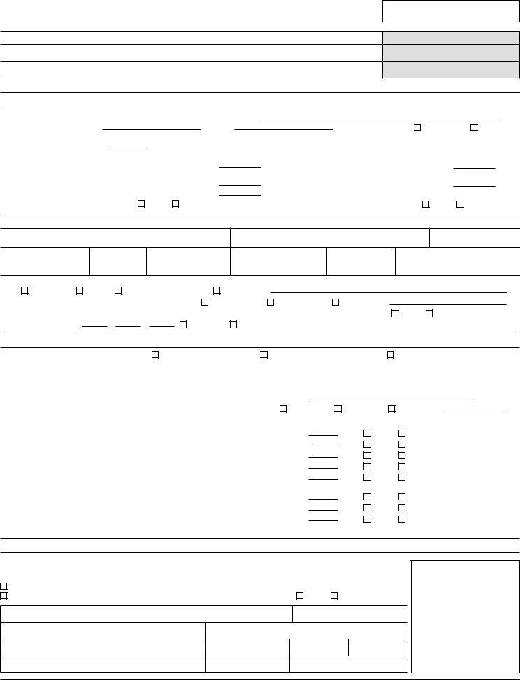
2. When the previous segment is complete, you're ready put in the required details in C Elevations Zones AA AE AH A, Cah below according to the, Benchmark Utilized, Vertical Datum, Indicate elevation datum used for, NGVD, NAVD, OtherSource, Check the measurement used, a Top of bottom loor including, b Top of the next higher loor, c Bottom of the lowest horizontal, d Attached garage top of slab, e Lowest elevation of machinery or, and Describe type of equipment and so that you can go further.

A1A30 conclusion process explained (portion 2)

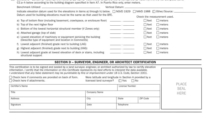
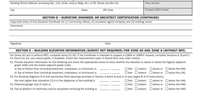
3. This 3rd step should also be rather easy, iMPortAnt in these spaces copy the, FOR INSURANCE COMPANY USE, Building Street Address including, Policy Number, City, State, ZIP Code, Company NAIC Number, Copy both sides of this Elevation, SECtion D SUrvEYor EnGinEEr or, Comments, Signature, Date, SECtion E BUilDinG ElEvAtion, and For Zones AO and A without BFE - these empty fields needs to be filled in here.

Writing segment 3 in A1A30

It's simple to get it wrong when filling in the State, thus make sure to go through it again prior to when you send it in.

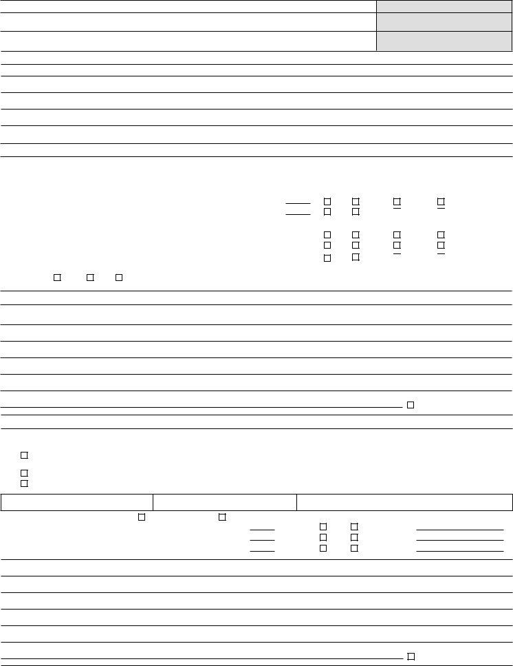
4. To go onward, your next step involves filling out a few fields. Examples of these are E Zone AO only If no lood depth, ordinance, Yes, Unknown The local oficial must, SECtion F ProPErtY oWnEr or, The property owner or owners, Property Owner or Owners, Address, Signature, Comments, City, Date, State, ZIP Code, and Telephone, which you'll find fundamental to moving forward with this particular process.

Step no. 4 in submitting A1A30

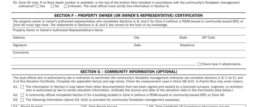
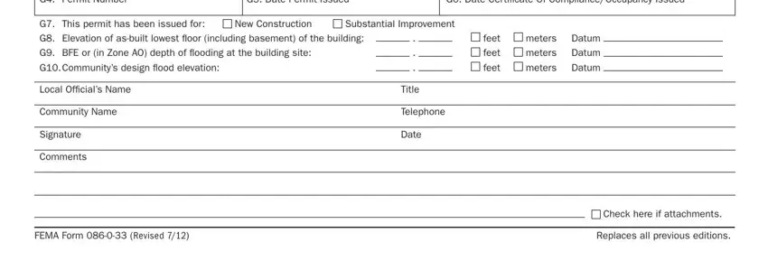
5. The pdf should be finalized by filling in this section. Further you have a comprehensive set of blank fields that must be completed with accurate details for your document submission to be accomplished: G Permit Number, G Date Permit Issued, G Date Certiicate Of, G This permit has been issued for, New Construction, G Elevation of asbuilt lowest loor, Substantial Improvement, G BFE or in Zone AO depth of, G Communitys design lood elevation, Local Oficials Name, Community Name, Signature, Comments, Title, and Telephone.

The best way to fill out A1A30 portion 5

Step 3: Prior to submitting your document, make sure that form fields were filled in correctly. When you’re satisfied with it, click “Done." Sign up with FormsPal now and instantly access AO, ready for downloading. Each edit you make is handily preserved , making it possible to edit the form further anytime. FormsPal guarantees your data privacy by using a secure method that never records or shares any private information typed in. You can relax knowing your paperwork are kept safe whenever you work with our tools!