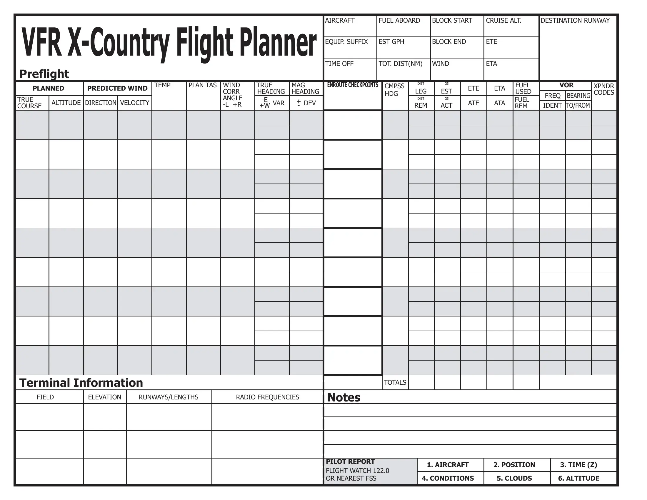
Embarking on a journey by air involves meticulous planning and preparation, not just for the pilot but for the entire aviation ecosystem involved in ensuring a safe and efficient flight. At the heart of this preparatory phase is the Flight Plan form, a crucial document that outlines every detail of the planned flight. This comprehensive form captures essential information such as the aircraft's fuel status, intended cruise altitude, destination, and the runway from which it will launch. It goes further to detail the voyage through sections such as the estimated gallons per hour (GPH) of fuel consumption, block times marking the start and end of the journey, total estimated time en route (ETE), and the time of takeoff. For those navigating beyond the immediate surroundings, the VFR (Visual Flight Rules) Cross-Country Flight Planner segment is indispensable, offering a means to plot the journey meticulously. Additionally, the form encompasses technical details like equipment suffix, TAS (True Air Speed), wind adjustments, and magnetic headings, essential for a precise navigation strategy. It also includes pre-flight and en-route checkpoints, compass headings, and VOR (VHF Omni-directional Range) details, enhancing the navigational accuracy. The planner even anticipates deviations caused by wind corrections and gives space for terminal information, ensuring the flight adheres to planned vs. predicted conditions thoroughly. By integrating sections for pilot reports and flight watch information, it ensures pilots can communicate vital information and stay informed about conditions as they evolve. This document is not just a formality but a blueprint for safety, efficiency, and regulatory compliance, weaving together myriad details into a coherent plan of action designed to guide flights from departure to arrival smoothly.
| Question | Answer |
|---|---|
| Form Name | Flight Plan Form |
| Form Length | 1 pages |
| Fillable? | No |
| Fillable fields | 0 |
| Avg. time to fill out | 15 sec |
| Other names | printable flight plan form, international flight plan, flight plan form, online editable flight plan |

|
|
|
|
|
|
|
|
|
|
AIRCRAFT |
|
FUEL ABOARD |
BLOCK START |
CRUISE ALT. |
DESTINATION RUNWAY |
|
||||||
|
|
|
|
|
|
|
|
|
|
|
|
|
||||||||||
|
EQUIP. SUFFIX |
|
EST GPH |
|
BLOCK END |
|
ETE |
|
|
|
|
|
||||||||||
|
|
|
|
|
|
|
|
|
|
TIME OFF |
|
TOT. DIST(NM) |
WIND |
|
ETA |
|
|
|
|
|
||
|
Preflight |
|
|
|
|
|
|
|
|
|
|
|
|
|
|
|
|
|
|
|
|
|
|
|
|
|
|
TEMP |
PLAN TAS |
WIND |
TRUE |
MAG |
ENROUTE CHECKPOINTS |
|
CMPSS |
DIST |
GS |
|
|
FUEL |
VOR |
XPNDR |
|
||
|
PLANNED |
PREDICTED WIND |
|
|
CORR |
HEADING |
HEADING |
|
|
|
HDG |
LEG |
EST |
ETE |
ETA |
USED |
|
|
CODES |
|
||
|
|
|
|
|
|
FREQ |
BEARING |
|
||||||||||||||
|
TRUE |
|
|
|
|
|
ANGLE |
+ DEV |
|
|
|
|
DIST |
GS |
|
|
FUEL |
|
|
|||
|
ALTITUDE |
DIRECTION |
VELOCITY |
|
|
|
|
|
|
REM |
ACT |
ATE |
ATA |
IDENT |
TO/FROM |
|
|
|||||
|
COURSE |
|
|
|
|
|
+W |
- |
|
|
|
|
|
|
REM |
|
|
|||||
|
|
|
|
|
|
|
|
|
|
|
|
|
|
|
|
|
|
|
|
|
|
|
|
|
|
|
|
|
|
|
|
|
|
|
|
|
|
|
|
|
|
|
|
|
|
|
|
|
|
|
|
|
|
|
|
|
|
|
|
|
|
|
|
|
|
|
|
|
|
|
|
|
|
|
|
|
|
|
|
|
|
|
|
|
|
|
|
|
|
|
|
|
|
|
|
|
|
|
|
|
|
|
|
|
|
|
|
|
|
|
|
|
|
|
|
|
|
|
|
|
|
|
|
|
|
|
|
|
|
|
|
|
|
|
|
|
|
|
|
|
|
|
|
|
|
|
|
|
|
|
|
|
|
|
|
|
|
|
|
|
|
|
|
|
|
|
|
|
|
|
|
|
|
|
|
|
|
|
|
|
|
|
|
|
|
|
|
|
|
|
|
|
|
|
|
|
|
|
|
|
|
|
|
|
|
|
|
|
|
|
|
|
|
|
|
|
|
|
|
|
|
|
|
|
|
|
|
|
|
|
|
|
|
|
|
|
|
|
|
|
|
|
|
|
|
|
|
|
|
|
|
|
|
|
|
|
|
|
|
|
|
|
|
|
|
|
|
|
|
|
|
|
|
|
|
|
|
|
|
|
|
|
|
|
|
|
|
|
|
|
|
|
|
|
|
|
|
|
|
|
|
|
|
|
|
|
|
|
|
|
|
|
|
|
|
|
|
|
|
|
|
|
|
|
|
|
|
|
|
|
|
|
|
|
|
|
|
|
|
|
|
|
|
|
|
|
|
|
|
|
|
|
|
|
|
|
|
|
|
|
|
|
|
|
|
|
|
|
|
|
|
|
|
|
|
|
|
|
|
|
|
|
|
|
|
|
|
|
|
|
|
|
|
|
|
|
|
|
|
|
|
|
|
|
|
|
|
|
|
|
|
|
|
Terminal Information |
|
TOTALS |
|
FIELD |
ELEVATION RUNWAYS/LENGTHS |
RADIO FREQUENCIES |
Notes |
PILOT REPORT
FLIGHT WATCH 122.0 OR NEAREST FSS
1. AIRCRAFT |
2. POSITION |
3. TIME (Z) |
|
|
|
4. CONDITIONS |
5. CLOUDS |
6. ALTITUDE |
|
|
|