Navigating the intricacies of the New Jersey Department of Environmental Protection's Water Allocation Permit Application Renewal process requires a thorough understanding of the BWA-001 B form, revised in November 2015. This comprehensive document plays a critical role for entities seeking to renew their water allocation permits, a crucial step in ensuring the responsible management and distribution of the state's water resources. The form requires detailed input covering a range of areas, including the location and specifics of the proposed diversion facility, property and landowner details, information about the applicant and operating entities, and a host of related aspects vital for a successful application. It also mandates disclosures about other relevant permits, a move designed to streamline the process and prevent unnecessary duplication of data within the Department's databases. Moreover, the form extends to certifications by the highest-ranking individuals within the applying entity, emphasizing the seriousness and legal obligations tied to the accuracy and completeness of the information provided. Lastly, it outlines the necessary submissions and attachments, including engineering plans and water conservation strategies, underscoring the comprehensive planning required to manage water resources effectively. Understanding the BWA-001 B form is crucial for any entity involved in water diversion and allocation within New Jersey, highlighting the state's commitment to preserving this vital resource through meticulous and regulated management.
| Question | Answer |
|---|---|
| Form Name | Form Bwa 001 B |
| Form Length | 12 pages |
| Fillable? | No |
| Fillable fields | 0 |
| Avg. time to fill out | 3 min |
| Other names | nj bwa application online, bwa b allocation get, nj bwa permit application, nj bwa application get |

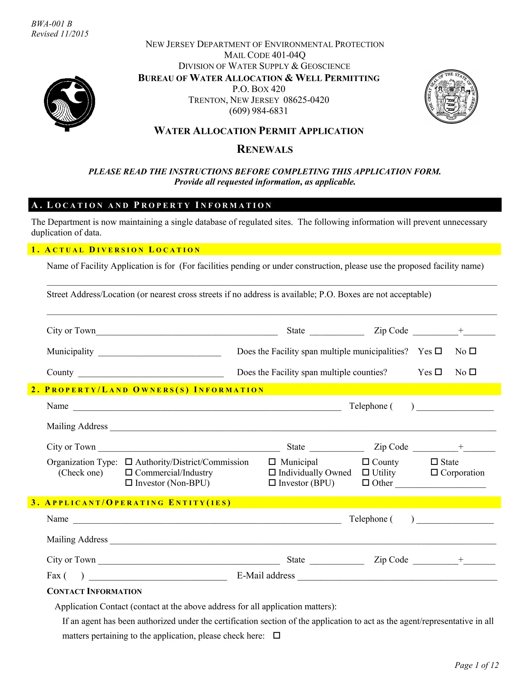
Revised 11/2015
NEW JERSEY DEPARTMENT OF ENVIRONMENTAL PROTECTION
MAIL CODE
DIVISION OF WATER SUPPLY & GEOSCIENCE
BUREAU OF WATER ALLOCATION & WELL PERMITTING
P.O. BOX 420
TRENTON, NEW JERSEY
(609)
WATER ALLOCATION PERMIT APPLICATION
RENEWALS
PLEASE READ THE INSTRUCTIONS BEFORE COMPLETING THIS APPLICATION FORM.
Provide all requested information, as applicable.
A . L O C A T I O N A N D P R O P E R T Y I N F O R M A T I O N
The Department is now maintaining a single database of regulated sites. The following information will prevent unnecessary duplication of data.
1 . A C T U A L D I V E R S I O N L O C A T I O N
Name of Facility Application is for (For facilities pending or under construction, please use the proposed facility name)
________________________________________________________________________________________________________
Street Address/Location (or nearest cross streets if no address is available; P.O. Boxes are not acceptable)
________________________________________________________________________________________________________
City or Town________________________________________ State ____________ Zip Code __________+_______
Municipality ___________________________ |
Does the Facility span multiple municipalities? |
Yes |
No |
County ________________________________ |
Does the Facility span multiple counties? |
Yes |
No |
|
|
|
|
2 . P R O P E R T Y / L A N D O W N E R S ( S ) I N F O R M A T I O N |
|
|
|
Name ___________________________________________________________ Telephone ( |
) _________________ |
||
Mailing Address _____________________________________________________________________________________
City or Town ________________________________________ State ____________ Zip Code __________+_______
Organization Type: |
Authority/District/Commission |
Municipal |
County |
State |
(Check one) |
Commercial/Industry |
Individually Owned Utility |
Corporation |
|
|
Investor |
Investor (BPU) |
Other ____________________ |
|
|
|
|
|
|
3 . A P P L I C A N T / O P E R A T I N G E N T I T Y ( I E S ) |
|
|
|
|
Name ___________________________________________________________ |
Telephone ( |
) _________________ |
||
Mailing Address _____________________________________________________________________________________
City or Town ________________________________________ State ____________ Zip Code __________+_______
Fax ( ) _____________________________
CONTACT INFORMATION
Application Contact (contact at the above address for all application matters):
If an agent has been authorized under the certification section of the application to act as the agent/representative in all matters pertaining to the application, please check here:
Page 1 of 12

If an agent has not been authorized, provide an Application Contact: |
|
Name __________________________________________ Telephone ( |
) ____________________________ |
Report Form Recipient/Permit Contact (contact at the above address for permit information and monitoring reports):
Name __________________________________________ |
Telephone ( |
) ____________________________ |
Title __________________________________________ |
Department _________________________________ |
|
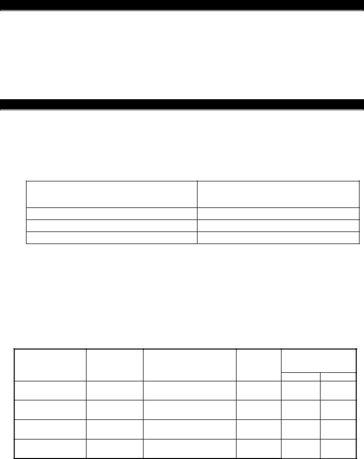
4 . R E S P O N S I B L E E N T I T Y / O R G A N I Z A T I O N
If the responsible organization is the Applicant located in No. 3 above, check here:
If the responsible organization is different from the Applicant in No. 3 above, complete the following:
Organization Name ________________________________________________ Telephone ( ) _________________
Mailing Address ____________________________________________________________________________________
City or Town_________________________________________ State ___________ Zip Code __________+_______
Fax ( ) _____________________________
Organization Type: |
Authority/District/Commission |
Municipal |
|
County |
State |
(Check one) |
Commercial/Industry |
Individually Owned |
Utility |
Corporation |
|
|
Investor |
Investor (BPU) |
Other ____________________ |
||
|
|
|
|
|
|
5 . B I L L I N G C O N T A C T |
|
|
|
|
|
Billing should go to mailing address of: |
|
|
|
|
|
Responsible Entity/Organization address in No. 4 |
Applicant/Operating Entities address in No. 3 |
||||
Name ______________________________________ |
Telephone ( |
) __________________________ |
|||
6 . O T H E R P E R M I T S / A G E N C I E S
Provide the following for any other state, local or federal permit that has been applied for in relation to this project.
Permit Type |
Application No./ Permit |
Application Application Status |
|
No./Relevant DEP No. |
Date |
Water Quality Management Plan Amendment
Safe Drinking Water System/Potable Water Supply Well or Intake
Hazardous Waste Management Program
Land Use Permits (Freshwater Wetlands, etc.)
Relevant Environmental Permits – Including Federal, State, & Local Approvals – Specify:
Is the project located within the New Jersey Pinelands Area? ___ Yes ___No
If this application includes a new source of supply, which is located in the New Jersey Pinelands Area, or is for an increase in allocation, then a Certificate of Filing from the New Jersey Pinelands Commission must be submitted with the application. The Pinelands Commission can be contacted at (609)
Page 2 of 12

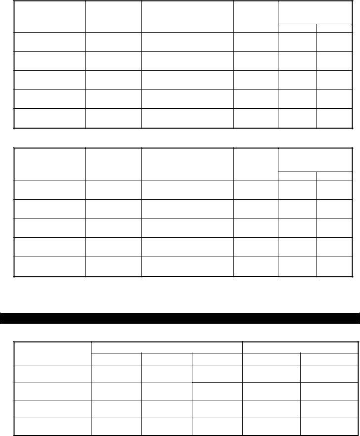
Is the project located in the Delaware River Basin? ___Yes |
___No |
If Yes, has a docket been issued for this project by the Delaware River Basin Commission?
___Yes |
Docket No. __________________ |
___No |
Docket applied for on _________________ (Date) |
The Delaware River Basin Commission can be contacted at (609)
B . C E R T I F I C A T I O N S
In cases where the official required to sign Certification 1 below is the same person as the official required to sign the Certification 2 below, only Certification 1 need be signed. In all other cases, both certifications shall be completed.
1 . H I G H E S T R A N K I N G I N D I V I D U A L O F F A C I L I T Y
This certification is to be signed by the
I certify under penalty of law that the information provided in this document is true, accurate and complete. I am aware that there are significant civil and criminal penalties for submitting false, inaccurate or incomplete information, including fines and/or imprisonment.
___________________ |
_____________________________________ |
Date |
Signature |
|
_____________________________________ |
|
Name (please print) |
|
_____________________________________ |
|
Title |
|
|
2 . H I G H E S T R A N K I N G I N D I V I D U A L |
|
This certification shall be signed as follows: |
|
(a)For a corporation, by a principal executive officer of at least the level of vice president; or
(b)For a partnership or sole proprietorship, by a general partner or the proprietor, respectively; or
(c)For a municipality, State, Federal or other public agency, by either the principal executive officer ranking elected official.
I certify under penalty of law that I have personally examined and am familiar with the information submitted in this application and all attached documents, and that based on my inquiry of those individuals immediately responsible for obtaining the information. I believe that the submitted information is true, accurate and complete. I am aware that there are significant civil and criminal penalties for submitting false, inaccurate or incomplete information, including the possibility of fines and/or imprisonment.
___________________ |
_____________________________________ |
Date |
Signature |
|
_____________________________________ |
|
Name (please print) |
|
_____________________________________ |
|
Title |
Page 3 of 12

3 . A P P L I C A N T ’ S A G E N T ( I F A P P L I C A B L E )
I, the Applicant/Owner __________________________________ or Applicant/Operator (when the owner of the
facility and the operator of the facility are distinct parties) __________________________________________
or
agent/representative in all matters pertaining to my application the following person:
Name ________________________________________ Phone _____________________________________
Company/Employer ________________________________________________________________________
Address ______________________________________ |
County ____________________________________ |
City or Town __________________________________ |
State _____________ Zip Code _______________ |
Occupation/Profession ______________________________________________________________________
|
_____________________________________ |
|
(Signature of Applicant/Owner) |
|
_____________________________________ |
|
(Signature of Applicant/Owner) |
|
_____________________________________ |
|
(Signature of |
AGENT’S CERTIFICATION |
|
Sworn before me |
|
this _____________ day of |
I agree to serve as agent for the above mentioned applicant |
_________________ 20 ______ |
|
___________________________ |
_____________________________________ |
Notary Public |
(Signature of Agent) |
4.STATEMENT OF PREPARER OF PLANS, SPECIFICATIONS, SURVEYORS OR TECHNICAL REPORT (IF APPLICABLE)
I hereby certify that the engineering plans, specifications and engineer's report applicable to this project comply with the current rules and regulations of the State Department of Environmental Protection with the exceptions as noted.
_____________________________________
(Signature of Engineer)
_____________________________________
Type: Name and Date
_____________________________________
Position, Name of Firm
PROFESSIONAL ENGINEER'S EMBOSSED SEAL
Page 4 of 12
C . R E Q U I R E D S U B M I T T A L S / A P P L I C A T I O N A T T A C H M E N T S
Check to ensure the following are included with the application:
Included |
|
|
|
|
|
|
1. |
Proof of Meter Calibration for each source |
|
|
|
|
2. |
Water conservation and Drought Management Plan |
|
If not required, please indicate why:______________________________________________ |
|
|
|
|
|
|
|
|
3. |
Information supporting Future Demands Projections listed in Section E.1. |
|
|
|
|
4. |
Send a PDF version of this application and attachments to: waterallocation@dep.nj.gov |
|
|
|
D . D I V E R S I O N R E Q U E S T A N D D I V E R S I O N S O U R C E I N F O R M A T I O N
This application is for:
Renewal of existing Permit No. ___________ Activity No. (if known) __________________
1.Present Allocation:
a. Groundwater: _______ million gallons of water per month at a maximum rate of ______ gallons per minute.
Please note the present Aquifer Specific Allocation:
Aquifer/Formation Name
Present Allocation (million gallons)
Per Month (mgm) |
Per Year (mgy) |
|
|
b. Surface water: |
_______ million gallons of water per month at a maximum rate of _______ gallons per minute. |
c. All sources: |
_______ million gallons of water per month at a maximum rate of _______ gallons per minute. |
d. All sources: |
_______ million gallons of water per year. |
Note: Monthly allocations are established based upon the maximum withdrawal expected during any one month (31 days) of the calendar year.
2.Diversion to be used for ________________________________________________________________________.
3.Complete the following for each diversion source: a. Groundwater (wells)
State Well Permit No.
(mandatory)
Well Local Name
Location Description
Existing (E) Proposed (P)
Proposed Maximum
Withdrawal Rate
(million gallons)
Per Month Per Year
1If source specific surface water allocations are requested, please attach requests as necessary.
Page 5 of 12
b. Groundwater (continued from previous page)
State Well Permit No.
(mandatory1)
Well Local Name
Location Description
Existing (E) Proposed (P)
Proposed Maximum
Withdrawal Rate
(million gallons)
Per Month Per Year
b. Surface water (streams, reservoirs, ponds)
Intake Subject Item Identification No. 2
Intake Local
Name
Location Description
Existing (E) Proposed (P)
Proposed Maximum
Withdrawal Rate
(million gallons)
Per Month Per Year
4. Complete Addendum A and B for each diversion source.
E . W A T E R U S E
1. The current and projected average and peak water demands in million of gallons for 5 year intervals are as follows:
WATER DEMAND
AVERAGE DEMAND
Daily |
Monthly |
Annual |
PEAK DEMAND
Daily |
Monthly |
Current Demand
5 Year Projections
10 Year Projections
15 Year Projections
1State Well Permit No. is mandatory for existing wells (see instructions).
2Intake Subject Item Identification No. is the identification number assigned to the intake by the DEP. For existing, approved sources, this number can be found on the
Page 6 of 12

2. Present annual average water use:
|
Self Supplied |
Other |
Total |
Estimated |
|
WATER USE |
Ground |
Surface |
Sources |
Consumptive Use1 |
|
|
(mgd) |
(mgd) |
(mgd) |
(mgd) |
(%) |
|
|
||||
|
|
|
|
|
|
Domestic Supply |
|
|
|
|
|
|
|
|
|
|
|
Industrial Process |
|
|
|
|
|
|
|
|
|
|
|
Industrial Cooling |
|
|
|
|
|
|
|
|
|
|
|
Irrigation |
|
|
|
|
|
|
|
|
|
|
|
Commercial |
|
|
|
|
|
|
|
|
|
|
|
Remediation |
|
|
|
|
|
|
|
|
|
|
|
Other |
|
|
|
|
|
|
|
|
|
|
|
Total Water Use |
|
|
|
|
|
|
|
|
|
|
|
1Consumptive use is water withdrawn that is not returned to the surface or ground waters at or near the point from which it was taken without substantial dimunition in quantity or substantial impairment of quality.
3.The water, after use for above purposes stated in D.2., will discharge into ___________________________________
(Name of Stream, Sewage System, or Subsurface Disposal System). For wastewater discharged directly by the facility or via a sewerage system to treatment plant, provide the location of the plant and its NJPDES Permit Number. Location:_______________________________________________________________________________________
NJPDES Permit No. ________________________
4.For
F . I R R I G A T I O N
Complete if water is to be used for irrigation purposes.
1. Check to ensure the following is included: Included
Attach a diagram of the irrigation system piping between the diversion sources, any storage ponds and wet wells, up to the irrigation system distribution piping. Include the position of all water meters.
2.Irrigation is to be used for (e.g. golf course, landscape, grounds maintenance)
______________________________________________________________________________________________
3.Describe the types of grasses, acreage and maximum need for each in extreme dry weather, in gallons per week.
______________________________________________________________________________________________
______________________________________________________________________________________________
______________________________________________________________________________________________
4.Describe the irrigation system (type, capacity of nozzles in gpm, maximum number of nozzles operating at one time, average and maximum irrigation time in hours per day, how diversion is metered, how the ponds are fed.)
______________________________________________________________________________________________
______________________________________________________________________________________________
______________________________________________________________________________________________
5. Is there any treated wastewater used for irrigation? ___Yes ___No
Page 7 of 12

G . P U B L I C W A T E R / S U P P L Y S Y S T E M S
Complete only if diversion is for public water supply.
1.Population
a.Population supplied at the time of application: ____________
b.Provide source or basis as to how figure in 1a. was determined: ______________________________________
c.The population supplied is projected to be ___________ by the year _______. The method used to calculate the population is (or include in attached report): _______________________________________________________
___________________________________________________________________________________________
2.Estimated Consumption (average day of maximum month (MGD)):
a.Immediate ________________
b.Future (_________ years) ____________
3.Quantity or percentage of water supplied during the last calendar year for the following:
|
Annual |
Maximum Month |
Total |
________________ |
________________ |
|
||
Domestic |
________________ |
________________ |
|
||
Commercial |
________________ |
________________ |
|
||
Industrial |
________________ |
________________ |
|
||
Other |
________________ |
________________ |
|
4.Quantity or percentage of
5. Number of Service Taps: |
Domestic |
________ |
Commercial and Industrial ___________ |
Number of Meters: |
Domestic |
________ |
Commercial and Industrial ___________ |
6.Capacity of Plant (gallons daily) _________________
7.Total System Storage (million gallons) _________________
8.The following is required for all Public Water Supply Applications:
Included |
|
|
|
|
|
|
a. |
Provide a list of all contracts with other municipalities or water companies to supply or purchase |
|
water. Provide copies of the all contracts not previously approved by the Bureau. |
|
|
|
|
|
|
|
|
b. |
List of municipalities to be supplied. Submit a map of the service area when not restricted by |
|
established municipal limits. (If not submitted previously.) |
|
|
|
|
|
|
|
|
c. |
List of all interconnections, size of each interconnection, and the water system serviced. |
|
|
|
|
d. |
Other drawings and information deemed pertinent. |
|
|
|
Page 8 of 12

ADDENDUM A
SOURCE DATA FOR GROUNDWATER (WELLS)
Complete Well information for all existing and proposed sources. This information is mandatory. Refer to instructions for acceptable values. Please reference the same State Well Permit Numbers and Well Names as referenced in Section D of the application. Attach additional copies of addendum as needed.
State Well Permit No.
Well Local Name
Date Drilled
Total Finished Depth (feet)
(include tailpiece if any)
Depth to Top of Open Hole
Interval or Screen (feet)
Depth to Bottom of Open Hole Interval or Screen (feet)
Rated Pump Capacity (gpm)
Yield (gpm)
Aquifer/Geological
Formation
Elevation Information:
Site Elevation
Elevation System
Description
Elevation Method
Description
Absolute Elevation
Accuracy
Absolute Elevation Accuracy Units (feet or meters)
Locational Information:
X coordinate (e.g.
Longitude) of well center
Y coordinate (e.g. Latitude) of well center
Coordinate System Code
and Description
Coordinate Method
Description
Absolute Location
Accuracy
Accuracy Units (feet or meters)
Addendum A Page ___ of ___
Page 9 of 12

ADDENDUM B
SOURCE DATA FOR SURFACE WATER (STREAMS, RESERVOIRS, PONDS)
Complete Intake information for all existing and proposed sources. This information is mandatory. Refer to instructions for acceptable values. Please reference the same Source Intake ID and Intake Local Name as referenced in Section D of the application. Attach additional copies of addendum as needed:
Source Intake SI ID (if already permitted)
Intake Local Name
Rated Pump Capacity (gpm)
MA7CD10 (cfs) at intake opening
Requested Passing Flow (cfs)
Surface Water Quality
Classification
Drainage Area Above
Intake (square miles)
Locational Information:
X coordinate (e.g. Longitude) of intake opening
Y coordinate (e.g. Latitude) of intake opening
Coordinate System Code
and Description
Coordinate Method
Description
Absolute Location
Accuracy
Accuracy Units (feet or meters)
Addendum B Page ___ of ___
Page 10 of 12

I N S T R U C T I O N S F O R C O M P L E T I N G B W A - 0 0 1B
1 . G E N E R A L I N S T R U C T I O N S
This form includes eight sections, A through H, and Addenda A and B. Section F applies to irrigation water users (other than Agricultural/Horticultural water users certified by the County Agricultural Agent under N.J.A.C.
applicable sections must be completed or the application will be returned.
Applications must reference valid State Well Permit Numbers and wells must be permitted for their intended use. A well search can be scheduled by the applicant or performed by the Department for a fee. Applications without valid State Well Permit
Numbers for existing wells will be returned.
All information required by the regulations under N.J.A.C.
A.Site Location Information
1.Actual Diversion Location - Provide the Name of the Facility of which the application is for, the physical street address or nearest cross streets of the diversion location. Attach additional sheets if more than one physical location applies.
2.Property/Land Owners – Provide the legal name for the owner of the property/land on which the diversion is located.
3.Applicant/Operating Entity(ies) – Provide the name, as it is legally referred to, of the operating entity of the subject facility. The operating entity is the firm, public agency, individual, or other entity which has the primary management and decision making authority over any part of the facility/site.
The Application Contact is the individual responsible for all aspects/inquiries regarding the application. Check the Agent box if an Agent has been designated in Section B3 of the Application. The Report Form Recipient/Permit Contact is the designated individual responsible for completing Quarterly Monitoring Report Forms. All Monitoring Report Forms will be mailed to the Report Form Recipient/Permit Contact designated at the Operating Entities address.
4.Responsible Entity/Organization – The person, company, or corporation financially responsible for the activity relating to the diversion and has overall legal responsibility of the activities occurring at the site. The organization liable or accountable for overall facility operations. The responsible entity may be the same as the Applicant/Operating Entity noted in Section A3. If so, check the appropriate box provided. If not, provide the requested information for the Responsible Entity
5.Billing Contact – Check the box of the appropriate address (either the Responsible Entity/Organization or the Applicant/Operating Entity) and indicate the individual contact for all billing inquiries.
6.Other Permits – Provide information for all other permits applied to in relation to the project and diversion activities, as indicated.
B.Certifications – Provide Certifications as indicated in Section B.
C.Required Submittals/Application Attachments
1.All diversion sources must be metered prior to treatment. Submit evidence to demonstrate that the flow meter for each source has been calibrated within the past five years. Also include the type of meter for each source. Evidence of meter calibration is not required for new sources (meters must be installed on all approved new sources, however). If the diversion is not metered at each source prior to treatment, please indicate why.
2.A completed Water Conservation and Drought Management Plan. Separate instructions and worksheets for completing the plan should be obtained by contacting the Bureau of Water Allocation & Well Permitting. A Conservation Plan is not required if the application is for ground water remediation, sand and gravel mining, or where diverted water is returned in undiminished quantity to its source.
3.Supporting information that shows how the future demands were determined in Section E.1. of the application.
For Sections D through G, please provide all information as requested in the section.
Page 11 of 12

2 . I N S T R U C T I O N S F O R C O M P L E T I N G A D D E N D A A A N D B
The following tables provide the acceptable values for completing Addenda A and B.
Elevation Information
Elevation System Description
Feet above sea level
Meters above sea level
Elevation Method Description
Approximate address match
DEP program database
Digital image
Exact address match
GPS
Hard copy match
Licensed Surveyor
Topographic Map
Plot Plan
Proposed
Proposed
Absolute elevation accuracy is the uncertainty in feet or meters of the elevation measurement.
Locational Information
USGS quadrangle maps have the coordinate system printed on the map. GPS units can usually be set to display a variety of coordinate systems. New Jersey State Plane 83 – USFEET is the State standard.
|
|
|
|
|
Coordinate |
Coordinate System Description* |
|
|
System Code |
|
|
|
22 |
Lat/Long (NAD27) – Decimal Degrees |
|
|
27 |
Lat/Long (NAD27) – DMS |
|
|
21 |
Lat/Long (NAD83) – Decimal Degrees |
|
|
20 |
Lat/Long (NAD83) – DMS |
|
|
09 |
New Jersey State Plane 27 – USFEET |
|
|
02 |
New Jersey State Plane 83 – Meters |
|
|
01 |
New Jersey State Plane 83 – USFEET |
|
|
26 |
UTM (NAD27) – Meters |
|
|
08 |
UTM Zone 18N – Meters |
|
|
03 |
UTM Zone 18N (78 W to 72 W) – Kilometers |
|
|
|
|
|
Coordinate Method Description
GPS
DEP Program Database
Exact Address Match
Digital Image (such as
Hard Copy Map
Other (Describe)
Approximate Address Match
Proposed Location - Digital Image (such as
Proposed Location - Hard Copy Map
*Coordinates obtained historically from BWA are likely to be Lat/Long (NAD27) – DMS
Absolute location accuracy is the uncertainty in feet or meters of the location from actual ground truth. Modern GPS units can provide this number.
Page 12 of 12