U.S. Department
Of Transportation
Federal Aviation
Administration
FAA Form 7480-1, Notice for Construction, Alteration and Deactivation of Airports
Paperwork Reduction Act Burden Statement
A federal agency may not conduct or sponsor, and a person is not required to respond to, nor shall a person be subject to a penalty for failure to comply with a collection of information subject to the requirements of the Paperwork Reduction Act unless that collection of information displays a currently valid OMB Control Number. The OMB Control Number for this information collection is 2120-0036. Public reporting for this collection of information is estimated to be approximately 60 minutes per response, including the time for reviewing instructions, searching existing data sources, gathering and maintaining the data needed, completing and reviewing the collection of information.
All responses to this collection of information are required if the proponent wishes to have the airport on file with the FAA, as required by Title 14 Code of Federal Regulations Part 157, and entered into the National Airspace System. No assurances of confidentiality are given. Send comments regarding this burden estimate or any other aspect of this collection of information, including suggestions for reducing this burden to: Information Collection Clearance Officer, Federal Aviation Administration, 10101 Hillwood Parkway, Fort Worth, TX 76177-1524.
When to File a Notice for Construction, Alteration and Deactivation of Airports
Title 14 Code of Federal Regulations Part 157 requires all persons to notify the FAA at least 90 days before construction, alteration, activation, deactivation, or change to the status or use of a civil or joint-use (civil/military) airport. (As used herein, the term “airport” means any Landing or Takeoff Area, e.g. Airport, Heliport, Vertiport, Gliderport, Seaplane Base, Ultralight Flightpark, or Balloonport.)
Notice is not required for:
1.An airport subject to conditions of a Federal agreement that requires an approved current airport layout plan to be on file with the Federal Aviation Administration.
2.Establishment of a temporary airport at which operations will be conducted under visual flight rule (VFR) and will be used for less than 30 days with no more than 10 operations per day.
3.Intermittent use of a site that is not an established airport, which is used for less than one year and at which flight operations will be conducted only under VFR. (Intermittent use means the use of the site for no more than 3 days in any one week and for no more than 10 operations per day.)
Required notice will be submitted on this form from each person who intends to do the any of the following:
1.Construct or otherwise establish a new airport or activate an airport.
2.Construct, alter, realign, or activate any runway, or other aircraft landing or takeoff area of an airport.
3.Construct, alter, realign, or activate a taxiway associated with a landing or takeoff area on a public-use airport.
4.Deactivate, discontinue using, or abandon an airport or any landing or takeoff area of an airport for a period of one year or more.

5.Deactivate, abandon, or discontinue using a taxiway associated with a landing or takeoff area on a public-use airport.
6.Change the status of an airport from private use (use by the owner or use by the owner and other person authorized by the owner) to an airport open to the public of from public-use to another status.
7.Change status from IFR (Instrument Flight Rules) to VFR or from VFR to IFR.
8.Establish or change any traffic pattern or traffic pattern altitude or direction.
Section 901 of the Federal Aviation Act of 1958, as amended, provides that any person who violates a rule, regulation, or order issued under Title III of this Act will be subject to a civil penalty not to exceed $1,000 for each violation.
General Instructions – Form Completion
Please contact the local ADO or Regional office for filing instructions.
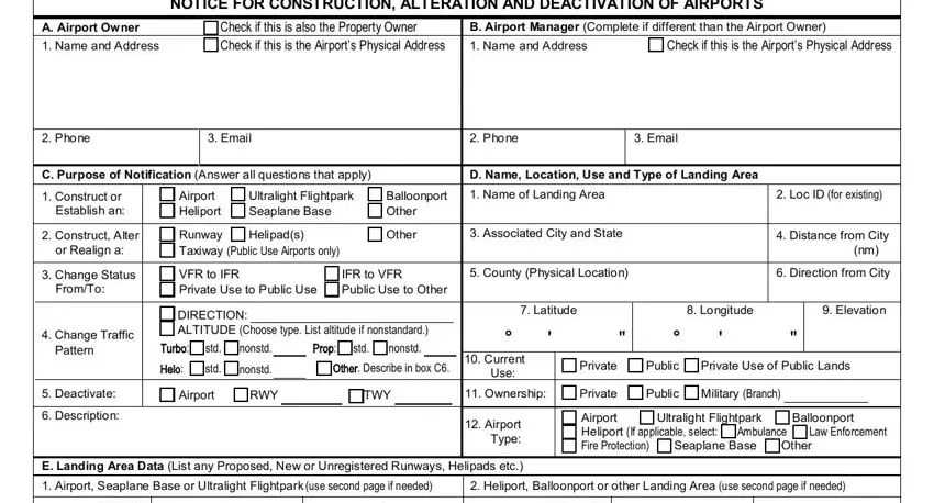
Section A – Complete this section.
•Provide the name of the Airport Owner.
•Include contact information (phone number, email address, and mailing address) of the Airport Owner.
•Indicate if the Airport Owner owns the airport property,
•Indicate if the Airport Owner’s address is the physical address of the airport. (If the Airport Owner’s address is not the physical address of the airport, provide the physical address of the airport in box C.6. Description.)
Section B – Complete this section if the Airport Manager is not the same person listed in section A.
•If the Airport Owner provided in Section A is the Airport Manager, write “SAME” in box B.1. Airport Manager.
•If the Airport Owner provided in Section A is not the Airport Manager, provide the name of the Airport Manager.
•Include contact information (phone number, email address, and mailing address) of the Airport Manager.
•Indicate if the Airport Manager owns the airport property.
•Indicate if the Airport Manager address is the physical address of the airport. (If the Airport Manager’s address is not the physical address of the airport, provide the physical address of the airport in box C.6. Description.)
Section C – Provide the reason for notification by completing all applicable items in this section. Report only one action per form
•Section C.1: Select one type of facility.
•Section C.2: Select one. For public-use taxiway, include information in box C.6. Description and depict taxiway layout on airport drawing or sketch.
•Section C.3: Select one. If change is from VFR to IFR, include anticipated IFR procedure in box 6. Description.
•Section C.4: Indicate if the change is to Direction and/or Altitude.
OIf Direction, indicate the new direction.
OIf Altitude, find the type(s) changed and indicate if the change is to standard or nonstandard for each type changed. If nonstandard, indicate the nonstandard altitude. If Other, describe the change in box C6.
•Section C.5: Provide appropriate information and include abandonment date in box 6. Description.
Section D – Provide all applicable information.
•Section D.1: Enter name of landing area.
•Section D.2: Enter the Location Identifier (Loc ID) for an existing Airport.
•Section D.3: Enter principle city or town which the airport serves and with it is normally associated.
•Section D.4: Enter straight-line distance and direction, to the nearest nautical mile, from the Associated City (C.3. above) to the Airport.
•Section D.6: Enter the direction, to the nearest eighth compass point (i.e. E, SE, etc.), from the Associated City to the Airport.
•Section D.7, 8, and 9: Enter the Latitude and Longitude of the Airport Reference Point and the Airport Elevation. The airport reference point can be calculated by using the NGS tool located at NOAA (http://www.ngs.noaa.gov/AERO/arpcomp/arpframe.html). The Airport elevation is the highest point of an airport's usable runways measured in feet above mean sea level.
•Section D.10: Select one Current Use option.
•Section D.11: Select one Ownership option.
•Section D.12: Select primary Airport Type. If Heliport, choose (if applicable) Ambulance, Law Enforcement, or Fire Protection. Choose these options only if Heliport is the primary airport type.
Section E – Provide all applicable information.
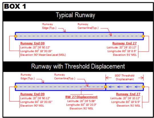
•Section E.1: Address each runway end independently, if applicable. Provide runway end coordinates and elevations; and runway threshold coordinates and elevations for runway
threshold displacements, if applicable (see an example Box 1 below).
▪Section E.2: If helipad is elevated, provide the elevated height above ground level (AGL) and do not add the AGL height to Above Mean Sea Level (AMSL). For Heliports, include the TLOF (Touchdown and Liftoff Area) and FATO (Final Approach and Take Off) dimensions.
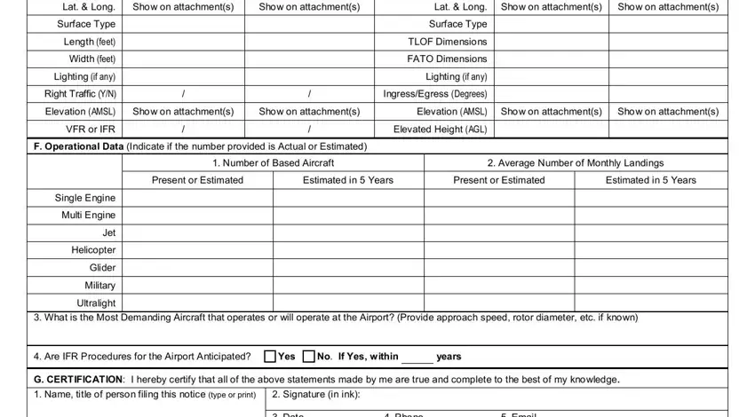
Section F – Provide all applicable information.
Section G – All information is required and must be complete.
•For an Airport/Runway: Provide a detailed drawing and/or imagery of the proposed landing area depicting latitude, longitude, length, and width.
OThe document(s) must show the runway orientation in relation to known roads, terrain etc. such that the FAA can locate the runway(s) accurately and efficiently.
ONotate any obstructions (buildings, high-line wires, roads, railroads, towers, etc.) near the runway.
OYou must include runway end coordinates and the runway elevations on the runway centerline.
•For a Heliport: Provide a detailed drawing, imagery or map identifying the exact location of the heliport in red.
OThe document(s) must show the helipad(s) in relation to known roads, terrain etc. such that the FAA can locate the heliport accurately and efficiently.
OProvide site plan depicting the landing pad in relation to buildings and other obstacles (light poles, fences, trees, bollards, parking lots) near the landing area.
OProvide dimensions of the landing pad and the height of the buildings/obstacles and their distance from the helipad.
OProvide a heliport layout plan (in accordance with FAA Advisory Circular 150/5390-2, Heliport Design) identifying the proposed marking, lights, beacon location, windsock(s), the approach/departure paths (if room allows, the heliport layout plan may be shown on the site plan).
Notification to the FAA does not waive the requirements of any other government agency.