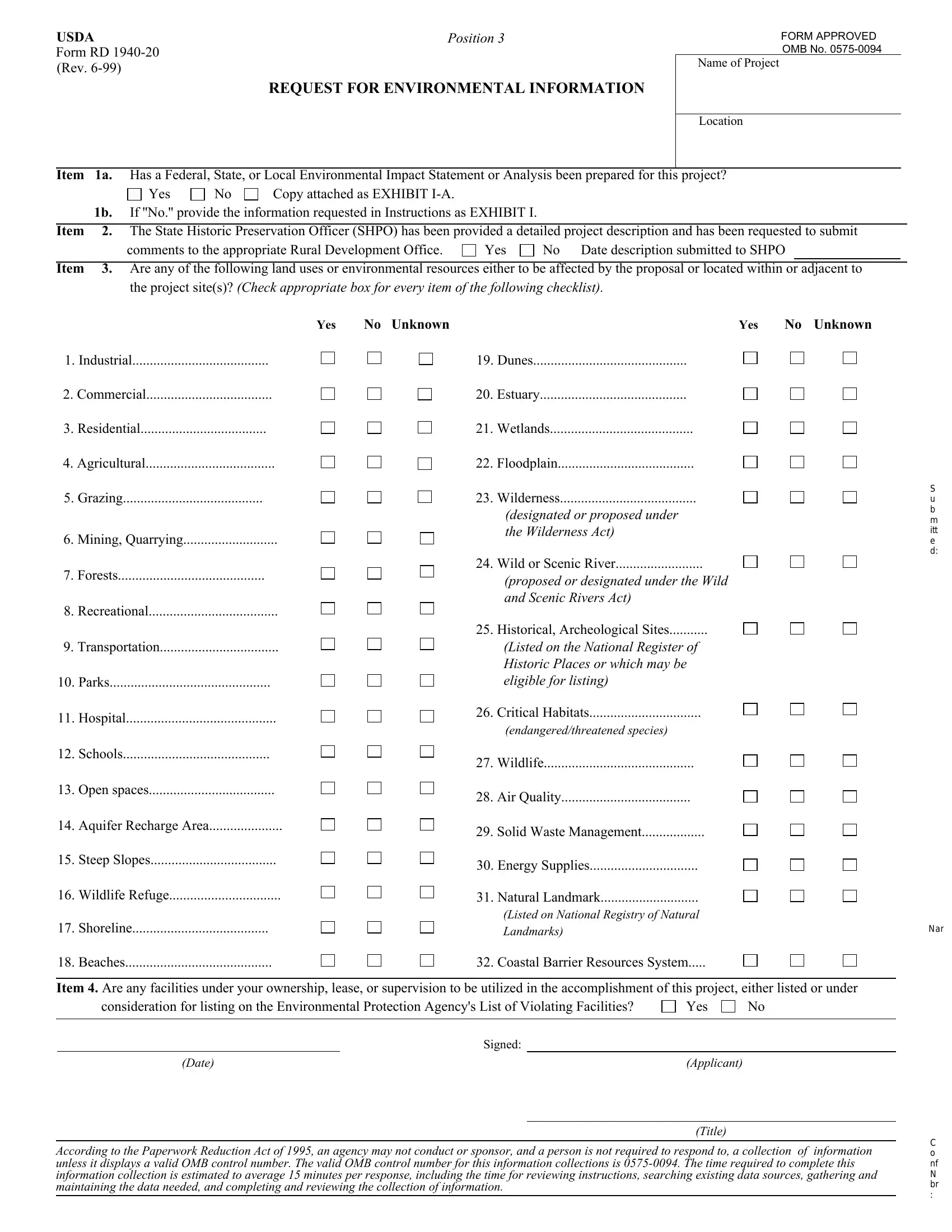
Form RD 1940-20 (Rev. 6-99)
REQUEST FOR ENVIRONMENTAL INFORMATION
FORM APPROVED
OMB NO. 0575-0094
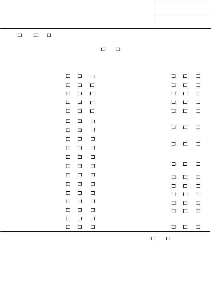
Name of Project
Location
ITEM |
1A. |
Has a Federal, State, or Local Environmental Impact Statement or Analysis been prepared for this project? |
|
|
Yes |
No |
Copy attached as EXHIBIT I-A. |
|
|
|
|
|
|
1B. |
If ''No.'' provide the information requested in Instructions as EXHIBIT I. |
|
|
|
|
|
|
|
|
|
ITEM |
2. |
The State Historic Preservation Officer (SHPO) has been provided a detailed project description and has been requested to submit |
|
|
comments to the appropriate Rural Development Office. |
Yes |
No |
Date description submitted to SHPO |
|
|
|
|
|
|
|
|
|
|
ITEM |
3. |
Are any of the following land uses or environmental resources either to be affected by the proposal or located within or adjacent to |
|
|
the project site(s)? (Check appropriate box for every item of the following checklist). |
1.Industrial.......................................
2.Commercial....................................
3.Residential....................................
4.Agricultural.....................................
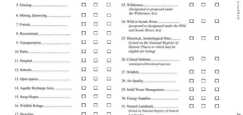
5.Grazing........................................
6.Mining, Quarrying...........................
7.Forests..........................................
8.Recreational.....................................
9.Transportation..................................
10.Parks..............................................
11.Hospital...........................................
12.Schools..........................................
13.Open spaces....................................
14.Aquifer Recharge Area.....................
15.Steep Slopes....................................
16.Wildlife Refuge................................
17.Shoreline.......................................
18.Beaches..........................................
YES |
NO UNKNOWN |
YES |
NO UNKNOWN |
|
19. Dunes |
|
|
20. |
Estuary |
|
|
21. |
Wetlands |
|
|
22. |
Floodplain |
|
|
23. |
Wilderness |
|
|
|
(designated or proposed under |
|
|
|
the Wilderness Act) |
|
|
24. Wild or Scenic River |
|
|
|
(proposed or designated under the Wild |
|
|
|
and Scenic Rivers Act) |
|
|
25. |
Historical, Archeological Sites |
|
|
|
(Listed on the National Register of |
|
|
|
Historic Places or which may be |
|
|
|
eligible for listing) |
|
|
26. |
Critical Habitats |
|
|
|
(endangered/threatened species) |
|
|
27. |
Wildlife |
|
|
28. |
Air Quality |
|
|
29. |
Solid Waste Management |
|
|
30. Energy Supplies |
|
31. Natural Landmark............................
(Listed on National Registry of Natural Landmarks)
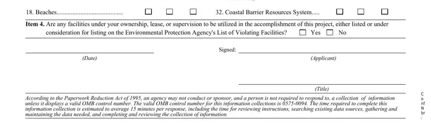
32. Coastal Barrier Resources System.....
ITEM 4. Are any facilities under your ownership, lease, or supervision to be utilized in the accomplishment of this project, either listed or under
consideration for listing on the Environmental Protection Agency's List of Violating Facilities? |
Yes |
No |
|
|
|
|
|
|
Signed: |
|
|
|
(Date) |
(Applicant) |
|
|
|
|
|
|
|
|
|
(Title) |
|
|
|
|
|
|
According to the Paperwork Reduction Act of 1995, an agency may not conduct or sponsor, and a person is not required to respond to, a collection of information unless it displays a valid OMB control number. The valid OMB control number for this information collections is 0575-0094. The time required to complete this information collection is estimated to average 15 minutes per response, including the time for reviewing instructions, searching existing data sources, gathering and maintaining the data needed, and completing and reviewing the collection of information.
INSTRUCTIONS FOR PREPARING FORM RD 1940-20
Federal agencies are required by law to independently assess the expected environmental impacts associated with proposed Federal actions. It is extremely important that the information provided be in sufficient detail to permit Rural Department to perform its evaluation. Failure to provide sufficient data will delay agency review and a decision on the processing of your application.
This information request is designed to obtain an understanding of the area’s present environmental condition and the project’s elements that will affect the environment. Should you believe that an item does not need to be addressed for your project, consult with the RD office from which you received this Form before responding. In all cases when it is believed that an item is not applicable, explain the reasons for this belief.
It is important to understand the comprehensive nature of the information requested. Information must be provided for a) the site(s) where the project facilities will be constructed and the surrounding areas to be directly and indirectly affected by its operation and b) the areas affected by any primary beneficiaries of the project. The amount of detail should be commensurate with the complexity and size of the project, and the magnitude of the expected impact. Some examples:
A small community center project may not require detailed information on air emissions, meteorological conditions and solid waste management.
A water resource, industrial development, or housing development project will require detailed information.
Item la - Compare the Environmental Impact Statement or Analysis that was previously prepared with the information requested in the instructions for Item lb below to be sure that every point in the information request is covered in the Environmental Impact Statement or Analysis. If any of the requested information is not covered, attach to the Environmental Impact Statement or Analysis a supplemental document that corrects any deficiencies or omissions.
Item lb - Provide responses to the following items in the order listed and attach as EXHIBIT I. In order to understand the full scope of the land uses and environmental factors that need to be considered in responding to these items, it may be helpful to complete Item 3 of the Form before completing these narrative responses. If your application is for a project that Rural Development has classified as a Class I action, complete only parts (1), (2), (13), (15), (16), and (17) of this Item. The Rural Development office from which you received this Form can tell you if your application falls within the Class I category.
(1)Primary Beneficiaries
Identify any existing businesses or major developments that will benefit from the proposal, and those which will expand or locate in the area because of the project. These businesses or major developments hereafter will be referred to as primary beneficiaries.
Page 2
(2)Area Description
(a)Describe the size, terrain, and present land uses as well as the adjacent land uses of the areas to be affected. These areas include the site(s) of construction or project activities, adjacent areas, and areas affected by the primary beneficiaries.
(b)For each box checked “Yes” in item 3, describe the nature of the effect on the resource. If one or more of boxes 17 through 22 is checked “Yes” or “Unknown,” contact Rural Development for instructions relating to the requirements imposed by the Floodplain Management and Wetland Protection Executive Orders.
(c)Attach as Exhibit II the following: 1) a U.S. Geological Survey “15 minute” (“7 1/2 minute” if available) topographic map which clearly delineates the area and the location of the project elements; 2) the Federal Emergency Management Administration’s floodplain map(s) for the project area; 3) site photos; 4) if completed, a standard soil survey for the project area; and 5) if available, an aerial photograph of the site. If a floodplain map is not available, contact Rural Development for additional instructions relating to the requirements imposed by the Floodplain Management Executive Order.
(3)Air Quality
(a)Provide available air quality data from the monitoring station(s) either within the project area or, if none exist nearest the project area.
(b)Indicate the types and quantities of air emissions to be produced by the project facilities and its primary beneficiaries. If odors will occur, indicate who will be affected.
(c)Indicate if topographical or meteorological conditions hinder the dispersal of air emissions.
(d)Indicate the measures to be taken to control air emissions.
(4)Water Quality
(a)Provide available data on the water quality of surface or underground water in or near the project area.
(b)Indicate the source, quality, and available supply of raw water and the amount of water which the project is designed to utilize.
(c)Describe all of the effluents or discharges associated with the project facilities and its primary beneficiaries. Indicate the expected composition and quantities of these discharges prior to any treatment processes that they undergo and also prior to their release into the environment.
Page 3
(d)Describe any treatment systems which will be used for these effluents and indicate their capacities and their adequacy in terms of the degree and type of treatment provided. Indicate all discharges which will not be treated. Describe the receiving waters and their uses (e.g., recreational) for any sources of treated and untreated discharge.
(e)If the treatment systems are or will be inadequate or overloaded, describe the steps being taken for necessary improvements and their completion dates.
(f)Describe how surface runoff will be handled if not discussed in (d) above.
(5)Solid Waste Management
(a)Indicate the types and quantities of solid wastes to be produced by the project facilities and its primary beneficiaries.
(b)Describe the methods for disposing of these solid wastes plus the useful life of such methods.
(c)Indicate if recycling or resource recovery programs are or will be used.
(6)Transportation
(a)Briefly describe the available transportation facilities serving the project area.
(b)Describe any new transportation patterns which will arise because of the project.
(c)Indicate if any land uses, such as residential, hospitals, schools or recreational, will be affected by these new patterns.
(d)Indicate if any existing capacities of these transportation facilities will be exceeded. If so, indicate the increased loads which the project will place upon these facilities, particularly in terms of car and truck traffic.
(7)Noise
(a)Indicate the major sources of noise associated with the project facilities and its primary beneficiaries.
(b)Indicate the land uses to be affected by this noise.
(8)Historic/Archeological Properties
(a)Identify any known historic/archeological resources within the project area that are either listed on the National Register of Historic Places or considered to be of local and state significance and perhaps eligible for listing in the National Register.
(b)Attach as EXHIBIT III any historical/archeological survey that has been conducted for the project area.
Page 4
(9)Wildlife and Endangered Species
(a)Identify any known wildlife resources located in the project area or its immediate vicinity.
(b)Indicate whether to your knowledge any endangered or threatened species or critical habitat have been identified in the project area or its immediate vicinity.
(10)Energy
(a)Describe the energy supplies available to the project facilities and the primary beneficiaries.
(b)Indicate what portion of the remaining capacities of these supplies will be utilized.
(11)Construction
Describe the methods which will be employed to reduce adverse impacts from construction, such as noise, soil erosion and siltation.
(12)Toxic Substances
(a)Describe any toxic, hazardous, or radioactive substances which will be utilized or produced by the project facilities and its primary beneficiaries.
(b)Describe the manner in which these substances will be stored, used, and disposed.
(13)Public Reaction
(a)Describe any objections which have been made to the project.
(b)If a public hearing has been held, attach a copy of the transcript as EXHIBIT IV. If not, certify that a hearing was not held.
(c)Indicate any other evidence of the community’s awareness of the project such as through newspaper articles or public notification.
(14)Alternatives to the Proposed Project
Provide a description of any of the following types of alternatives which were considered:
(a)Alternative locations.
(b)Alternative designs.
(c)Alternative projects having similar benefits.
Page 5
(15)Mitigation Measures
Describe any measures which will be taken to avoid or mitigate any adverse environmental impacts associated with the project.
(16)Permits
(a)Identify any permits of an environmental nature which are needed for the project.
(b)Indicate the status of obtaining each such permit and attach as EXHIBIT V any that have been received.
(17)Other Federal Actions
Identify other federal programs or actions which are either related to this project or located in the same geographical area and for which you are filing an application, have recently received approval, or have in the planning stages.
Item 2 - All applicants are required to provide the State Historic Preservation Officer (SHPO) with (a) a narrative description of the project’s elements and its location, (b) a map of the area surrounding theproject which identifies the project site, adjacent streets and other identifiable objects, (c) line drawings or sketches of the project and (d) photographs of the affected properties if building demolition or renovation is involved. This material must be submitted to the SHPO no later than submission of this Form to Rural Development . Additionally, the SHPO must be requested to submit comments on the proposed project to the Rural Development office processing your application.
Item 3 - Self-explanatory.
Item 4 - Self-explanatory.