Blm Form 3150 4 PDF Details

The BLM Form 3150-4 is a Inventory of Wildlife Habitat on Federal Lands form. This form is used to inventory wildlife habitats and populations on federal lands. The form is also used to document the effects of management activities on wildlife resources. The BLM Form 3150-4 must be completed for all projects that may affect fish, wildlife, or their habitat. The form can be completed by a variety of people, including biologists, land managers, and environmental technicians. Completion of the form helps ensure that project impacts are minimized and that mitigation measures are implemented when necessary.

QuestionAnswer
Form NameBlm Form 3150 4
Form Length3 pages
Fillable?No
Fillable fields0
Avg. time to fill out45 sec
Other namesfalse, 2-D, blm form 2800 16, Shothole

Form Preview Example

BLM Form 3150-4 FS Form 2800-16 (September 2013)

UNITED STATES

DEPARTMENT OF THE INTERIOR

BUREAU OF LAND MANAGEMENT

DEPARTMENT OF AGRICULTURE

FOREST SERVICE

NOTICE OF INTENT AND AUTHORIZATION TO CONDUCT OIL AND GAS GEOPHYSICAL EXPLORATION OPERATIONS

FORM APPROVED OMB NO. 1004-0162 Expires: July 31, 2015

NOI Case File No.

Project Name

Lessee or Operator


Lessee or Operator Representative


Address


Do you have a bond on file with the Agency?

Yes


No

City


State

Which Agency holds the bond?

BLM


Forest Service

Zip Code

Phone No. (Include area code)

Bond No.


Bond Amount: $

Email Address


Geophysical Co.


Geophysical Co. Representative


Address


Address


City


State

City


State


Zip Code

Phone No. (Include area code)

Zip Code

Phone No. (Include area code)


Representative’s Email Address

Cell Phone No. (Include area code)


Party Chief/Project Point of Contact (POC)

POC Contact Information

A separate Plan of Operations is attached addressing the items below


Yes


No.

1.Location Description and Maps: Give the general land description of the lands involved, limited to Meridian, Township, Range, and Section(s) or metes and bounds as appropriate. You must also submit an electronic map (in PDF) with a minimum scale of one-half inch per mile showing the general area and project location. We recommend a PDF version of a 7 1/2-minute USGS quadrangle or the scale commonly used in the area. In addition, you must submit GIS data in a locally projected Universal Transverse Mercator (UTM) North American Datum (NAD) 1983 ESRI shape file or geodatabase format (e.g., UTM zone 13N NAD83). For seismic operations, your data must include clearly attributed locations of operations and facilities, including staging areas, access routes to and within the project area, source and receiver point locations and lines, shot point locations, surface ownership, and any Federal lands under lease. You must identify the number of acres within the project area by Federal surface (by agency), state surface, fee surface, and other, and the estimated acreage of surface disturbance.

2.Do you hold any Federal leases within the project area? Yes No (If yes, indicate location and lease numbers on an attached map.) There is no fee for operations conducted on your Federal lease (outside of Alaska).

3.If you are proposing seismic exploration, how many miles of source line (2-D), or acres (3-D) (to the nearest 10 acres) of survey are on:

a.Your Federal Lease ________________________________________ b. Other Federal lands _________________________________________

4.When do you expect to start exploration? _____________________________________ How long will the project last? ____________ days. Describe any of your critical timeframes associated with the proposed project, such as equipment or contractor availability.

Title 18 U.S.C. Section 1001 and Title 43 U.S.C. Section 1212 make it a crime for any person knowingly and willfully to make to any Department or agency of the United States any false, fictitious, or fraudulent statements or representations as to any matter within its jurisdiction.

(Continued on page 2

Description and Type of Operations (check all that apply);

a. Survey Type:


2-D


3-D


Gravity/Magnetic


Other (explain):

Describe the survey type:

b. Survey Method:


Shot hole


Vibroseis


Other (explain):


For shot holes:

What type and amount of explosives per source will you use?

What shot point pattern and spacing will you use?

What will be the shot hole depth?

What type of receivers (wired/wireless) will you use and how will they be transported and placed?

What will be the receiver and source spacing (in feet) and spacing between the source and receiver (in feet)?

Describe the survey method:

c. Seismic Source and Transport Methods:


Vibroseis Trucks


Pick-up Truck


Drill Buggy


ATV


Helicopter


Backpack

Describe your seismic source and transportation

plans, including types of vehicles, numbers of vehicles for each aspect of the project, routes, and methods you

will use to access the project area:


d. Operating Procedures: Describe your operating procedures, including how you will minimize surface impacts and ensure compliance with the Terms and Conditions of this NOI. Describe staging areas and support facilities you need, such as helispots, temporary camps, equipment storage; fuel storage; powder magazines; construction of roads or trails; proposed plugging procedures for shot holes; waste management and spill prevention; reclamation; and general clean-up procedures.

(Continued on page 3)

(BLM Form 3150-4 and FS Form 2800-16, page 2)

Terms and Conditions

1.The Bureau of Land Management (BLM) or Forest Service (FS) (Agency) must approve any Surface disturbing activities in addition to those approved in the NOI, such as route changes, placement of magazines, towing with a tractor, blading, dozing, snow removal, and vegetation removal. I must notify the Agency in writing of any changes in the original proposal and have Agency approval in writing for the changes before proceeding with them. Stacking sourcepoints to avoid sensitive resources or areas does not require prior Agency approval.

2.This NOI expires on ________________________, unless the Agency extends it in writing before that date.

3.I understand that this NOI does not grant any exclusive right to the described lands for geophysical exploration, or other purposes. The land area described above is at all times subject to any other lawful uses by the United States, its lessees, permittees, licensees, and assigns.

4.I must notify the Agency at least _________ days, but no more than

________ days, prior to initiating the project and entering upon the public lands.

5.In the field, each seismic crew must have with it a copy of the approved NOI and its terms and conditions.

6.The Agency may suspend or terminate this NOI if there is a violation of any of its conditions.

7.I must suspend operations when the operations may unnecessarily damage the surface, such as when rutting would occur due to wet soil conditions.

8.I must indemnify the United States for any liability for damage to life or property resulting from the occupancy or use of public lands under the NOI.

9.I must take all reasonable precautions to prevent and must suppress fires. The Agency may specify in writing the fire prevention and firefighting equipment I need. At my expense, I must extinguish all fires set or caused as a result of operations under this NOI and must report all fires to the Agency.

10.I must diligently protect from unnecessary damage United States land and property covered by this NOI. I must pay the United States for any damage resulting from my or my agents’ or employees’ violation of the terms of this NOI or any law or regulation applicable to the lands involved.

11.I must store and handle powder magazines and explosives according to the U. S. Bureau of Alcohol, Tobacco and Firearms standards (see 27 CFR Part 55). I must properly secure loaded shot holes.

12.I must complete shot hole plugging under Agency guidelines and the guidelines of any other local, Federal or State regulatory authority.

13.I must remove all materials and equipment I placed on the premises and restore the site to the Agency’s satisfaction immediately after I complete the project unless the Agency approves other arrangements.

14.I must file a Notice of Completion (NOC) Form 3150-5/2800-16a within 30 days after completing operations and reclamation. If the location of the project is different from that in the approved NOI, I must submit a revised map with the NOC (1:24,000 scale, where available), including source points.

15.I must pay to the United States $_______________________ per

__________________________according to the regulations.

16.This geophysical exploration project is subject to the attached Conditions of Approval ____________________________ through

______________________ and Exhibits _____________________.

WARNING: If you purposely give false or misleading information, you may be fined $10,000, sent to prison, or both (see Title 18 U.S.C. 10001 statement on page 1).

I agree that I and my agents must conduct the geophysical exploration under all Federal, State and local laws, and applicable regulations and must comply with this NOI and any attached terms and conditions.

Printed Name of Authorized Company Representative


Signature of Authorized Company Representative


Date


Printed Name of Agency Signing Officer

Signature of Agency Signing Officer

Title of Agency Signing Officer


Date


NOTICES

The Privacy Act and 43 CFR 2.48(d) require that you be furnished the following information in connection with information request by this form.

AUTHORITY: The Mineral Leasing Act (30 U.S.C. 181 – 287), Mineral Leasing Act for Acquired Lands (30 U.S.C. 341 – 359), Federal Land Policy and Management Act of 1976 (43 U.S.C. 1701 – 1782), and National Environmental Policy Act (42 U.S.C. 4321 – 4347) permit collection of the information requested by this form. The BLM collects this information in accordance with 43 CFR parts 3150 and 3160. The FS collects this information in accordance with 36 CFR part 228.

PRINCIPAL PURPOSE: The BLM or the FS will use the information to process your notice and inform you of the terms and conditions under which geophysical exploration operations may be conducted.

ROUTINE USES: The BLM will only disclose the information in accordance with the Freedom of Information Act, the Privacy Act, and the provisions at 43 CFR 2.56(b) and (c). The FS will only disclose the information in accordance with the Freedom of Information Act, the Privacy Act, and the provisions at 36 CFR 200.7 and 7 CFR 1.1.

EFFECT OF NOT PROVIDING INFORMATION: Submission of the requested information is necessary to obtain or retain a benefit. Failure to submit all of the requested information or to complete this form may result in delay or result in revocation of your right to conduct geophysical exploration operations.

The Paperwork Reduction Act requires us to inform you that:

The BLM/FS collects this information in accordance with the statutes and regulations listed above, and for the purposes listed above. Submission of the requested information is necessary to obtain or retain a benefit.

You do not have to respond to this or any other Federal agency-sponsored information collection unless it displays a currently valid OMB control number.

BURDEN HOURS STATEMENT: The public reporting burden for this form is 1 hour per response, including the time for reviewing instructions, gathering and maintaining data, and completing and reviewing the form. You may submit comments regarding the burden estimate or any other aspect of this form to U.S. Department of the Interior, Bureau of Land Management (1004-0162), 1849 C Street, NW, Room 2134LM, Attention: Information Collection Clearance Officer, Washington, D. C. 20240.

(BLM Form 3150-4 and FS Form 2800-16, page 3)

How to Edit Blm Form 3150 4 Online for Free

Using PDF documents online is certainly very simple with our PDF tool. Anyone can fill out Shothole here painlessly. To maintain our tool on the cutting edge of practicality, we strive to implement user-oriented features and enhancements on a regular basis. We're at all times happy to get suggestions - play a pivotal part in remolding PDF editing. This is what you'd want to do to get started:

Step 1: Press the orange "Get Form" button above. It will open up our pdf editor so you can start filling out your form.

Step 2: When you access the PDF editor, you will see the document prepared to be filled out. Other than filling out different blanks, you may also do some other things with the Document, such as writing your own words, modifying the original textual content, adding graphics, affixing your signature to the document, and much more.

For you to complete this PDF form, ensure that you type in the required details in each and every blank:

1. While filling in the Shothole, be certain to complete all important blank fields in their corresponding section. This will help to speed up the work, allowing for your details to be processed swiftly and correctly.

form 2800 16 conclusion process shown (stage 1)

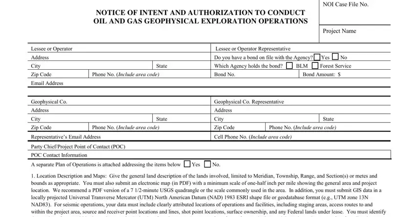
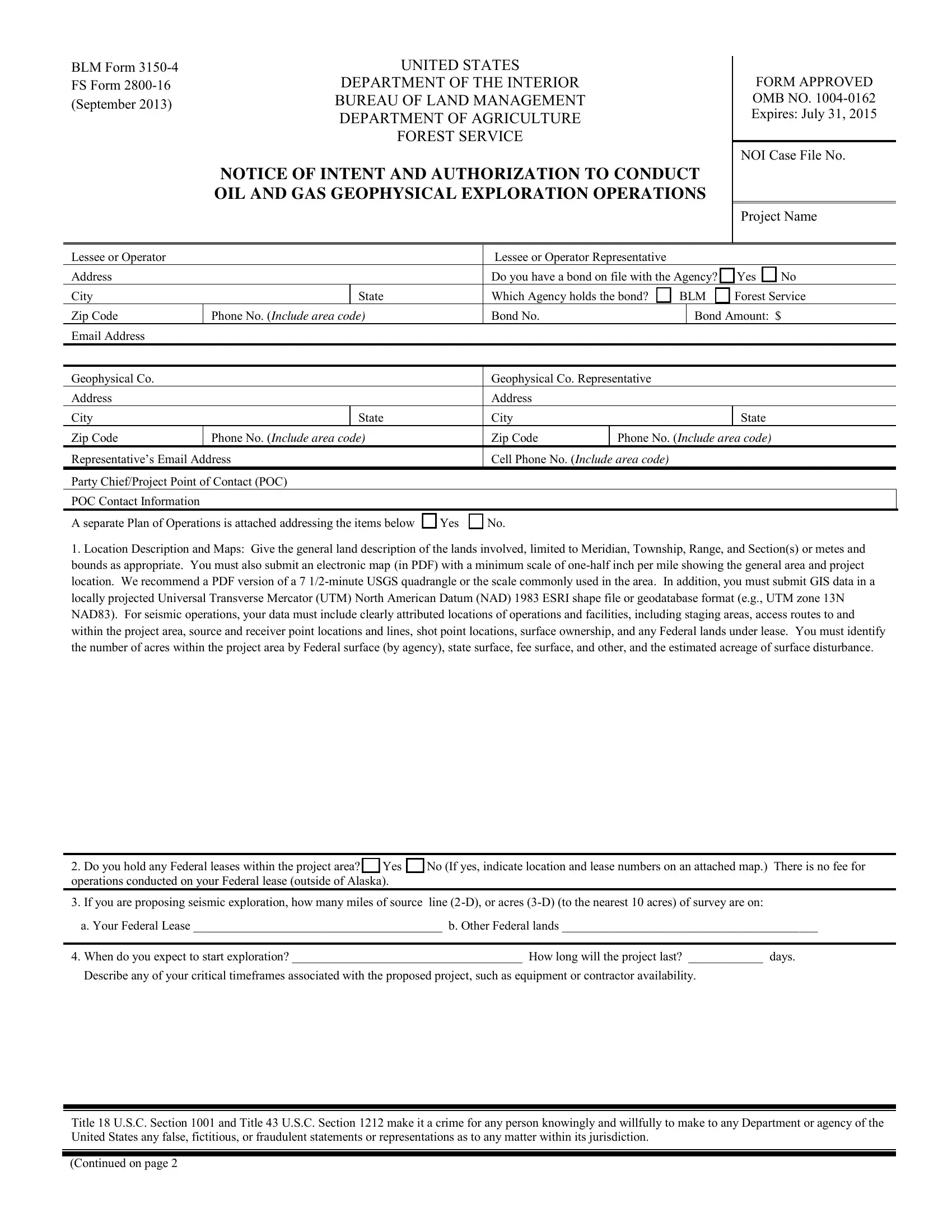
2. Once your current task is complete, take the next step – fill out all of these fields - Location Description and Maps, Do you hold any Federal leases, When do you expect to start, Title USC Section and Title USC, and Continued on page with their corresponding information. Make sure to double check that everything has been entered correctly before continuing!

Stage # 2 in filling in form 2800 16

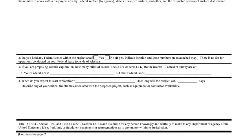
Concerning When do you expect to start and Do you hold any Federal leases, be sure that you take a second look in this section. These are certainly the most significant ones in this PDF.

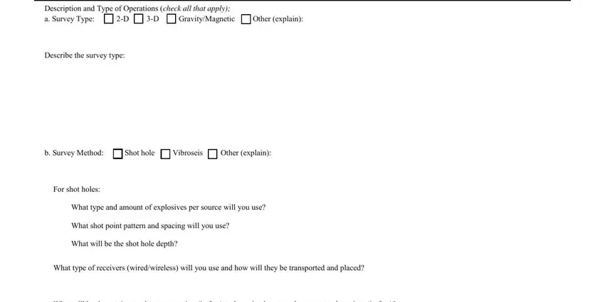
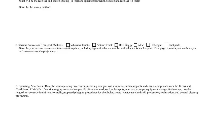
3. Completing Description and Type of Operations, Describe the survey type, b Survey Method Shot hole, For shot holes, What type and amount of explosives, What shot point pattern and, What will be the shot hole depth, What type of receivers, and What will be the receiver and is essential for the next step, make sure to fill them out in their entirety. Don't miss any details!

Completing section 3 in form 2800 16

4. It is time to fill out the next part! In this case you'll get these What will be the receiver and, Describe the survey method, c Seismic Source and Transport, Describe your seismic source and, and d Operating Procedures Describe blanks to do.

form 2800 16 completion process clarified (part 4)

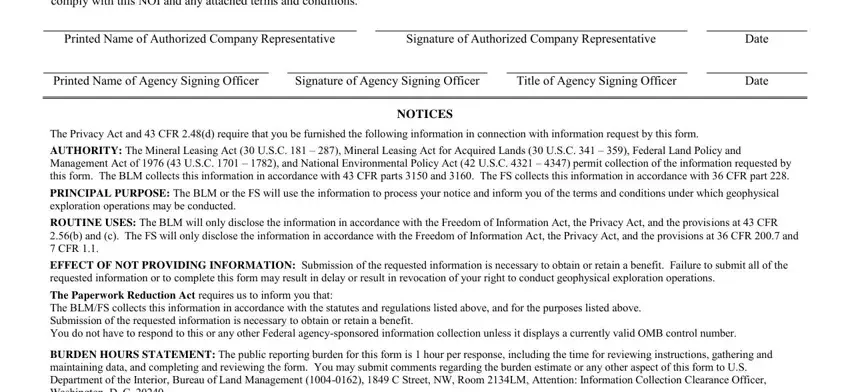
5. To conclude your form, the final part includes a few additional blanks. Entering I agree that I and my agents must, Printed Name of Authorized Company, Signature of Authorized Company, Date, Date, Printed Name of Agency Signing, Signature of Agency Signing Officer, Title of Agency Signing Officer, NOTICES, and The Privacy Act and CFR d require will certainly conclude the process and you'll be done in a snap!

NOTICES, Date, and Title of Agency Signing Officer inside form 2800 16

Step 3: After proofreading your entries, press "Done" and you're done and dusted! Go for a free trial plan at FormsPal and acquire direct access to Shothole - download or edit in your FormsPal account page. At FormsPal.com, we do our utmost to be sure that all of your details are stored protected.