
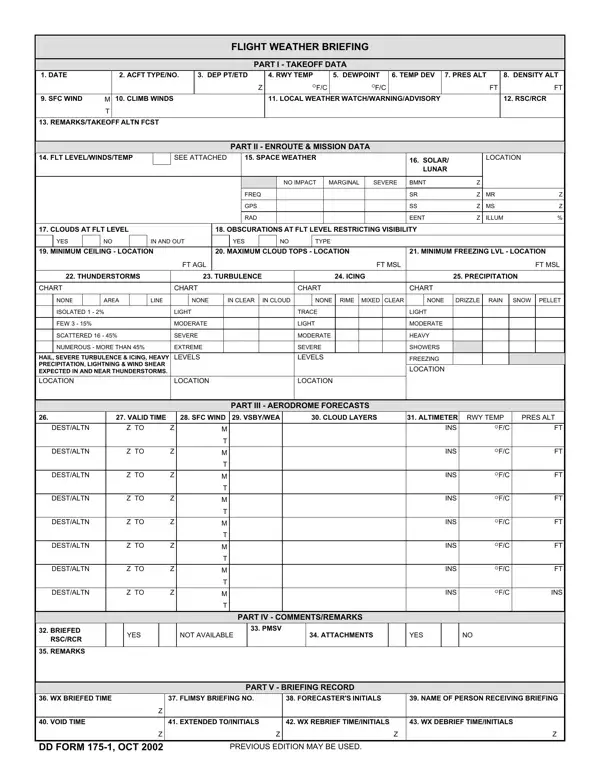
The DD Form 175-1 (Flight Weather Briefing) is an official U.S. Department of Defense aviation document. Military pilots, navigators, and aviation weather forecasters use it to record all weather information required before a military flight departs. Completing the form creates a shared record between the flight crew and the operations center that confirms a formal weather briefing took place.
Part I of the form covers takeoff data. A weather forecaster fills in the planned takeoff time in both local and Zulu (UTC) formats, the runway designation, and the takeoff temperature and dewpoint readings. Pressure altitude and surface wind direction (in degrees magnetic) and wind speed (in knots) are entered here as well. Forecast wind data for the initial climb altitude is recorded at the bottom of Part I to help the pilot plan the departure profile.
Part II captures en-route and mission data. This section documents weather conditions along the planned flight path from departure to the destination. The weather briefer records flight level winds and temperatures at each relevant altitude block using data from an official WINDS ALOFT product. A coded checkbox system covers weather hazards: turbulence is noted by category (light, moderate, or severe), icing is flagged by type (clear or rime) and altitude, and freezing levels are entered in feet MSL. Cloud coverage, visibility, precipitation types, and any active SIGMETs or AIRMETs affecting the route are referenced in the advisory fields. High-altitude flights may also carry space weather or solar radiation advisories in the SIGMET area.
Part III provides aerodrome forecasts. Forecasters enter predicted weather for the primary destination airfield and one or more alternate landing sites. For each airfield, the forecast covers expected surface wind direction and speed, the lowest forecast cloud layer ceiling in hundreds of feet and the coverage amount (FEW, SCT, BKN, or OVC), visibility in statute miles, significant weather phenomena (fog, rain, snow, thunderstorms, etc.), and the altimeter setting. These values reflect the conditions forecast for the planned arrival window so the crew can assess whether the alternate is viable before takeoff.
Part IV is the comments and remarks section. Weather briefers use this area to note any conditions, special operational factors, or supplementary forecast products not captured in the structured fields above. Reference numbers for attached PIREPs, TAFs, or mission-specific weather overlays go here. A pilot flight log (PFL) entry or special advisory that affects the mission plan can also be noted in Part IV to keep all briefing elements together.
Part V documents the formal completion of the weather briefing. The aviation weather forecaster enters the date and local time of the briefing and the void time after which the briefing expires. The flimsy briefing number assigned to the transaction is entered in the FLIMSY BRIEFING NO field. The forecaster then initials the form. The pilot, navigator, or crew chief receiving the briefing prints their name in the NAME OF PERSON RECEIVING BRIEFING field and countersigns to confirm receipt and understanding of the weather information.
Together, the five parts of the DD Form 175-1 create a complete pre-flight weather record. Both the flight crew and the operations center keep a copy. The briefing record in Part V protects both the forecaster and the flight crew by documenting that a formal weather briefing occurred and that all safety-critical weather information was reviewed before the aircraft departed. Military units are required to complete this form before any flight that includes a formal in-person or telephone weather briefing.
The DD Form 175-1 works with standard aviation weather products from the National Weather Service (NWS), the Air Force Weather Agency (AFWA), and equivalent agencies in allied nations. Completed forms are retained in the unit's flight records for the period specified by applicable military regulations.
| Question | Answer |
|---|---|
| Form Name | Dd Form 175 1 |
| Form Length | 1 pages |
| Fillable? | No |
| Fillable fields | 0 |
| Avg. time to fill out | 15 sec |
| Other names | REBRIEF, ALTN, weather breif form, ENROUTE |
Dd Form 175 1 isn’t the one you’re looking for?